
CHICAGOLAND DETAILS …
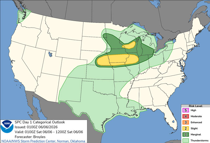
Radar indicates precipitation as showers and thunderstorms moving west to east over northern Illinois around midnight.
Scattered to numerous storms are likely to occur in the area overnight into Saturday morning (1am to 9am). The strongest storms tonight may be severe and produce torrential downpours, but are more likely near I-80.
Waves of showers and storms are expected to continue into early next week. However, many hours will be dry.
Near to slightly above average temperatures are expected this weekend before trending warmer next week.
See also: LIVE STREAMS: Arlingtoncardinal.com/StormChasers
O’HARE FORECAST …
Overnight Friday/Saturday: A 50 percent chance of showers and thunderstorms, mainly after 1am. Mostly cloudy, with a low around 68. West southwest wind around 10 mph, with gusts as high as 15 mph.
Saturday: A 30 percent chance of showers and thunderstorms, mainly after 1pm. Mostly sunny, with a high near 86. West southwest wind 5 to 10 mph becoming east northeast in the afternoon. Winds could gust as high as 15 mph.
Saturday Night: A slight chance of showers and thunderstorms. Mostly cloudy, with a low around 64. East wind around 5 mph. Chance of precipitation is 20%.
Sunday: A 20 percent chance of showers and thunderstorms after 1pm. Partly sunny, with a high near 81. East northeast wind 5 to 10 mph, with gusts as high as 15 mph.
Sunday Night: A 30 percent chance of showers and thunderstorms after 1am. Mostly cloudy, with a low around 66. East wind 5 to 10 mph.
Monday: A chance of showers before 10am, then a chance of showers and thunderstorms between 10am and 1pm, then showers and possibly a thunderstorm after 1pm. High near 84. Chance of precipitation is 80%.
Monday Night: Showers and possibly a thunderstorm. Low around 68. Chance of precipitation is 80%.
Tuesday: A chance of showers, with thunderstorms also possible after 1pm. Mostly cloudy, with a high near 87.
Tuesday Night: A chance of showers and thunderstorms. Partly cloudy, with a low around 70.
RADAR • Clouds • Temps • NWS CHGO • UV

PHOENIX FORECAST …
Red Flag Warning
URGENT – FIRE WEATHER MESSAGE
1102 AM MST Fri Jun 5 2026
RED FLAG WARNING IN EFFECT FROM 9 AM MST /9 AM PDT/ TO 11 PM MST /11 PM PDT/ SATURDAY FOR STRONG WINDS, LOW RELATIVE HUMIDITY AND ELEVATED FIRE DANGER FOR YUMA AND LA PAZ COUNTIES AND THE LOWER COLORADO RIVER VALLEY for Yuma/Martinez Lake and Vicinity/Lower Colorado River Valley AZ-Central Deserts-Lower Colorado River Valley CA-
Overnight Friday/Saturday: Clear, with a low around 78. West southwest wind 5 to 10 mph becoming light and variable after midnight. Winds could gust as high as 25 mph.
Saturday: Sunny, with a high near 106. Light and variable wind becoming west southwest 5 to 10 mph in the afternoon.
Saturday Night: Increasing clouds, with a low around 78. West southwest wind 5 to 10 mph becoming light and variable after midnight. Winds could gust as high as 20 mph.
Sunday: Sunny, with a high near 104. Southeast wind 5 to 10 mph becoming west southwest in the afternoon. Winds could gust as high as 20 mph.
Sunday Night: Mostly clear, with a low around 74. West southwest wind 5 to 10 mph becoming light and variable in the evening. Winds could gust as high as 20 mph.
Monday: Sunny, with a high near 104. Calm wind becoming south around 5 mph in the afternoon.
Monday Night: Clear, with a low around 74. West southwest wind 5 to 10 mph becoming light west after midnight.
Tuesday: Sunny, with a high near 104. Light and variable wind becoming west southwest 5 to 10 mph in the afternoon. Winds could gust as high as 20 mph.
Tuesday Night: Clear, with a low around 74. West southwest wind 5 to 10 mph becoming light and variable in the evening.
RADAR • Clouds • Temps • NWS Phoenix • UV

MIAMI FORECAST …
Rip Current Statement
Coastal Hazard Message
129 AM EDT Fri Jun 5 2026
HIGH RIP CURRENT RISK NOW IN EFFECT THROUGH SATURDAY EVENING for Coastal Broward County-Coastal Miami Dade County-
Overnight Friday/Saturday: Mostly clear, with a low around 76. East wind around 8 mph.
Saturday: Sunny, with a high near 86. East wind 9 to 13 mph, with gusts as high as 18 mph.
Saturday Night: A 20 percent chance of showers before 10pm. Mostly clear, with a low around 77. East wind 7 to 10 mph.
Sunday: A 30 percent chance of showers and thunderstorms, mainly before 7am. Mostly sunny, with a high near 88. East wind 7 to 13 mph, with gusts as high as 18 mph.
Sunday Night: Partly cloudy, with a low around 78. Southeast wind 6 to 9 mph.
Monday: A 30 percent chance of showers and thunderstorms, mainly after 2pm. Partly sunny, with a high near 89. Light east wind becoming southeast 5 to 9 mph in the morning.
Monday Night: A 30 percent chance of showers and thunderstorms, mainly before 2am. Mostly cloudy, with a low around 78. East wind 5 to 8 mph.
Tuesday: A 40 percent chance of showers and thunderstorms, mainly after 2pm. Partly sunny, with a high near 88. Light east wind increasing to 5 to 10 mph in the morning.
Tuesday Night: A 50 percent chance of showers and thunderstorms. Mostly cloudy, with a low around 78. East wind 7 to 9 mph.
RADAR • Clouds • Temps • NWS Miami • UV

LAX FORECAST …
Overnight Friday/Saturday: Mostly cloudy, with a low around 64. West southwest wind 5 to 10 mph.
Saturday: Cloudy, with a high near 69. Light and variable wind becoming west 10 to 15 mph in the morning.
Saturday Night: Patchy fog. Otherwise, cloudy, with a low around 63. West southwest wind 10 to 15 mph becoming light south southwest in the evening.
Sunday: Patchy fog before 11am. Otherwise, cloudy through mid morning, then gradual clearing, with a high near 68. South wind 5 to 10 mph becoming west 10 to 15 mph in the afternoon. Winds could gust as high as 20 mph.
Sunday Night: Patchy fog after 11pm. Otherwise, mostly cloudy, with a low around 62. West southwest wind 10 to 15 mph becoming light and variable. Winds could gust as high as 20 mph.
Monday: Patchy fog before 11am. Otherwise, mostly sunny, with a high near 72.
Monday Night: Partly cloudy, with a low around 60.
Tuesday: Mostly sunny, with a high near 72.
Tuesday Night: Mostly clear, with a low around 60.
RADAR • Clouds • Temps • NWS Los Angeles • UV

WASH DC FORECAST …
Overnight Saturday/Sunday: Partly cloudy, with a low around 68. Calm wind.
Saturday: Increasing clouds, with a high near 94. Calm wind becoming southwest 5 to 9 mph in the morning.
Saturday Night: A slight chance of showers and thunderstorms before 10pm. Increasing clouds, with a low around 71. West wind 3 to 7 mph. Chance of precipitation is 20%.
Sunday: Sunny, with a high near 91. Northwest wind 6 to 9 mph.
Sunday Night: Mostly clear, with a low around 68. North wind 3 to 6 mph.
Monday: Sunny, with a high near 87.
Monday Night: Mostly clear, with a low around 62.
Tuesday: Mostly sunny, with a high near 88.
Tuesday Night: Mostly cloudy, with a low around 65.
RADAR • Clouds • Temps • NWS Baltimore/Washington • UV
O’Hare Weather Forecast Compared to Phoenix, Miami, LA, Wash DC FRI JUN 05, 2026 11:16 PM SOURCE: National Weather Service local offices.
