
CHICAGOLAND DETAILS …
Radar indicates precipitation as thunderstorms moving from west northwest to east southeast over northeast Illinois.
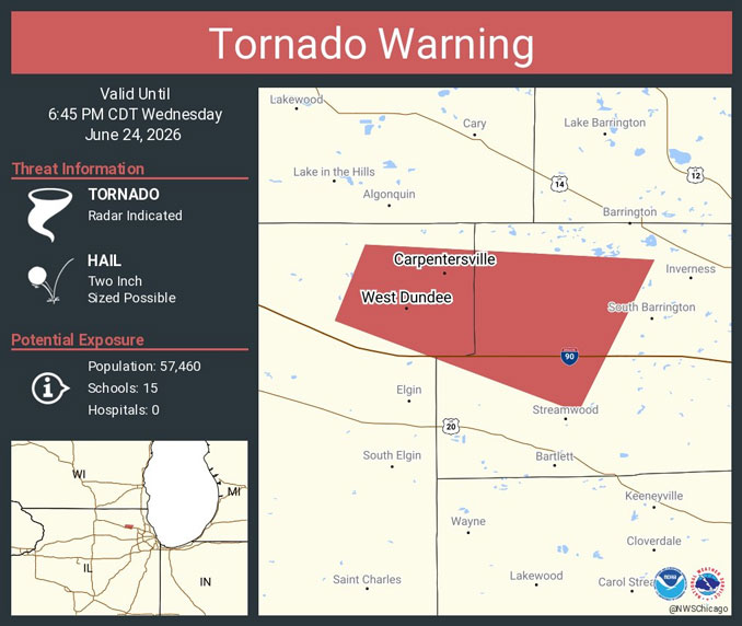
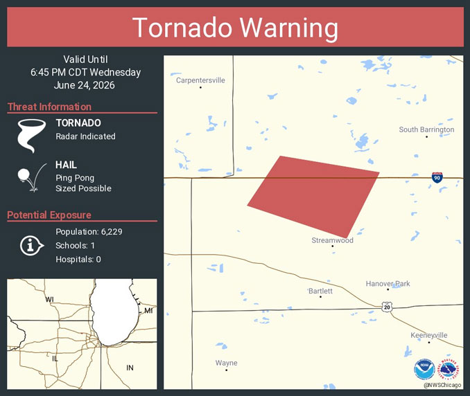
Tornado Warning in effect from June 24, 06:08 PM CDT until June 24, 06:45 PM CDT. A tornado warning was activated based on radar indication for the area of Kane County and Streamwood and Hoffman Estates in northwest Cook County. Sirens in Arlington Heights were activated, but were apparently cut short because Arlington Heights was not in the tornado warning area. This was possibly an accidental tornado siren activation in Arlington Heights. Sirens could still be heard southwest of Arlington Heights after the Arlington Heights sirens were turned off. Tornado Siren Activation is the responsibility of Northwest Central Dispatch System (NWCDS) and is based on recommendations of the National Weather Service.
See the National Weather Service official nationwide Tornado Warnings issued @x.com/NWStornado
Early Storm Damage Reports
There was early storm damage reported by Route 19 and Route 59 by about 6:45 p.m. and on Streamwood Boulevard in Streamwood. Bartlett, Illinois also has many storm damage reports.
Over 2500 ComEd customers were reported without power around 7:00 p.m. Wednesday, June 24, 2026 in the Streamwood and Bartlett area. There were many reports of trees and limbs down in Streamwood and Bartlett with at least one report of a tree down on a van in Bartlett, and one report of a tree down on a house that damaged a chimney in Streamwood.
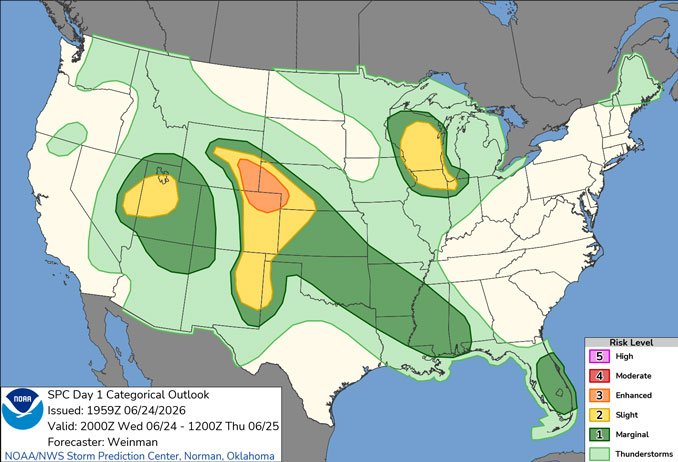
Severe Thunderstorm Watch until June 24, 10:00 PM CDT.
Scattered thunderstorms expected this afternoon and evening, a few may be severe with large hail and damaging winds.
Another chance of showers and possibly a few thunderstorms during the day Friday, with another chance of showers and thunderstorms Saturday night perhaps into early Sunday morning.
First heat wave of the summer expected early next week with the potential for highs in the 90s and peak afternoon heat indices over 100 degrees.
WATCHES, WARNINGS, ADVISORIES
Tornado Warning
Severe Thunderstorm Watch
Severe Thunderstorm Warnings in the area
See also: LIVE STREAMS: Arlingtoncardinal.com/StormChasers
Temperature Outlook …
R 62 79 | F 58 73 | SA 60 79 | SU 66 89
O’HARE FORECAST …
Wednesday Night: Showers and thunderstorms likely before midnight, then isolated showers between midnight and 1am. Mostly cloudy, with a low around 62. South wind 5 to 10 mph becoming west after midnight. Winds could gust as high as 15 mph. Chance of precipitation is 60%. New precipitation amounts of less than a tenth of an inch, except higher amounts possible in thunderstorms.
Thursday: Mostly sunny, with a high near 79. West wind 5 to 10 mph.
Thursday Night: Mostly cloudy, with a low around 58. North northwest wind around 5 mph becoming east northeast in the evening. Winds could gust as high as 10 mph.
Friday: A 30 percent chance of showers after 1pm. Mostly cloudy, with a high near 73. East northeast wind 5 to 10 mph, with gusts as high as 15 mph.
Friday Night: A 20 percent chance of showers. Mostly cloudy, with a low around 60. Northeast wind 5 to 10 mph, with gusts as high as 15 mph.
Saturday: Mostly sunny, with a high near 79.
Saturday Night: A 40 percent chance of showers and thunderstorms after 1am. Mostly cloudy, with a low around 66.
Sunday: Partly sunny, with a high near 89.
Sunday Night: Partly cloudy, with a low around 75.
RADAR • Clouds • Temps • NWS CHGO • UV
O’Hare Weather Forecast Compared to Phoenix, Miami, LA, Wash DC WED JUN 24, 2026 6:06 PM SOURCE: National Weather Service local offices.
