
CHICAGOLAND DETAILS …
Areas of frost tonight away from the urban Chicago core, with localized sub-freezing temperatures possible.
While the majority of the time will be dry, there will be a few opportunities for showers Thursday through the upcoming weekend.
Other than a possible brief warm up Saturday, temperatures will remain mostly near to below average through early next week.
See also: LIVE STREAMS: Arlingtoncardinal.com/StormChasers
ARL HTS FORECAST …
FROST ADVISORY IN EFFECT FROM 1 AM TO 8 AM CDT THURSDAY
Overnight Wednesday/Thursday: Areas of frost after 3am. Otherwise, mostly clear, with a low around 34-38 about 5am to 6am. West wind 5 to 15 mph, with gusts as high as 20 mph. Areas of frost before 8am Thursday.
Thursday: A 30 percent chance of showers after 1pm until about 6pm. Otherwise, increasing clouds, with a high near 60 about 3pm to 6pm. West southwest wind 5 to 15 mph, with gusts as high as 25 mph.
Thursday Night: Partly cloudy, with a low around 42. West wind around 5 mph becoming calm in the evening. Winds could gust as high as 15 mph.
Friday: A 30 percent chance of showers after 1pm. Partly sunny, with a high near 65. Light southwest wind becoming west southwest 5 to 10 mph in the morning.
Friday Night: Partly cloudy, with a low around 46. Southwest wind around 5 mph, with gusts as high as 15 mph.
Saturday: Mostly sunny, with a high near 74.
Saturday Night: A chance of showers and thunderstorms, then showers likely and possibly a thunderstorm after 1am. Mostly cloudy, with a low around 50. Chance of precipitation is 60%.
Sunday: A chance of showers before 1pm. Mostly cloudy, with a high near 63.
Sunday Night: Partly cloudy, with a low around 43.
RADAR • Clouds • Temps • NWS Chicago

PHOENIX FORECAST …
Wednesday Night: Areas of smoke between 9pm and 1am. Clear, with a low around 64. West southwest wind around 5 mph becoming calm.
Thursday: Sunny, with a high near 95. Calm wind becoming west southwest around 5 mph in the afternoon.
Thursday Night: Clear, with a low around 67. West southwest wind around 5 mph becoming calm in the evening.
Friday: Sunny, with a high near 100. Light and variable wind becoming west 5 to 10 mph in the afternoon.
Friday Night: Clear, with a low around 72. West southwest wind around 5 mph becoming south southeast after midnight.
Saturday: Sunny, with a high near 103. Light and variable wind becoming west 5 to 10 mph in the afternoon.
Saturday Night: Clear, with a low around 73. West southwest wind around 5 mph becoming calm after midnight.
Sunday: Sunny, with a high near 105. Calm wind becoming west around 5 mph in the afternoon.
Sunday Night: Clear, with a low around 74. West wind around 5 mph becoming calm in the evening.
RADAR • Clouds • Temps • NWS Phoenix

MIAMI FORECAST …
Wednesday Night: Partly cloudy, with a low around 76. Southeast wind 3 to 7 mph.
Thursday: Mostly sunny, with a high near 89. Light south wind increasing to 5 to 10 mph in the afternoon.
Thursday Night: Partly cloudy, with a low around 75. South wind 5 to 8 mph becoming west after midnight.
Friday: Sunny, with a high near 89. Calm wind becoming east 5 to 8 mph in the afternoon.
Friday Night: Partly cloudy, with a low around 80. Southeast wind 3 to 7 mph.
Saturday: Mostly sunny, with a high near 89. Light south wind becoming southeast 5 to 10 mph in the morning.
Saturday Night: Partly cloudy, with a low around 81. Southeast wind 5 to 8 mph.
Sunday: Partly sunny, with a high near 88. Southeast wind 7 to 11 mph.
Sunday Night: Mostly cloudy, with a low around 81. South wind 5 to 8 mph.
RADAR • Clouds • Temps • NWS Miami

LAX FORECAST …
Wednesday Night: Increasing clouds, with a low around 57. West southwest wind 5 to 10 mph becoming light after midnight. Winds could gust as high as 15 mph.
Thursday: Patchy fog before 11am. Otherwise, cloudy through mid morning, then gradual clearing, with a high near 72. Light southwest wind becoming west southwest 5 to 10 mph in the afternoon. Winds could gust as high as 15 mph.
Thursday Night: Increasing clouds, with a low around 59. West southwest wind 5 to 10 mph becoming light and variable in the evening. Winds could gust as high as 15 mph.
Friday: Patchy fog before 11am. Otherwise, cloudy through mid morning, then gradual clearing, with a high near 72. Light and variable wind becoming southwest 5 to 10 mph in the afternoon.
Friday Night: Patchy fog after 11pm. Otherwise, mostly cloudy, with a low around 59. West southwest wind 5 to 10 mph becoming southeast after midnight.
Saturday: Patchy fog before 11am. Otherwise, mostly sunny, with a high near 74.
Saturday Night: Mostly clear, with a low around 58.
Sunday: Sunny, with a high near 77.
Sunday Night: Mostly clear, with a low around 59.
RADAR • Clouds • Temps • NWS Los Angeles

WASH DC FORECAST …
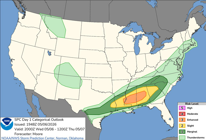
This Hazardous Weather Outlook is for the Maryland portion of the Chesapeake Bay, Tidal Potomac River, and I-95 corridor through central Maryland, northern Virginia, and District of Columbia Wednesday night. Widely scattered thunderstorms are possible through 8pm Wednesday night. Storms may produce wind gusts to near gale force, and Special Marine Warnings may be needed.
Wednesday Night: Showers and thunderstorms before 2am, then a chance of showers between 2am and 5am. Low around 53. North wind 5 to 7 mph. Chance of precipitation is 80%. New precipitation amounts of less than a tenth of an inch, except higher amounts possible in thunderstorms.
Thursday: A chance of showers, mainly after 4pm. Cloudy, then gradually becoming mostly sunny, with a high near 66. North wind around 6 mph. Chance of precipitation is 30%.
Thursday Night: Mostly cloudy, then gradually becoming clear, with a low around 47. Calm wind becoming northwest around 5 mph after midnight.
Friday: Increasing clouds, with a high near 70. Calm wind becoming west 5 to 9 mph in the morning.
Friday Night: Mostly cloudy, with a low around 53. Calm wind becoming south around 5 mph after midnight.
Saturday: Showers likely, with thunderstorms also possible after 2pm. Partly sunny, with a high near 73. Chance of precipitation is 60%.
Saturday Night: Mostly clear, with a low around 54.
Sunday: A chance of showers after 2pm. Mostly sunny, with a high near 81. Chance of precipitation is 30%.
Sunday Night: Showers likely, mainly after 8pm. Mostly cloudy, with a low around 58. Chance of precipitation is 70%.
RADAR • Clouds • Temps • NWS Baltimore/Washington
O’Hare Weather Forecast Compared to Phoenix, Miami, LA, Washington DC WED MAY 06, 2026 6:51 PM
