
See also: LIVE STREAMS: Arlingtoncardinal.com/StormChasers
Monday’s weather at O’Hare International Airport and Arlington Heights will be slightly warmer than Sunday, and more comfortable with lighter winds. The warming trend will continue through Thursday, except near the lake on Wednesday.
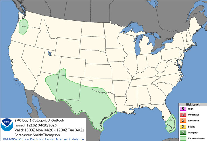
Next chances for thunderstorms as early as Tuesday afternoon, but more likely Tuesday evening and overnight and near/south of I-80. More widespread showers and thunderstorms are expected with another cold front towards the end of the week.
ARL HTS FORECAST …
Monday: Mostly sunny, with a high near 55. Southeast wind 5 to 10 mph becoming south southwest in the afternoon.
Monday Night: Mostly cloudy, with a low around 45. South wind 10 to 15 mph, with gusts as high as 20 mph.
Tuesday: Mostly sunny, with a high near 75. Southwest wind around 15 mph, with gusts as high as 30 mph.
Tuesday Night: A 20 percent chance of showers and thunderstorms before 1am. Partly cloudy, with a low around 49. West southwest wind around 5 mph becoming north after midnight. Winds could gust as high as 15 mph.
Wednesday: Sunny, with a high near 70. North northeast wind around 5 mph becoming east in the afternoon. Winds could gust as high as 10 mph.
Wednesday Night: Partly cloudy, with a low around 54.
Thursday: Mostly sunny, with a high near 80. Breezy.
Thursday Night: A chance of showers and thunderstorms, then showers likely and possibly a thunderstorm after 1am. Mostly cloudy, with a low around 61.
RADAR • Clouds • Temps • NWS Chicago

PHOENIX FORECAST …
Monday: Sunny, with a high near 94. Calm wind becoming southwest around 5 mph in the afternoon.
Monday Night: Increasing clouds, with a low around 68. West wind around 5 mph becoming calm after midnight.
Tuesday: Sunny, with a high near 95. Light and variable wind becoming southwest 5 to 10 mph in the morning.
Tuesday Night: Mostly clear, with a low around 63. West southwest wind 5 to 10 mph becoming light southwest after midnight. Winds could gust as high as 20 mph.
Wednesday: Sunny, with a high near 87. Light south southwest wind becoming west southwest 5 to 10 mph in the morning. Winds could gust as high as 20 mph.
Wednesday Night: Partly cloudy, with a low around 61. West wind 5 to 10 mph becoming light after midnight.
Thursday: Sunny, with a high near 88. Light and variable wind becoming west southwest 5 to 10 mph in the afternoon.
Thursday Night: Mostly clear, with a low around 63. West southwest wind around 5 mph becoming calm after midnight.
RADAR • Clouds • Temps • NWS Phoenix

MIAMI FORECAST …
Rip Current Statement in the area
Monday: A slight chance of showers, then a chance of showers and thunderstorms after 11am. Partly sunny, with a high near 81. Northeast wind 6 to 11 mph, with gusts as high as 18 mph. Chance of precipitation is 50%. New rainfall amounts between a tenth and quarter of an inch, except higher amounts possible in thunderstorms.
Monday Night: A chance of showers and thunderstorms before 2am, then a slight chance of showers between 2am and 3am. Mostly cloudy, with a low around 70. Northeast wind around 14 mph, with gusts as high as 26 mph. Chance of precipitation is 30%.
Tuesday: Sunny, with a high near 77. Breezy, with a northeast wind 16 to 18 mph, with gusts as high as 28 mph.
Tuesday Night: Partly cloudy, with a low around 69. East wind 10 to 14 mph, with gusts as high as 25 mph.
Wednesday: Partly sunny, with a high near 77. East wind 10 to 14 mph, with gusts as high as 20 mph.
Wednesday Night: Mostly cloudy, with a low around 68. East wind 8 to 10 mph.
Thursday: Mostly cloudy, with a high near 78. East wind 8 to 11 mph, with gusts as high as 18 mph.
Thursday Night: Mostly cloudy, with a low around 69. East wind around 9 mph.
RADAR • Clouds • Temps • NWS Miami

LAX FORECAST …
Monday: Cloudy through mid morning, then gradual clearing, with a high near 69. Light and variable wind becoming west southwest 10 to 15 mph in the morning.
Monday Night: Partly cloudy, with a low around 56. West southwest wind 10 to 15 mph becoming light west northwest after midnight.
Tuesday: Rain likely after 11am. Mostly cloudy, with a high near 68. Southeast wind 5 to 10 mph becoming southwest 10 to 15 mph in the afternoon. Chance of precipitation is 70%. New precipitation amounts of less than a tenth of an inch possible.
Tuesday Night: Rain likely before 11pm. Mostly cloudy, then gradually becoming mostly clear, with a low around 57. West northwest wind 5 to 15 mph. Chance of precipitation is 60%. New precipitation amounts of less than a tenth of an inch possible.
Wednesday: Sunny, with a high near 68. West wind 5 to 10 mph increasing to 10 to 15 mph in the afternoon. Winds could gust as high as 20 mph.
Wednesday Night: Mostly clear, with a low around 54.
Thursday: Mostly sunny, with a high near 70.
Thursday Night: Mostly cloudy, with a low around 56.
RADAR • Clouds • Temps • NWS Los Angeles

WASH DC FORECAST …
Freeze Warning overnight Monday to Tuesday morning
Hazardous Weather Outlook related to elevated fire risk and gale force winds Monday afternoon.
Monday: Scattered showers, mainly before noon, then scattered sprinkles after 1pm. Partly sunny, with a high near 56. Northwest wind 10 to 15 mph, with gusts as high as 28 mph. Chance of precipitation is 30%.
Monday Night: Widespread frost after 2am. Otherwise, mostly cloudy, then gradually becoming clear, with a low around 32. Northwest wind 5 to 8 mph becoming calm after midnight.
Tuesday: Widespread frost before 10am. Otherwise, sunny, with a high near 62. Calm wind becoming southwest around 6 mph in the afternoon.
Tuesday Night: A slight chance of showers after 2am. Partly cloudy, with a low around 50. South wind around 6 mph. Chance of precipitation is 20%.
Wednesday: A chance of showers, then showers likely and possibly a thunderstorm after 2pm. Mostly cloudy, with a high near 74. Southwest wind around 7 mph becoming west in the afternoon. Chance of precipitation is 60%.
Wednesday Night: Showers likely and possibly a thunderstorm before 8pm. Partly cloudy, with a low around 53. Chance of precipitation is 60%.
Thursday: Sunny, with a high near 77.
Thursday Night: Mostly clear, with a low around 55.
