
The air temperature will turn sharply colder today, Wednesday, January 14, 2026, behind a strong cold front passing early Wednesday morning with northerly winds gusting up to 30-40 mph.
Wind-whipped snow showers are likely this morning near and east of I-39, with lake enhancement commencing into northwest Indiana. A band of gusty snow showers along a strong cold front extended back to southwest Wisconsin as of 4:50 a.m. CST. These snow showers can be expected to move steadily south across the area between 6:00 a.m. and 11:00 a.m. CST. Embedded bursts of heavier snow may tend to focus east of I-39, which when paired with northerly winds gusting to 35 to 40 mph, may reduce visibility below one mile at times. A coating to around a half inch of snow may accumulate on colder or untreated surfaces, with localized one inch amounts possible in far northwest Indiana.
Air temperatures was still above freezing (40°F at 6:20 a.m.) but will quickly falling into the 20s by 10:00 a.m. with snow. Slick spots may develop on some roads. Motorists are advised to leave extra time to reach their destinations Wednesday morning and be prepared to encounter localized hazardous travel. Take it slow and keep a safe following distance when driving.
A Winter Weather Advisory remains in effect for northern and eastern Porter County for lake effect snow showers today and tonight, localized accumulations of 2-5 inches expected, especially northeast Porter County.
A “Clipper Express” pattern may materialize from the end of this week into early next week with periodic opportunities for snow, reinforcing shots of cold air, and blustery northwest winds. A “Clipper Express” is a series of fast-moving low-pressure storms from ALberta Canada that rapidly sweep across the northern U.S., delivering quick bursts of light, powdery snow, strong winds, and a shot of bitter cold air. Clipper Express systems often include dangerous wind chills, creating a “train” of winter weather. Clipper Express systems are known for bringing quick changes and can enhance lake-effect snow as they pass the Great Lakes.
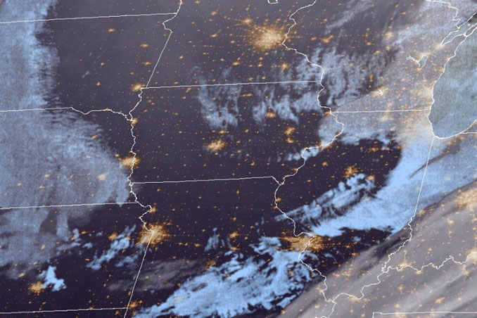
Weather Radarat 6:20 a.m. Wednesday, January 14, 2026 shows snow precipitation moving into Illinois from Wisconsin in a south-southeasterly direction.
High clouds have been moving from the southwest to northeast overnight, and low clouds have been sagging down into Illinois from Wisconsin overnight.
See also Arlingtoncardinal.com/clouds
O’HARE FORECAST …
Wednesday: Periods of snow showers with scattered flurries before 1pm, then scattered flurries between 1pm and 4pm. Temperature falling to around 21 by 4pm. Blustery, with a north northwest wind 20 to 25 mph, with gusts as high as 40 mph. Chance of precipitation is 80%. Total daytime snow accumulation of less than a half inch possible.
Wednesday Night: Partly cloudy, with a low around 14. Wind chill values as low as -1. Blustery, with a north northwest wind 15 to 25 mph, with gusts as high as 35 mph.
Thursday: Mostly sunny, with a high near 26. Wind chill values as low as -2. Northwest wind 10 to 15 mph becoming southwest in the afternoon. Winds could gust as high as 25 mph.
Thursday Night: Snow. Low around 22. South southwest wind 10 to 15 mph, with gusts as high as 20 mph. Chance of precipitation is 80%. New snow accumulation of around an inch possible.
Friday: Snow likely before noon, then a chance of snow showers after noon. Cloudy, with a high near 37. Breezy, with a west wind 15 to 20 mph, with gusts as high as 30 mph. Chance of precipitation is 60%.
Friday Night: A 50 percent chance of snow showers. Cloudy, with a low around 15.
Saturday: A 40 percent chance of snow showers. Mostly cloudy, with a high near 19.
Saturday Night: Mostly cloudy, with a low around 8.
Sunday: A chance of snow showers after noon. Partly sunny, with a high near 18.
Sunday Night: A chance of snow showers before midnight. Mostly cloudy, with a low around 9.
M.L.King Day (Monday): Mostly cloudy, with a high near 17.
Monday Night: Mostly cloudy, with a low around 4.
Tuesday: Partly sunny, with a high near 18.
LAKE TEMPS …
Southern Lake Michigan Water Temperatures
National Weather Service Chicago/Romeoville IL
901 AM CST Tue Jan 13 2026
Lake Michigan Water Temperatures…
Chicago Shore………..34.
Chicago Crib…………40.
Michigan City………..36.
&&
M is for missing data that is normally available. Chicago Shore, Chicago Crib, and Michigan City are read every day of the year.
Measured at a depth of 60 ft for Chicago Crib and 30 ft for Michigan City. May not represent surface temperature.
For Lake Michigan water levels, please see:
water.usace.army.mil/office/lre/forecast/weekly
january.chicagoweatherstation.com
Chicago Weather Forecast for your MAC/PC/TABLET includes surrounding suburbs.
^^ MOBILE? USE VOICE MIC ^^
facebook …
Please ‘LIKE’ the ‘Arlington Cardinal Page. See all of The Cardinal Facebook fan pages at Arlingtoncardinal.com/about/facebook …
Help fund The Cardinal Arlingtoncardinal.com/sponsor
