
The second storm system passing over Arlington Heights, which triggered a NWS Winter Weather Advisory, is looking like a fizzled snow system in our immediate area. At 7:00 p.m., barely one-half inch snow accumulated above the 7-10 inch snow cover in Arlington Heights from last weekend’s snow system.
The NWS hourly forecast Monday morning indicated Arlington Heights could have 1.5 inches of new snowfall by 7:00 p.m. Monday. The total snowfall for Monday’s system will be about 1 inch, as the radar snow echoes do not look robust after 7:00 p.m., and the snow intensity is forecast to diminish by midnight.
The larger concern is extreme cold forecast for Wednesday/Thursday overnight (Low 2°F), Thursday (High 14°F), and overnight Thursday/Friday (Low -1°F).
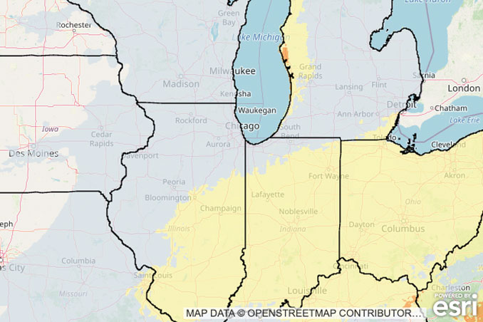
Weather Radarat at 7:30 p.m. shows diminishing precipitation on the northern fringe south of the Illinois-Wisconsin border moving west to east. The system appears more robust around Peoria, Illinois and south of Kankakee.
See also Arlingtoncardinal.com/clouds
With steady snow through this evening, take it slow and keep a safe following distance if you will be driving. For latest #ILwx road conditions via @IDOT_Illinois go to: https://t.co/OBUKMPnluQ. For #INwx conditions via @INDOTNorthwest, go to https://t.co/KagYYwQEHr. pic.twitter.com/3ZYqdFFwsp
— NWS Chicago (@NWSChicago) December 1, 2025
O’HARE FORECAST …
..WINTER WEATHER ADVISORY REMAINS IN EFFECT UNTIL MIDNIGHT CST TONIGHT…
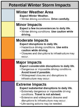
WHAT…Snow and winter driving conditions occurring. Total snow accumulations between 1 and 4 inches, highest south of the Kankakee River Valley.
WHERE…Portions of central, east central, north central, and northeast Illinois.
WHEN…Until midnight CST tonight.
IMPACTS…Plan on slippery road conditions. The hazardous conditions will impact the evening commute Monday.
PRECAUTIONARY/PREPAREDNESS ACTIONS…
Slow down and use caution while traveling. The latest road conditions for Illinois can be obtained at www.gettingaroundillinois.com.
Monday Night: Snow before midnight, then a chance of snow with intermittent flurries between midnight and 2am. Low around 17. South wind 5 to 10 mph becoming west northwest after midnight. Chance of precipitation is 100%. Total nighttime snow accumulation of around an inch possible.
Tuesday: Mostly cloudy, with a high near 22. Northwest wind 5 to 10 mph becoming southwest in the afternoon.
Tuesday Night: Cloudy, with a temperature falling to near 18 by 8pm, then rising to around 23 during the remainder of the night. South southwest wind 10 to 15 mph, with gusts as high as 20 mph.
Wednesday: Snow showers likely, mainly after noon. Cloudy, with a high near 33. South southwest wind 10 to 15 mph becoming northwest in the afternoon. Winds could gust as high as 20 mph. Chance of precipitation is 60%. New snow accumulation of less than a half inch possible.
Wednesday Night: A 30 percent chance of snow showers before midnight. Partly cloudy, with a low around 2. Northwest wind around 10 mph, with gusts as high as 20 mph.
Thursday: Sunny, with a high near 14.
Thursday Night: Partly cloudy, with a low around -1.
Friday: Partly sunny, with a high near 25.
Friday Night: Mostly cloudy, with a low around 17.
Saturday: Mostly cloudy, with a high near 29.
Saturday Night: A chance of snow. Mostly cloudy, with a low around 16.
Sunday: Mostly cloudy, with a high near 26.
Sunday Night: Mostly cloudy, with a low around 10.
Monday: Partly sunny, with a high near 25.
LAKE TEMPS …
Southern Lake Michigan Water Temperatures
National Weather Service Chicago/Romeoville IL
1005 AM CST Mon Dec 1 2025
Lake Michigan Water Temperatures…
Chicago Shore………..39.
Chicago Crib…………46.
Michigan City………..42.
South Mid Lake Buoy…..46.
&&
M is for missing data that is normally available. Chicago Shore, Chicago Crib, and Michigan City are read every day of the year.
Measured at a depth of 60 ft for Chicago Crib and 30 ft for Michigan City. May not represent surface temperature.
For Lake Michigan water levels, please see:
water.usace.army.mil/office/lre/forecast/weekly
december.chicagoweatherstation.com
Chicago Weather Forecast for your MAC/PC/TABLET includes surrounding suburbs.
^^ MOBILE? USE VOICE MIC ^^
facebook …
Please ‘LIKE’ the ‘Arlington Cardinal Page. See all of The Cardinal Facebook fan pages at Arlingtoncardinal.com/about/facebook …
Help fund The Cardinal Arlingtoncardinal.com/sponsor
