
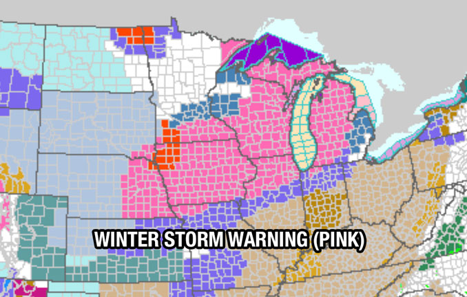
WINTER STORM WARNING IN EFFECT 3 AM FRIDAY TO NOON CST SATURDAY
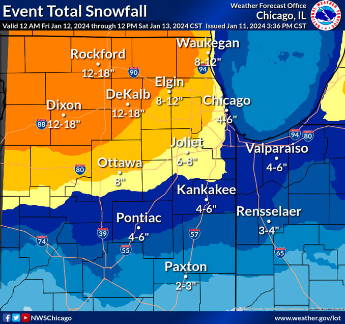
The current forecast at 3:30 PM indicates snowfall accumulation in the Arlington Heights, O’Hare International Airport area will be 10.4 inches.
FRIDAY MORNING TO FRIDAY NIGHT…
Major winter storm (>80% confidence in warning impacts in warned counties) with periods of heavy, primarily wet snow and strong easterly winds pre-dawn Friday through Friday evening and lighter snow with strong westerly winds and blowing/drifting snow impacts lingering through at least Saturday morning.
Winter Storm Warning issued for northern Illinois near and north of the Illinois and Kankakee Rivers, with Winter Weather Advisories south and east where confidence is lower in magnitude of impacts.
Winter Weather Advisories issued for a tier of counties south of the Winter Storm Warning where snow is expected to change entirely to rain, and across our southern tier of counties where the combination of snow and strong westerly winds Friday night will lead to hazardous conditions. (In other words, all forecast zones will be in a winter headline Friday evening).
A period of heavy (60-70%+ chance of >1″/hour) to briefly intense (30-40% chance of >2″/hour) snowfall rates is likely just prior to and during the Friday AM commute, centered over northern Illinois near/north of the Illinois and Kankakee Rivers, paired with easterly wind gusts to 30-35 mph.
The next round of hazardous to dangerous travel conditions with 1″+ hour snowfall rates will spread southeast mid Friday afternoon through Friday evening. Strong northwest to west winds gusting up to 45 to 50 mph Friday evening and night may cause blowing and drifting snow and very low visibility, especially on north to south oriented roads.
Strong onshore winds off a still mild Lake Michigan will once again likely cut into if not eliminate snow accumulations near the immediate shore, especially late Friday morning through the early evening, including east of I-90/94 in Illinois, and north of I-80/94 in Indiana.
After the “thump” of snow through mid Friday morning, the rain/snow line will push as far north as the I-80/I-88 corridor, limiting additional accumulations for several hours before changing back to snow in the afternoon and evening.
SATURDAY MORNING THROUGH WEDNESDAY
Dangerously cold temperatures and wind chills for several days next week.
Bitterly cold air will spread across the region this weekend and continue through the middle of next week. Subzero low temps are expected each morning Sunday through Wednesday with the coldest morning possibly Monday morning with lows in the -10 to -15 range for most of the area. Westerly winds in the 10-15 mph range with higher gusts at times will likely push wind chills into warning criteria of -30 for at least a few nights. In fact, if the current temp/wind forecast materializes, its possible that wind chills will remain below zero from Saturday evening through midday Wednesday for the entire area.
A weak system may bring some light snow to areas south of the County Warning Area Sunday and the models show various weak impulses moving across the area through the middle of next week. Any one of these could bring some flurries or a chance of light snow but confidence is very low at this point in time.
Weather Radar in northeast Illinois was clear at 3:15 p.m. Thursday, while the leading edge of precipitation was near the Nebraska-Iowa border and the Kansas-Missouri border.
See also Arlingtoncardinal.com/clouds
Travel will be very difficult across most of the area tomorrow. If it cannot be avoided, however, and you must travel, please take the time to make sure that your car has plenty of gas and a fully stocked emergency kit. And use extra caution when driving in adverse weather! pic.twitter.com/5DBAsixBln
— NWS Chicago (@NWSChicago) January 11, 2024
With the upcoming snow once again expected to be of the wet and heavy variety, it’s especially important to be smart about shoveling! Remember to stay hydrated, take frequent breaks, and move only small amounts with each shovel pass. #ILwx #INwx pic.twitter.com/ONGtvgXyU5
— NWS Chicago (@NWSChicago) January 11, 2024
With a winter storm slated to impact the area tomorrow, now is the time to ensure that you have all of your necessities as well everything you need in the event of an emergency, both in your home as well as in your car if you are unable to avoid travelling. #ILwx #INwx pic.twitter.com/E3bZJDhWNp
— NWS Chicago (@NWSChicago) January 11, 2024
O’HARE FORECAST …
Thursday Afternoon: Mostly cloudy, with a high near 33. West southwest wind 5 to 10 mph.
Thursday Overnight: Snow, mainly after 1am. Temperature falling to near 26 by 8pm, then rising to around 32 during the remainder of the night. West southwest wind 5 to 10 mph becoming east 10 to 15 mph after midnight. Winds could gust as high as 25 mph. Chance of precipitation is 100%. New snow accumulation of 1 to 2 inches possible.
Friday: Snow, possibly mixed with rain, becoming all snow after 4pm. The snow could be heavy at times. High near 34. Breezy, with an east wind 15 to 25 mph, with gusts as high as 35 mph. Chance of precipitation is 100%. New snow accumulation of 3 to 7 inches possible.
Friday Night: Snow. Patchy blowing snow after 10pm. Low around 22. Breezy, with a north northeast wind 15 to 20 mph becoming west 20 to 25 mph after midnight. Winds could gust as high as 40 mph. Chance of precipitation is 100%. New snow accumulation of 2 to 4 inches possible.
Saturday: Periods of snow showers. Areas of blowing snow. High near 22. Windy, with a west wind 25 to 30 mph, with gusts as high as 40 mph. Chance of precipitation is 80%.
Saturday Night: A 50 percent chance of snow showers. Mostly cloudy, with a low around 0. Breezy.
Sunday: A 30 percent chance of snow showers. Partly sunny and cold, with a high near 4. Breezy.
Sunday Night: Mostly cloudy, with a low around -9. Breezy.
M.L.King Day – Monday: Mostly cloudy and cold, with a high near 3.
Monday Night: A chance of snow after midnight. Mostly cloudy, with a low around -9.
Tuesday: Partly sunny and cold, with a high near 1.
Tuesday Night: Partly cloudy, with a low around -5.
Wednesday: Mostly cloudy, with a high near 17. Breezy.
LAKE TEMPS …
SOUTHERN LAKE MICHIGAN WATER TEMPERATURES
NATIONAL WEATHER SERVICE CHICAGO/ROMEOVILLE IL
943 AM CST Thu Jan 11 2024
LAKE MICHIGAN WATER TEMPERATURES…
CHICAGO SHORE………..37.
CHICAGO CRIB…………41.
MICHIGAN CITY………..38.
SOUTH MID LAKE BUOY…..42.
&&
M IS FOR MISSING DATA THAT IS NORMALLY AVAILABLE.
THE MICHIGAN CITY WATER TEMPERATURE SENSOR IS LOCATED AT A WATER INTAKE ONE MILE OFFSHORE AND 60 FEET BELOW THE WATER SURFACE. IT IS READ EVERY DAY OF THE YEAR.
january.chicagoweatherstation.com
Chicago Weather Forecast for your MAC/PC/TABLET includes surrounding suburbs.
^^ MOBILE? USE VOICE MIC ^^
facebook …
Please ‘LIKE’ the ‘Arlington Cardinal Page. See all of The Cardinal Facebook fan pages at Arlingtoncardinal.com/about/facebook …
Help fund The Cardinal Arlingtoncardinal.com/sponsor
WINTER STORM WARNING …
URGENT – WINTER WEATHER MESSAGE
National Weather Service Chicago IL
243 PM CST Thu Jan 11 2024
Lake IL-Northern Cook-Central Cook-
Including the cities of Waukegan, Buffalo Grove, Mundelein,
Gurnee, Evanston, Des Plaines, Schaumburg, Palatine, Northbrook,
Chicago, Cicero, Oak Lawn, Oak Park, and La Grange
243 PM CST Thu Jan 11 2024
…WINTER STORM WARNING IN EFFECT FROM 3 AM FRIDAY TO NOON CST SATURDAY…
* WHAT…Heavy snow, strong winds, and dangerous travel
conditions expected. Total snow accumulations in excess of 8
inches and wind gusts up to 45 mph expected, with the highest
snow accumulations away from Lake Michigan.
* WHERE…Lake IL, Northern Cook, and Central Cook Counties.
* WHEN…From 3 AM Friday to noon CST Saturday.
* IMPACTS…Travel could be very difficult to impossible. Areas
of blowing snow could significantly reduce visibility. The
hazardous conditions could impact the morning or evening
commute.
* ADDITIONAL DETAILS…Snow will mix with rain near Lake Michigan
and limit snow accumulations after mid Friday morning.
Elsewhere, snow rates may exceed 1 inch per hour at times.
Westerly wind gusts up to 45 mph are expected primarily Friday
evening and may lead to areas of blowing snow and very low
visibility.
PRECAUTIONARY/PREPAREDNESS ACTIONS…
If you must travel, keep an extra flashlight, food, and water in
your vehicle in case of an emergency.
The latest road conditions for Illinois can be obtained on the
internet at www.gettingaroundillinois.com.
