
Warmer air over a snow-covered ground causes fog, but these conditions will be diminishing Saturday night into Sunday.
Dense fog Saturday evening was primarily focused near the Lake Michigan shore.
Web cams and near-lake observation sites indicate areas near Lake Michigan were the foggiest in Chicagoland.
Periods of light rain and/or drizzle Saturday night into Sunday morning, but no snow — not even a flurry.
SAD …
Seasonal Affective Disorder (SAD) is a type of depression characterized by a recurrent seasonal pattern, with symptoms lasting about 4−5 months out of the year. The signs and symptoms of SAD include those associated with depression as well as disorder-specific symptoms that differ for winter-pattern versus summer-pattern SAD.
In most cases, SAD symptoms start in the late fall or early winter and go away during the spring and summer, known as winter-pattern SAD or winter depression.
After a winter-friendly, mild November and December, January 2024 with snow and ice, sub-freezing weather, and above-normal periods of fog, served as a reminder that winter was still the season in Chicagoland.
There is reason for optimism as the last week of January will bring back mild temperatures in the 40s Monday through Thursday. There was a high in the 50s forecast for Thursday indicated Saturday morning, but this unseasonably mild forecast for Thursday trended downward to the 40s Saturday night.
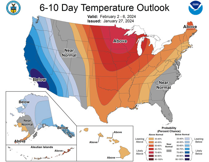
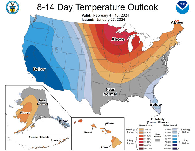
Also, the NWS Climate Prediction Center indicates an above average temperature probability for both the 6-10 Day Temperature Outlook and the 8-14 Day Temperature Outlook.
Annual Weather Milestones
There are also some annual milestones happening now that signal the weakening of winter …
This weekend marks the beginning of sunsets after 5:00 p.m. Sunset Sunday is 5:01 p.m. after a 5:00 p.m. sunset Saturday.
Following the shortest days that occur late December and early January, the daylight time periods are gaining about 2 minutes, and occasionally 3 minutes, per day as Chicagoland approaches the Vernal Equinox (Spring Equinox) Tuesday, March 19, 2024. By early February, just days away, you can start to feel the heat of the sun and brighter skies returning.
This weekend also marks the first day that the normal temperature begins to rise in 2024. The normal low was 16°F Saturday morning, and the normal low is 17°F on Sunday with the 1°F rise marking the first normal temperature increase of the new year.
The increase in normal high occurs January 30 with a rise from 31°F to 32°F.
Weather Radar Saturday afternoon into evening showed rain passing south of Kankakee and moving northeast toward Indiana.
See also Arlingtoncardinal.com/clouds
Dense fog will gradually diminish this PM before our next round of rain arrives this evening, mainly for those SE of I-55. Additional precipitation chances are expected for Mon night into Tue with otherwise above normal temps. #ILwx #INwx pic.twitter.com/hAljOXrlMn
— NWS Chicago (@NWSChicago) January 27, 2024
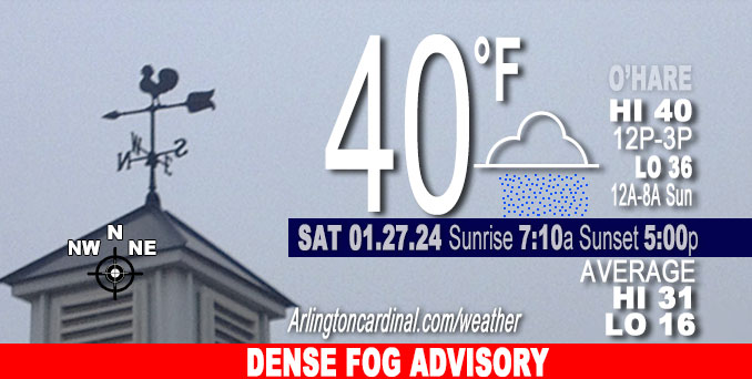
O’HARE FORECAST …
Saturday: Areas of dense fog, especially near the Lake Michigan shore. Otherwise, cloudy, with a high near 40. North northeast wind 5 to 10 mph.
Saturday Night: A chance of drizzle, mainly before 5am. Patchy fog. Otherwise, cloudy, with a low around 36. North wind around 15 mph, with gusts as high as 20 mph.
Sunday: A slight chance of drizzle before 8am. Cloudy, with a high near 38. North wind 10 to 15 mph, with gusts as high as 25 mph.
Sunday Night: Mostly cloudy, with a low around 29. West wind 5 to 10 mph.
Monday: Mostly sunny, with a high near 42. Southwest wind 5 to 10 mph, with gusts as high as 15 mph.
Monday Night: Rain likely after midnight, mixing with snow after 3am. Mostly cloudy, with a low around 35. South southwest wind 5 to 10 mph, with gusts as high as 20 mph. Chance of precipitation is 60%.
Tuesday: A chance of rain and snow showers, mainly before noon. Cloudy, with a high near 39. Chance of precipitation is 40%.
Tuesday Night: Mostly cloudy, with a low around 34.
Wednesday: Partly sunny, with a high near 43.
Wednesday Night: Mostly cloudy, with a low around 34.
Thursday: Partly sunny, with a high near 45.
Thursday Night: Mostly cloudy, with a low around 33.
Friday: Partly sunny, with a high near 42.
Friday Night: Mostly cloudy, with a low around 30.
Saturday: Mostly sunny, with a high near 39.
LAKE TEMPS …
SOUTHERN LAKE MICHIGAN WATER TEMPERATURES
NATIONAL WEATHER SERVICE CHICAGO/ROMEOVILLE IL
901 AM CST Sat Jan 27 2024
LAKE MICHIGAN WATER TEMPERATURES…
CHICAGO SHORE………..34.
CHICAGO CRIB…………36.
MICHIGAN CITY………..33.
SOUTH MID LAKE BUOY…..40.
&&
M IS FOR MISSING DATA THAT IS NORMALLY AVAILABLE.
THE MICHIGAN CITY WATER TEMPERATURE SENSOR IS LOCATED AT A WATER INTAKE ONE MILE OFFSHORE AND 60 FEET BELOW THE WATER SURFACE. IT IS READ EVERY DAY OF THE YEAR.
january.chicagoweatherstation.com
Chicago Weather Forecast for your MAC/PC/TABLET includes surrounding suburbs.
^^ MOBILE? USE VOICE MIC ^^
facebook …
Please ‘LIKE’ the ‘Arlington Cardinal Page. See all of The Cardinal Facebook fan pages at Arlingtoncardinal.com/about/facebook …
Help fund The Cardinal Arlingtoncardinal.com/sponsor
AREA FORECAST DISCUSSION …
Area Forecast Discussion
National Weather Service
Chicago/Romeoville, IL
341 PM CST Sat Jan 27 2024
.SHORT TERM… Issued at 300 PM CST Sat Jan 27 2024
Through Sunday night…
Key Messages:
– Lingering dense fog this evening focused near the Lake Michigan shore
– Periods of light rain and/or drizzle tonight into Sunday morning
– Areal Flood Watch will be canceled this afternoon (see Hydrology discussion for details)
The coverage of dense fog inland diminished enough to allow the Dense Fog Advisory to expire due to increasing north-northeasterly low level winds. Meanwhile, web cams and near lake observation sites still indicate things are pretty socked in visibility wise. Despite increasing northerly low-level flow, the areas of dense fog over the lake and near/along the shore could ooze inland a bit until winds strengthen enough to hopefully erode lingering dense fog. Though there is uncertainty regarding exact trends, opted to extend the Dense Fog Advisory for the lakeshore counties through this evening (12 AM CST) in collaboration with WFO MKX. We`ll also have to keep an eye on observations across inland areas for the possibility of visibility dipping back down toward and after sunset. In the official forecast, maintained patchy dense fog inland and areas of dense fog near the lake through this evening.
Robust neutral to negatively tilted short-wave and associated ~1005 mb surface low pressure over the Mid South will track across the Ohio Valley region tonight into Sunday morning. Northern extent of the appreciable primarily light rain should make it to about the I-55 corridor or thereabouts. As a minor additional note, some forecast soundings suggest that the column may cool enough aloft for a mix with wet snow later tonight in portions of northwest Indiana. The thinking is that with wet bulb temps at least in the mid 30s, this should correspond with enough lower level melting energy to keep p-type at the surface as rain.
Northwest of the cut-off of the deformation type rain, ascent through the already deep lower level saturated layer should yield patchy drizzle to areas of drizzle as far north as far northern Illinois where mid-level moisture will be lacking. It`s uncertain to what extent drizzle will be able to knock visibility back down amidst patchy fog given the aforementioned stronger northerly winds.
As the surface low pressure pulls east on Sunday, lingering drizzle and/or light rain over the southeast half or third of the CWA will come to an end. Breezy northerly winds gusting to 20-25 mph (up to 30 mph) near the lake will add a chill to otherwise well above normal temps in the mid to upper 30s. Lack of cold and dry air advection on Sunday night may make it tough to erode lingering stratus across the region, likely keeping lows propped up more than they would have been otherwise.
— Castro/NWS Chicago
.LONG TERM… Issued at 341 PM CST Sat Jan 27 2024
Monday through Saturday…
Key Messages:
– Increasing confidence for disorganized and scattered precipitation chances (40-60%) starting early Tuesday remain. Some uncertainty remains with precip type.
– A developing blocking pattern on the back end of the week will allow temperatures to hover above average with dry conditions ending out the week.
Monday and Tuesday:
Upper level northwest flow should prevail this week from central U.S. ridging. Low and mid level mixing of cooler and drier air Monday may finally help clear most of the stratus deck, but. However, with warm advection returning aloft, the strengthening inversion may trap lingering stratus that hasn`t cleared yet. As is common this time of year, confidence is on the lower side with stratus trends on Monday. Have partly cloudy skies in the official forecast and cautiously hopeful that at least portions of the area can see the sun for the first time in a week.
Any temporary clearing will be short lived with reestablishing coverage from an approaching clipper-type shortwave on the back end of the day of Monday through Monday night. The pinching mid- level trough will have a curved vorticity maxima at its center with CVA filling along the front edge, helping to support the system. This system will bring a ~40% chance of rain showers Monday night with the warm advection wing as the column starts warm enough for primarily rain. There may be enough cooling aloft toward early Tuesday for wet snow to mix in, with no accumulation expected given temps above freezing.
In the cold advection regime on the back-side of the clipper on Tuesday, precipitation chances (20-40% in the morning) will be tied to height falls and mid-level cooling with the lingering low-level moisture available just ahead of the trough axis. Expecting rain and poor quality wet snow showers, particularly in the morning, but possibly lingering into the afternoon and evening for portions of the area. Despite increasing confidence with precipitation probability and location of the system, no major accumulations amounts or impacts are expected with the quick and short lived system.
Wednesday through Saturday:
The cut off low will exit the region Wednesday with the center passing just northwest of the area. General subsidence from AVA will be left in its wake on the back end of the system. A rex block will be favored to set up Wednesday across Central North America. This blocking pattern will likely lead to a period of dry conditions and generally above normal temperatures for our area, warmest on Thursday when some areas could see well into the 40s. Forecast confidence drops in the extended given the amplified meridional pattern, increasing uncertainty regarding when zonal flow will return. Cloud coverage will drop heading into Thursday with partly cloudy conditions riding out the rest of the week. A back-door cold front on Friday will switch the WAA pattern over to a CAA one, starting a cooling trend, possibly a bit cooler than in the official forecast based off some of the latest guidance. The next good chance of precipitation should be after the current forecast period.
— Stump/Castro/NWS Chicago
