
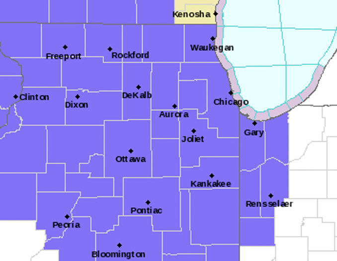
31, 2023; Hazardous Weather Outlook (tan), and Small Craft Advisory (gray) (NWS Chicago).
The activation of a Winter Weather Advisory ranges from 9:00 p.m. Saturday, December 30, 2023 in northwest Illinois to 4:00 a.m. Sunday, December 31, 2023 near Arlington Heights, and continues until noon Sunday.
ICE
Arlington Heights could see ice accumulation of about 0.03 inch between 12:00 a.m and 11:00 a.m. Sunday.
SNOW
Arlington Heights could see snow accumulation of about 0.5 inch on grass surfaces and elevated cold surfaces from about 6:00 a.m. to 11:00 p.m. Sunday.
Surface temperatures are most likely to be below freezing at the onset of precipitation overnight in interior northern Illinois, so freezing drizzle is more likely than drizzle. Surface temperatures will be close enough to freezing across Chicagoland and northern Illinois, so forecasters can’t truly rule out freezing drizzle occurring anywhere with the exception of maybe the locations within the footprint of the Chicago metro urban heat island, according to the National Weather Service Office Chicago.
The crossover to freezing and below freezing in Arlington Heights is likely to occur between 2:00 am. and 5:00 a.m., but bridges and overpasses will likely freeze before 2:00 a.m.
Key messages through Sunday night…
Freezing drizzle at the onset of a moderate winter storm system occurring Saturday night, and very early Sunday morning. There is about a 20% chance that a brief period of drizzle or freezing drizzle occurs prior to the onset of snow overnight, with the best chances for freezing drizzle being in interior northern Illinois.
Periods of light snow, snow showers, and flurries are likely on Sunday/New Year`s Eve. The best chances (50-70%) for minor snow accumulations (dusting to an inch) are expected roughly along a line just north of Rochelle, IL to Rensselaer, Indiana.
Wind gusts will peak to about 24 MPH between 8:00 p.m. and 10:00 p.m. Sunday – around the time the higher snow shower rates within the system will be diminishing.
Lake effect snow showers are expected to linger Sunday night into Monday morning, primarily into portions of northwest Indiana where a 50-70% chance for additional snow accumulations up to an inch or two exists.
Weather Radar in northeast Illinois was clear at 8:39 PM Saturday, December 30, 2023.
See also Arlingtoncardinal.com/clouds
Light precip. develops tonight. Psbl it begins as a little freezing drizzle, mainly across NW Illinois. Snow showers expected for Sun. but little/no road accumulations during the day. Lake effect continues into NW IN Sun. night. #ILwx #INwx pic.twitter.com/tFPQUr8QFX
— NWS Chicago (@NWSChicago) December 30, 2023
O’HARE FORECAST …
Saturday Night: Periods of freezing drizzle, mainly after 3am. Cloudy, with a low around 30. West southwest wind 5 to 10 mph.
Sunday: Periods of snow and freezing drizzle, becoming all snow after 3pm. High near 34. West wind 5 to 15 mph, with gusts as high as 20 mph. Chance of precipitation is 80%. Little or no ice accumulation expected. New snow accumulation of less than a half inch possible.
Sunday Night: A 50 percent chance of snow, mainly before midnight. Mostly cloudy, with a low around 28. North northwest wind 10 to 15 mph, with gusts as high as 25 mph.
New Year’s Day: Sunny, with a high near 36. North northwest wind 5 to 10 mph becoming west in the afternoon.
Monday Night: Mostly clear, with a low around 27. West southwest wind 5 to 15 mph, with gusts as high as 20 mph.
Tuesday: Mostly sunny, with a high near 39. Breezy.
Tuesday Night: Mostly cloudy, with a low around 29.
Wednesday: Mostly cloudy, with a high near 36.
Wednesday Night: Mostly cloudy, with a low around 24.
Thursday: Mostly sunny, with a high near 33.
Thursday Night: Partly cloudy, with a low around 23.
Friday: Mostly sunny, with a high near 36.
Friday Night: Mostly cloudy, with a low around 27.
Saturday: Partly sunny, with a high near 40.
LAKE TEMPS …
SOUTHERN LAKE MICHIGAN WATER TEMPERATURES
NATIONAL WEATHER SERVICE CHICAGO/ROMEOVILLE IL
904 AM CST Sat Dec 30 2023
LAKE MICHIGAN WATER TEMPERATURES…
CHICAGO SHORE………..40.
CHICAGO CRIB…………40.
MICHIGAN CITY………..42.
SOUTH MID LAKE BUOY…..43.
NORTH MID LAKE BUOY…..42.
&&
M IS FOR MISSING DATA THAT IS NORMALLY AVAILABLE.
THE MICHIGAN CITY WATER TEMPERATURE SENSOR IS LOCATED AT
A WATER INTAKE ONE MILE OFFSHORE AND 60 FEET BELOW THE
WATER SURFACE. IT IS READ EVERY DAY OF THE YEAR.
FOR LAKE MICHIGAN WATER LEVELS, PLEASE SEE:
WWW.LRE.USACE.ARMY.MIL/MISSIONS/GREAT-LAKES-INFORMATION/GREAT-LAKES-WATER-LEVELS/WATER-LEVEL-FORECAST/WEEKLY-GREAT-LAKES-WATER-LEVELS
december.chicagoweatherstation.com
Chicago Weather Forecast for your MAC/PC/TABLET includes surrounding suburbs.
^^ MOBILE? USE VOICE MIC ^^
facebook …
Please ‘LIKE’ the ‘Arlington Cardinal Page. See all of The Cardinal Facebook fan pages at Arlingtoncardinal.com/about/facebook …
Help fund The Cardinal Arlingtoncardinal.com/sponsor
20240105-1435future
