
Peak thunderstorm activity for northern Illinois is set at 12:00 a.m. to 5:00 a.m. Sunday, May 7, 2023; and although hail is possible overnight, NWS Chicago forecasters expect “lower coverage and/or intensity of storms in northern Illinois overnight.”
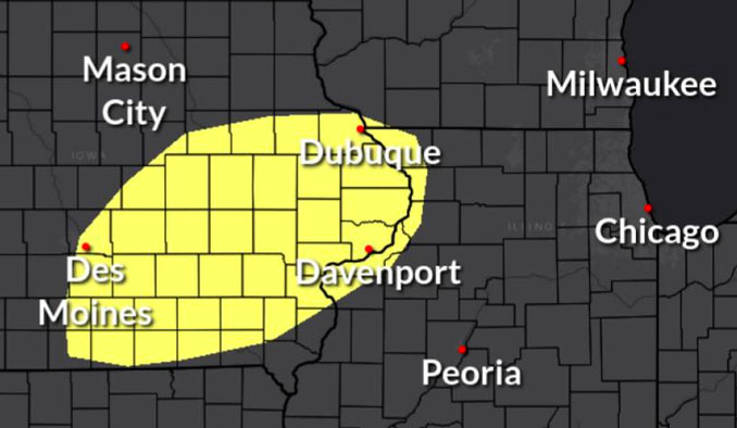
Scattered thunderstorms from northern Missouri to southern Iowa will move into central Illinois after midnight. The strongest storms may produce damaging winds and hail, with the highest coverage southwest of a line from Mendota to Paxton.
NORTHERN ILLINOIS …
Worst Case Scenario
Limited Hail Risk…up to ping pong size.
Limited Damaging Wind Risk…up to 65 mph.
Limited Flooding Risk.
Likely Scenario
Moderate showers with a little thunder
The significant images of regional satellite and radar imagery depict a compact region of scattered elevated thunderstorms near Bloomington and Gibson City, which are gradually moving east-northeast at 35 mph. Recent RAP guidance (model guidance) suggests the thunderstorms are being maintained by low-level convergence at the nose of a 40-45kt 925-850mb low-level jet. After sunset, the low-level jet should intensify encouraging a gradual uptick in coverage of scattered thunderstorms into northeastern Illinois and northwestern Indiana (along and east of I-55). Conditions support occasional production of pea to penny size hail and lightning strikes as the thunderstorms continue east-northeastward. However, these thunderstorms are not the focus for the overnight period for the NWS Chicago office.
A cluster of supercells continues to move eastward just south of the Iowa/Missouri border near an effective warm front modified by a complex of storms that moved through central Illinois earlier today. With recent satellite imagery depicting increasing updraft vigor and width with each supercell, it seems plausible they will “grow upscale” into a compact complex over the next few hours and at least partially intercept the intensifying low-level jet as they move into central Illinois.
In summary, additional thunderstorm development to the north and near the Quad Cities may be less organized and in lower coverage, leading to a lower coverage and/or intensity of storms in northern Illinois overnight. However, even with a lower coverage and perhaps less organization to thunderstorms locally overnight, steep mid-level lapse rates will still support a damaging hail threat. The peak thunderstorm window remains roughly midnight to 5 am.
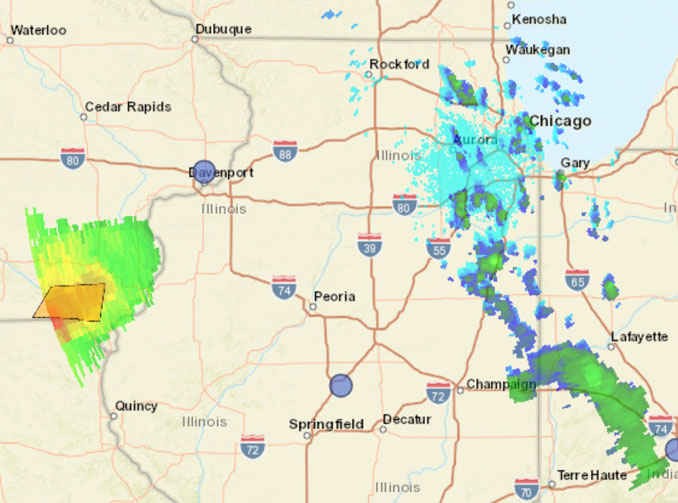
Weather Radar indicates some showers with a little thunder moving from Kane County into northwest Cook County, McHenry County and Lake County.
See also Arlingtoncardinal.com/clouds
O’HARE FORECAST …
Saturday Night: Scattered showers and thunderstorms, mainly between 1am and 5am. Some of the storms could produce heavy rainfall. Mostly cloudy, with a low around 63. South southeast wind around 10 mph, with gusts as high as 20 mph. Chance of precipitation is 50%.
Sunday: Mostly sunny, with a high near 82. West southwest wind 5 to 15 mph becoming northeast in the afternoon.
Sunday Night: Showers and thunderstorms likely, mainly after 1am. Increasing clouds, with a low around 53. East northeast wind 5 to 10 mph. Chance of precipitation is 70%. New rainfall amounts between a half and three quarters of an inch possible.
Monday: Scattered showers and thunderstorms before 1pm. Mostly cloudy, with a high near 68. East northeast wind around 10 mph. Chance of precipitation is 30%.
Monday Night: A chance of showers and thunderstorms. Mostly cloudy, with a low around 53. North northeast wind 5 to 10 mph. Chance of precipitation is 50%.
Tuesday: Partly sunny, with a high near 68.
Tuesday Night: Partly cloudy, with a low around 49.
Wednesday: Sunny, with a high near 71.
Wednesday Night: Partly cloudy, with a low around 52.
Thursday: Mostly sunny, with a high near 75.
Thursday Night: Mostly cloudy, with a low around 57.
Friday: A chance of showers. Mostly cloudy, with a high near 77.
Friday Night: A chance of showers. Mostly cloudy, with a low around 59.
Saturday: A chance of showers. Partly sunny, with a high near 79.
LAKE TEMPS …
SOUTHERN LAKE MICHIGAN WATER TEMPERATURES
NATIONAL WEATHER SERVICE CHICAGO/ROMEOVILLE IL
901 AM CDT Sat May 6 2023
LAKE MICHIGAN WATER TEMPERATURES…
CHICAGO SHORE……….51.
CHICAGO CRIB………..48.
WAUKEGAN BUOY……….48.
WINTHROP HARBOR BUOY……….46.
MICHIGAN CITY……….46.
&&
M IS FOR MISSING DATA THAT IS NORMALLY AVAILABLE.
THE MICHIGAN CITY WATER TEMPERATURE SENSOR IS LOCATED AT A WATER
INTAKE ONE MILE OFFSHORE AND 60 FEET BELOW WATER SURFACE. IT IS READ
EVERY DAY OF THE YEAR.
Chicago Weather Forecast for your MAC/PC/TABLET includes surrounding suburbs.
^^ MOBILE? USE VOICE MIC ^^
facebook …
Please ‘LIKE’ the ‘Arlington Cardinal Page. See all of The Cardinal Facebook fan pages at Arlingtoncardinal.com/about/facebook …
Help fund The Cardinal Arlingtoncardinal.com/sponsor
20240105-1435future
