
Light snow accumulations with accumulation up to two inches in some areas of northwest Illinois are forecast from Saturday night into Sunday with slippery travel possible. Snow accumulation in Arlington Heights and nearby communities is likely to be 0.8 inches or less in the period from 12:00 a.m. Saturday/Sunday to about 10:00 a.m. to 12:00 p.m. Sunday. Snow flurries are likely to begin about 9:00 p.m. Saturday in Arlington Heights. The snow accumulation forecast has trended downward in the past 12 hours, therefore total accumulation in Arlington Heights will likely be less than 0.8 inch — maybe even less than 0.5 inch. Accumulation may be even less on paved surfaces.
Northwest Wisconsin is on target for around 20 inches of snow accumulation with snow accumulation totals being less than an inch in most of northeast Illinois and near two inches in northwest Illinois. Motorists traveling from northeast Illinois to northwest Wisconsin will face a deepening gradient of snow as they approach the center storm track over northwest Wisconsin.
There is one week left of the normal daily low temperature bottomed out at 16°F, and we have been well above the normal low each day in January 2023. The normal daily high increases from 31°F to 32°F in ten days. Two minutes of daylight were gained Friday and Saturday as Winter 2022-2023 progresses to the second half of winter.
Saturday the high temperature near Arlington Heights is forecast at 32°F from 9:00 p.m. through midnight. The 32°F temperature will continue into Sunday until 1:00 a.m., and will hold at about 31°F until the light snowy period ends around 8:00 a.m. to 10:00 a.m. Sunday.
The next snowy period is likely to begin around 12:00 a.m. Tuesday/Wednesday, but this storm track is currently forecast to pass south of Chicagoland with the southern third of Chicagoland possibly affected the most by this snow storm.
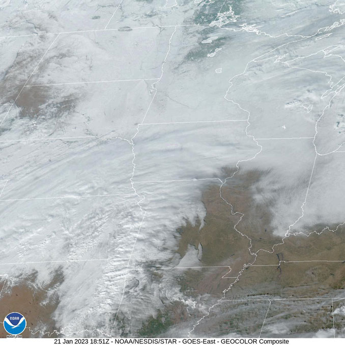
Weather Radar in northeast Illinois was clear at 12:30 p.m.
See also Arlingtoncardinal.com/clouds
Snow will overspread much of the region late this evening and overnight leading to slippery travel, particularly on elevated or untreated road surfaces. The main window for lightly accumulating snow is roughly 11 PM tonight through noon on Sunday. #ILwx #INwx pic.twitter.com/5d40bbqvrF
— NWS Chicago (@NWSChicago) January 21, 2023
Clouds will largely continue through the weekend with highs near normal. Some snow on the way for Sat night and Sun A.M., with a coating to 2 inches most probable, that will likely result in some slick roads. Also keeping an eye on a system in the middle of next week. #ILwx #INwx pic.twitter.com/KGQ6LKj89d
— NWS Chicago (@NWSChicago) January 20, 2023
O’HARE FORECAST …
Saturday Afternoon: Cloudy, with a high near 31. Southwest wind around 5 mph, with gusts as high as 10 mph.
Saturday Night: Snow likely, mainly after midnight. Cloudy, with a low around 30. South southwest wind around 5 mph becoming calm after midnight. Chance of precipitation is 70%. New snow accumulation of less than a half inch possible.
Sunday: Snow likely, mainly before 9am. Cloudy, with a high near 34. Calm wind becoming north northwest around 5 mph in the afternoon. Chance of precipitation is 60%. New snow accumulation of less than a half inch possible.
Sunday Night: Cloudy during the early evening, then gradual clearing, with a low around 24. Northwest wind 5 to 10 mph.
Monday: Sunny, with a high near 35. Breezy, with a west southwest wind 5 to 10 mph increasing to 15 to 20 mph in the afternoon. Winds could gust as high as 30 mph.
Monday Night: Mostly cloudy, with a low around 28. Breezy.
Tuesday: Mostly cloudy, with a high near 36.
Tuesday Night: A chance of snow after midnight. Cloudy, with a low around 30.
Wednesday: Snow likely, mainly before noon. Cloudy, with a high near 34.
Wednesday Night: Cloudy, with a low around 21.
Thursday: Cloudy, with a high near 29.
Thursday Night: Mostly cloudy, with a low around 18.
Friday: Mostly cloudy, with a high near 28.
LAKE TEMPS …
SOUTHERN LAKE MICHIGAN WATER TEMPERATURES
NATIONAL WEATHER SERVICE CHICAGO/ROMEOVILLE IL
905 AM CST Sat Jan 21 2023
LAKE MICHIGAN WATER TEMPERATURES…
CHICAGO SHORE……….36.
CHICAGO CRIB……….35.
MICHIGAN CITY……….36.
&&
M IS FOR MISSING DATA THAT IS NORMALLY AVAILABLE.
THE MICHIGAN CITY WATER TEMPERATURE SENSOR IS LOCATED AT A WATER
INTAKE ONE MILE OFFSHORE AND 60 FEET BELOW WATER SURFACE. IT IS READ
EVERY DAY OF THE YEAR.
january.chicagoweatherstation.com
Chicago Weather Forecast for your MAC/PC/TABLET includes surrounding suburbs.
^^ MOBILE? USE VOICE MIC ^^
facebook …
Please ‘LIKE’ the ‘Arlington Cardinal Page. See all of The Cardinal Facebook fan pages at Arlingtoncardinal.com/about/facebook …
Help fund The Cardinal Arlingtoncardinal.com/sponsor
20240105-1435future
