
A major storm system affecting the area is forecast for Thursday through Saturday, with the most significant impacts from accumulating and blowing snow and very strong winds predicted for late Thursday afternoon into Friday night. Blizzard conditions are possible for the entire Chicagoland are during this time.
Dangerous, bitter cold is forecast for Christmas Eve and Christmas Day, according to the National Weather Service. Impacts from this cold may be exacerbated if the late week storm produces a large number of power outages.
Although it is too early to count on storm accumulation predictions, both the ECMWF (European model) and the GFS (United States National Weather Service model) predict the deepest snow accumulations will occur north of Chicagoland near north-central Wisconsin and northwest Wisconsin. In other words, it currently looks as though the deepest snow-producing part of the snow storm system will pass to our northwest.
The ECMWF is indicating about 7 inches of snow accumulation for Arlington Heights and nearby communities, while about 16 or 17 inches of snow accumulation is indicated for north-central and northwest Wisconsin.
The GFS is indicating only about 1 inch of snow accumulation for Arlington Heights and nearby communities, while about 4 to 5 inches are predicted for southern Minnesota and north-central and northwest Wisconsin.
Of course, the track could move to a more southerly path, but our main concerns for now appear to involve preparation for low or significant snow accumulations with high wind conditions with blowing snow. The blowing snow will affect travel, and high winds with snow load on tree branches and power lines may cause power outages during a period of severe cold through Christmas Day Sunday.
Weather Radar shows light precipitation northwest and north-central Illinois, but the precipitation is not related to the severe weather coming Thursday afternoon to Friday night.
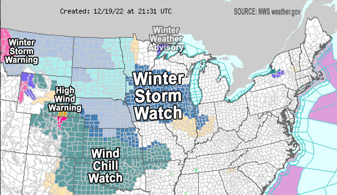
WINTER STORM WATCH …
Winter Storm Watch URGENT – WINTER WEATHER MESSAGE National Weather Service Chicago IL 230 PM CST Mon Dec 19 2022
COUNTIES: Winnebago-Boone-McHenry-Lake IL-Ogle-Lee-De Kalb-Kane-DuPage- La Salle-Kendall-Grundy-Kankakee-Livingston-Iroquois-Ford- Northern Cook-Central Cook-Southern Cook-Northern Will- Southern Will-Eastern Will-Lake IN-Porter-Newton-Jasper-Benton-
Including the cities/villages of Arlington Heights, Rockford, Belvidere, Crystal Lake, Algonquin, McHenry, Woodstock, Waukegan, Buffalo Grove, Mundelein, Gurnee, Rochelle, Oregon, Byron, Dixon, DeKalb, Sycamore, Aurora, Elgin, Naperville, Wheaton, Downers Grove, Lombard, Carol Stream, Ottawa, Streator, La Salle, Mendota, Marseilles, Oswego, Yorkville, Plano, Morris, Coal City, Minooka, Kankakee, Bourbonnais, Bradley, Pontiac, Dwight, Fairbury, Watseka, Gilman, Paxton, Gibson City, Evanston, Des Plaines, Schaumburg, Palatine, Northbrook, Chicago, Cicero, Oak Lawn, Oak Park, La Grange, Calumet City, Oak Forest, Lemont, Orland Park, Park Forest, Joliet, Bolingbrook, Plainfield, Mokena, Channahon, Manhattan, Wilmington, Crete, Peotone, Beecher, Gary, Hammond, Merrillville, Portage, Valparaiso, Chesterton, Roselawn, Kentland, Morocco, Rensselaer, DeMotte, Fowler, and Oxford 230 PM CST Mon Dec 19 2022 /330 PM EST Mon Dec 19 2022/
…WINTER STORM WATCH IN EFFECT FROM THURSDAY EVENING (12/22/22) THROUGH LATE FRIDAY NIGHT (12/23/22)…
* WHAT…Blizzard conditions possible. Winds could gust as high as 55 mph.
* WHERE…Portions of central, east central, north central and northeast Illinois and northwest Indiana.
* WHEN…From Thursday evening through late Friday night.
* IMPACTS…Falling and blowing snow may result in white out conditions with zero visibility at times, making travel extremely difficult, if not impossible. Power outages will also be possible as a result of strong damaging wind gusts to 55 mph.
* ADDITIONAL DETAILS…Bitterly cold wind chills as low as 25 below zero are likely during the height of the storm. Wind chills of this magnitude can cause frostbite on exposed skin in as little as 30 minutes.
PRECAUTIONARY/PREPAREDNESS ACTIONS…
Prepare for possible blizzard conditions. Continue to monitor the latest forecasts for updates on this situation.
See also Arlingtoncardinal.com/clouds
[4:10 AM 12/19] Fairly quiet today, with a chance for some light snow tonight. Attention turns to the Thursday to Saturday timeframe with significant impacts from a winter storm looking increasingly likely. #ILwx #INwx pic.twitter.com/fiHlOkvmdG
— NWS Chicago (@NWSChicago) December 19, 2022
O’HARE FORECAST …
Monday Afternoon: Mostly cloudy, with a steady temperature around 24. Southwest wind around 5 mph becoming southeast.
Tonight: A chance of flurries between 7pm and 3am. Cloudy, with a low around 23. East southeast wind around 5 mph becoming south after midnight. Winds could gust as high as 10 mph.
Tuesday: Mostly cloudy, with a high near 32. South wind 5 to 10 mph becoming north northwest in the afternoon.
Tuesday Night: Partly cloudy, with a low around 14. North northwest wind around 5 mph, with gusts as high as 10 mph.
Wednesday: Mostly cloudy, with a high near 29. North wind around 5 mph becoming east southeast in the afternoon. Winds could gust as high as 10 mph.
Wednesday Night: A 30 percent chance of snow after midnight. Cloudy, with a low around 26.
Thursday: A chance of snow before noon, then rain and snow. High near 34. Chance of precipitation is 100%.
Thursday Night: Snow. The snow could be heavy at times. Widespread blowing snow after midnight. Cloudy, with a low around 7. Breezy.
Friday: Snow. The snow could be heavy at times. Widespread blowing snow. Cloudy, with a high near 11. Windy.
Friday Night: A chance of snow before midnight. Widespread blowing snow. Mostly cloudy, with a low around 3. Windy.
Saturday: Areas of blowing snow. Mostly cloudy, with a high near 11. Breezy.
Saturday Night: Partly cloudy, with a low around -1. Breezy.
Christmas Day: Mostly sunny, with a high near 12.
LAKE TEMPS …
SOUTHERN LAKE MICHIGAN WATER TEMPERATURES
NATIONAL WEATHER SERVICE CHICAGO/ROMEOVILLE IL
851 AM CST Mon Dec 19 2022
LAKE MICHIGAN WATER TEMPERATURES…
CHICAGO SHORE……….36.
CHICAGO CRIB……….36.
MICHIGAN CITY……….40.
&&
M IS FOR MISSING DATA THAT IS NORMALLY AVAILABLE.
THE MICHIGAN CITY WATER TEMPERATURE SENSOR IS LOCATED AT A WATER
INTAKE ONE MILE OFFSHORE AND 60 FEET BELOW WATER SURFACE. IT IS READ EVERY DAY OF THE YEAR.
december.chicagoweatherstation.com
Chicago Weather Forecast for your MAC/PC/TABLET includes surrounding suburbs.
^^ MOBILE? USE VOICE MIC ^^
facebook …
Please ‘LIKE’ the ‘Arlington Cardinal Page. See all of The Cardinal Facebook fan pages at Arlingtoncardinal.com/about/facebook …
Help fund The Cardinal Arlingtoncardinal.com/sponsor
20240105-1435future
