There is limited snow risk Wednesday night in northwest Illinois (west of I-39) before a winter storm moves into northern Illinois Thursday. Snow flurries or light snow is forecast to begin in Arlington Heights after midnight Wednesday/Thursday. Then the snowfall rate intensity is forecast to intensify after 5:00 a.m. Thursday, December 22, 2022, and significant snowfall is forecast to continue until about 5:00 p.m. Friday.
The peak snowfall rates near Arlington Heights are forecast between 10:00 a.m. and 11:00 p.m. Thursday.
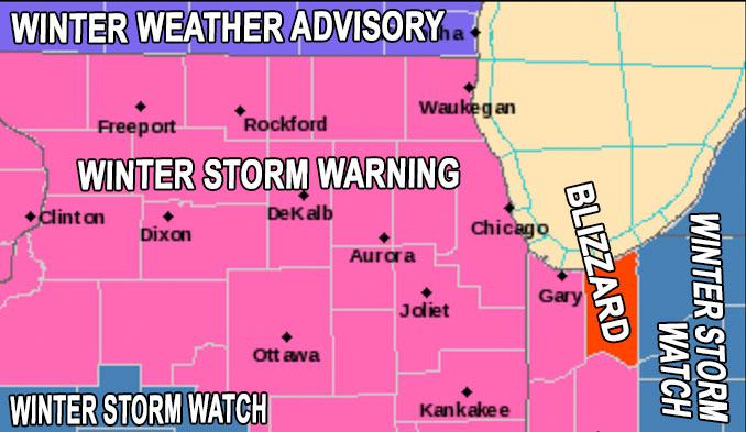
WINTER STORM WARNING: Major storm system affecting the area Thursday through Saturday, with the most significant impacts of accumulating and blowing snow and very strong winds occurring late Thursday afternoon into Friday night.
High winds and extreme cold are the highlight hazards of the approaching winter storm for Thursday and Friday — even more so because snow accumulations continue to trend downward for Arlington Heights and nearby northwest communities. With a low around -4 Friday morning, wind chill is forecast down to -31°F from 6 am to 7 am. Wind Chill at the Chicago Bears game Saturday, Christmas Eve at the 12 p.m. kickoff is forecast at -10°F with wind gusts at 34 MPH.
The impact of this winter storm will more likely involve high winds; severe cold; dangerous travel especially on rural roads with risks of blowing snow and drifts and being stranded and then exposed to severe cold. Although, snow depth may be significant, the snow depth hazard may be less of a concern, compared to the wind and cold hazards. However, it will be best to get driveways clear of the first period of wet snow by 11:00 a.m. Thursday when the temperature is around 31°F, because the rapid drop to 0°F by midnight might leave you with the hard crunch of frozen wet snow and ice under deep, dry powdery snow that falls after 11:00 a.m. Thursday.
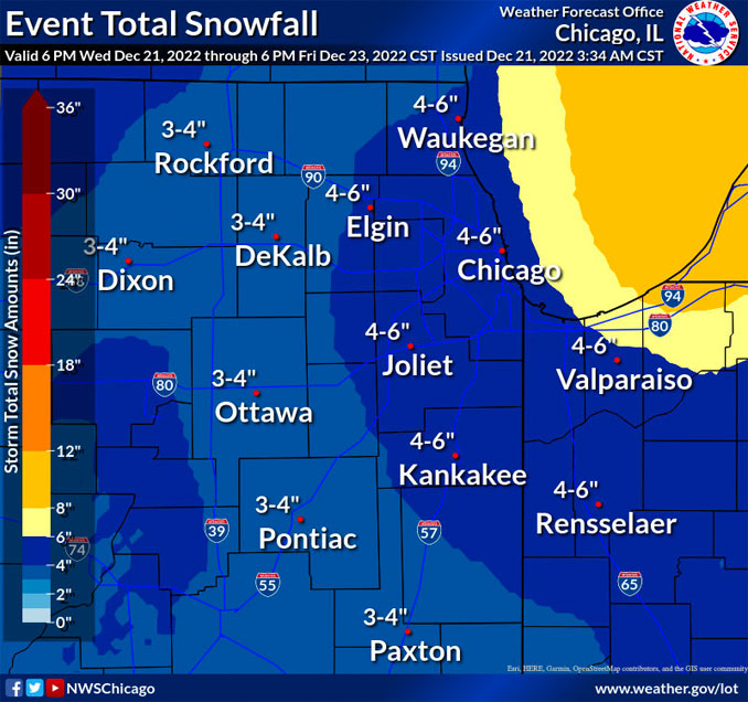
CARDINAL NEWS WINTER STORM WEATHER FORECAST: Snow accumulation for O’Hare, Arlington Heights and nearby communities will likely be no more than 4.6 inches from 6:00 a.m. Thursday to 5:00 p.m. Friday. The snowfall accumulation may only fall in the 2.0 to 3.5-inch range. However, winds up to 50 MPH from 11:00 a.m. to 4:00 p.m. accompanying the snowfall may cause some serious problems with power lines, with the potential to be serious since air temperature will be around 0°F when these winds occur, and heating of homes may be at risk. Repairs may be delayed because of safety restrictions for ComEd workers on elevated platforms during high winds. Wind gusts aren’t forecast to calm down under 30 mph until 5:00 p.m. Saturday (Christmas Eve).
WINTER STORM WARNING: Major storm system affecting the area Thursday through Saturday, with the most significant impacts of accumulating and blowing snow and very strong winds occurring late Thursday afternoon into Friday night.
Additional weather hazards include severe cold — a low of -4°F Friday morning with a high of 0°F Friday, and then a low of -2°F Saturday morning with a high near 9°F Saturday. The forecast low for Christmas morning (Sunday morning) is -1°F.
Wind Chill is forecast to be well below zero from 5:00 p.m. Thursday (-9°F) through 11:00 a.m. Sunday (-8°F).
Weather Radar in northeast Illinois was clear at 10:45 a.m., but there is precipitation approaching in northeasts Iowa.
See also Arlingtoncardinal.com/clouds
WINTER STORM WARNING …
URGENT – WINTER WEATHER MESSAGE National Weather Service Chicago IL 1041 AM CST Wed Dec 21 2022
COUNTIES: Lake IL-DuPage-Kankakee-Iroquois-Ford-Northern Cook-Central Cook- Southern Cook-Northern Will-Southern Will-Eastern Will- Including the cities of Arlington Heights, Waukegan, Buffalo Grove, Mundelein, Gurnee, Naperville, Wheaton, Downers Grove, Lombard, Carol Stream, Kankakee, Bourbonnais, Bradley, Watseka, Gilman, Paxton, Gibson City, Evanston, Des Plaines, Schaumburg, Palatine, Northbrook, Chicago, Cicero, Oak Lawn, Oak Park, La Grange, Calumet City, Oak Forest, Lemont, Orland Park, Park Forest, Joliet, Bolingbrook, Plainfield, Mokena, Channahon, Manhattan, Wilmington, Crete, Peotone, and Beecher 1041 AM CST Wed Dec 21 2022
…WINTER STORM WARNING IN EFFECT FROM NOON THURSDAY TO 6 AM CST SATURDAY…
* WHAT…Snow and blowing snow producing occasional white out conditions expected. Total snow accumulations of 2 to 5 inches. Winds gusting as high as 50 mph expected. Wind chill values of 25 to 35 below zero expected.
* WHERE…Portions of east central and northeast Illinois.
* WHEN…From noon Thursday to 6 AM CST Saturday.
* IMPACTS…Falling or blowing snow may result in white out conditions with zero visibility at times, making travel extremely difficult. Power outages will also be possible as a result of strong wind gusts to 50 mph. Roads will likely quickly become ice covered as temperatures rapidly fall Thursday afternoon.
* ADDITIONAL DETAILS…Dangerously cold wind chills as low as 25 to 35 below zero are likely Thursday night through Friday night. Wind chills of this magnitude can cause frostbite on exposed skin in as little as 20 minutes.
PRECAUTIONARY/PREPAREDNESS ACTIONS…
If you must travel, keep an extra flashlight, food, and water in your vehicle in case of an emergency.
The latest road conditions for Illinois can be obtained on the internet at www.gettingaroundillinois.com.
.In addition to falling and blowing snow, extreme cold will worsen the dangerous conditions Thu & Fri. Wind chills will drop to as low as 35 degrees below zero early Friday morning. Once the snow stops, dangerous cold will continue through the holiday weekend. #ILwx #INwx (5/5) pic.twitter.com/Ew0UXCT2e6
— NWS Chicago (@NWSChicago) December 21, 2022
O’HARE FORECAST …
Wednesday: Cloudy, with a high near 28. Northeast wind around 5 mph becoming east southeast in the afternoon. Winds could gust as high as 10 mph.
Wednesday Night: A chance of flurries between midnight and 3am, then a slight chance of snow after 3am. Cloudy, with a low around 28. South wind around 5 mph, with gusts as high as 20 mph. Chance of precipitation is 20%.
Thursday: Snow, mainly after 10am. Areas of blowing snow after 3pm. Temperature rising to near 33 by 9am, then falling to around 10 during the remainder of the day. Wind chill values as low as -9. Breezy, with a south wind 5 to 10 mph becoming west northwest 15 to 20 mph in the afternoon. Winds could gust as high as 35 mph. Chance of precipitation is 100%. New snow accumulation of 2 to 4 inches possible.
Thursday Night: Snow. Widespread blowing snow, mainly after midnight. Low around -4. Wind chill values as low as -30. Windy, with a west northwest wind 20 to 30 mph, with gusts as high as 45 mph. Chance of precipitation is 80%. New snow accumulation of less than one inch possible.
Friday: Scattered snow showers. Widespread blowing snow. Cloudy and cold, with a high near 0. Windy, with a west wind around 30 mph, with gusts as high as 50 mph. Chance of precipitation is 50%.
Friday Night: Isolated snow showers before midnight, then scattered flurries after midnight. Widespread blowing snow. Mostly cloudy, with a low around -2. Breezy. Chance of precipitation is 20%.
Saturday: Areas of blowing snow. Mostly sunny and cold, with a high near 9. Breezy.
Saturday Night: Mostly clear, with a low around -1.
Christmas Day: Sunny, with a high near 13.
Sunday Night: A chance of snow. Mostly cloudy, with a low around 8.
Monday: Mostly cloudy, with a high near 23.
Monday Night: Mostly cloudy, with a low around 8.
Tuesday: Partly sunny, with a high near 22.
SouthLakeMichiganDataPASTEHERE
december.chicagoweatherstation.com
Chicago Weather Forecast for your MAC/PC/TABLET includes surrounding suburbs.
^^ MOBILE? USE VOICE MIC ^^
facebook …
Please ‘LIKE’ the ‘Arlington Cardinal Page. See all of The Cardinal Facebook fan pages at Arlingtoncardinal.com/about/facebook …
Help fund The Cardinal Arlingtoncardinal.com/sponsor
20240105-1435future
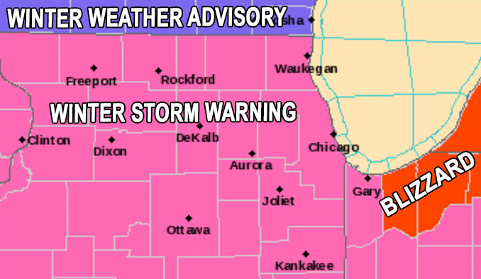
This map was updated to top map within about 30 minutes of being issued …