
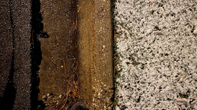
There has been light snow, mist and fog since about 3:25 a.m. in central Arlington Heights. The snow began to show accumulation on grassy areas about 3:50 a.m. Paved surfaces at 4:15 a.m. remain wet without snow accumulating, but elevated surfaces on bridges and overpasses may be slick.
The snow depth forecast for roadways is highly uncertain. According to NWS Chicago, the QPF (Quantitative Precipitation Forecast) is significant and lake-enhancement snow is expected to develop mid-morning and continue into the afternoon. However, warm lake temperatures (most lake temperatures are in the 50s), and warm marginal inland surface temperatures of 32°F to 34°F are factors that will melt snow landing on paved surfaces. Furthermore, areas near O’Hare and Arlington Heights may reach a high temperature of 36°F from 11:00 a.m. to 5:00 p.m. so the mid-day period of time is less likely to accumulate snow. If snow is going to accumulate on roadways and driveway, most of the accumulation will occur between 6:00 a.m. and 11:00 a.m. (1.1 inch), and then 6:00 p.m. to midnight (1.4 inch). Followed by 1 inch after midnight. One-half inch might accumulate on grassy areas only between 12 p.m. and 6:00 p.m. while snow is mixed with rain.
Blowing snow won’t be much of a factor as the snow will be very wet, and winds will be below 10 MPH most of the day.
High snowfall rates of 1 inch per hour that overwhelm the snow-melting factors are possible this afternoon. High snowfall rates could bring significant accumulation on roadways if it develops and overwhelms the melting factors. However, winds from the lake are not forecast to be that strong. The CARDINAL NEWS bet is on insignificant snow on pavement in Arlington Heights, and slushy accumulation on the grass.
Areas in Lake County, such as Antioch; and McHenry County, such as the City of McHenry especially, will probably not experience the “low accumulation period” from 11:00 a.m. to 500 p.m. Snow accumulation on paved surfaces may continue uninterrupted throughout the day. These areas may see greater accumulation — especially McHenry with a forecast high of only 34°F from 2:00 p.m. to 3:00 p.m.
Weather Radar shows significant precipitation over all of northern Illinois in bands moving southeast to northwest (low pressure over the Florida panhandle and high pressure over Ontario, Canada is bringing us air flow from the east). Winds are forecast to shift from east to northwest by 8:00 p.m.
Weather Radar in northeast Illinois was clear.
See also Arlingtoncardinal.com/clouds
Gusty snow showers Wed across much of the area. Temperatures near or above freezing, but patchy slick spots are possible under heavier snow, along with sharply reduced visibilities. Accumulating lake effect snow is also expected, mainly in Lake & Porter Counties in NW Indiana. pic.twitter.com/8bXPH99vMh
— NWS Chicago (@NWSChicago) November 15, 2022
[3:50 AM 11/15] Slippery travel develops this AM as snow overspreads the area. Lake-effect snow showers persist across far NE Illinois this PM & evening and will result in continued impacts to the PM & evening commutes. Plan ahead and allow for extra travel time! #ILwx #INwx pic.twitter.com/2aKhpzXRsL
— NWS Chicago (@NWSChicago) November 15, 2022
URGENT – WINTER WEATHER MESSAGE
(Winter Weather Advisory)
National Weather Service Chicago IL
230 AM CST Tue Nov 15 2022
McHenry-Lake IL-DuPage-Northern Cook-Central Cook- Including the cities of Crystal Lake, Algonquin, McHenry, Woodstock, Waukegan, Buffalo Grove, Mundelein, Gurnee, Naperville, Wheaton, Downers Grove, Lombard, Carol Stream, Evanston, Des Plaines, Schaumburg, Palatine, Northbrook, Chicago, Cicero, Oak Lawn, Oak Park, and La Grange 230 AM CST Tue Nov 15 2022
…WINTER WEATHER ADVISORY REMAINS IN EFFECT FROM 6 AM THIS MORNING TO 6 AM CST WEDNESDAY…
* WHAT…Periods of snow, including lake effect snow showers, with slushy accumulations on roadways expected. Total snow accumulations of 2 to 5 inches. Locally higher amounts near 6 inches are possible across interior portions of Lake, northwest Cook, and McHenry counties. Limited snow accumulations are expected along the immediate Lake Michigan shoreline.
* WHERE…McHenry, Lake IL, DuPage, Northern Cook and Central Cook Counties.
* WHEN…From 6 AM this morning to 6 AM CST Wednesday.
* IMPACTS…Plan on slippery road conditions including during parts of this morning`s and evening commutes.
* ADDITIONAL DETAILS…Snow rates may exceed 1 inch per hour from late this afternoon to early Wednesday morning due to lake effect snow showers.
PRECAUTIONARY/PREPAREDNESS ACTIONS…
Slow down and use caution while traveling.
The latest road conditions for Illinois can be obtained on the internet at www.gettingaroundillinois.com.
O’HARE FORECAST …
Overnight: A 30 percent chance of snow, mainly after 5am. Cloudy, with a low around 32. East wind around 5 mph.
Tuesday: Snow before 3pm, then snow, possibly mixed with rain. High near 36. East wind 5 to 10 mph. Chance of precipitation is 100%. New snow accumulation of 1 to 2 inches possible.
Tuesday Night: Snow, possibly mixed with rain, becoming all snow after 7pm. Low around 32. Northeast wind around 5 mph becoming west northwest in the evening. Chance of precipitation is 90%. New snow accumulation of 1 to 3 inches possible.
Wednesday: Snow showers likely before 1pm, then snow showers likely, possibly mixed with rain between 1pm and 4pm, then snow showers likely after 4pm. Cloudy, with a high near 36. West northwest wind 5 to 10 mph, with gusts as high as 15 mph. Chance of precipitation is 60%. New snow accumulation of less than one inch possible.
Wednesday Night: Snow showers likely before 7pm, then flurries with a chance of snow showers between 7pm and 1am, then flurries after 1am. Mostly cloudy, with a low around 26. West wind around 10 mph, with gusts as high as 15 mph. Chance of precipitation is 60%.
Thursday: Flurries, mainly before 7am, then a slight chance of snow showers after 1pm. Mostly cloudy, with a high near 33. Chance of precipitation is 20%.
Thursday Night: A 30 percent chance of snow showers, mainly between 7pm and 1am. Mostly cloudy, with a low around 18.
Friday: Mostly cloudy, with a high near 25.
Friday Night: Mostly cloudy, with a low around 14.
Saturday: Partly sunny, with a high near 28.
Saturday Night: Partly cloudy, with a low around 14.
Sunday: Mostly sunny, with a high near 27.
Sunday Night: Mostly clear, with a low around 18.
Monday: Mostly sunny, with a high near 35.
LAKE TEMPS …
SOUTHERN LAKE MICHIGAN WATER TEMPERATURES
NATIONAL WEATHER SERVICE CHICAGO/ROMEOVILLE IL
907 AM CST Mon Nov 14 2022
LAKE MICHIGAN WATER TEMPERATURES…
CHICAGO SHORE……….55.
CHICAGO CRIB……….50.
WILMETTE BUOY……….50.
MICHIGAN CITY……….51.
MICHIGAN CITY BUOY……….50.
SOUTH MID LAKE BUOY……….50.
NORTH MID LAKE BUOY……….46.
&&
M IS FOR MISSING DATA THAT IS NORMALLY AVAILABLE.
THE MICHIGAN CITY WATER TEMPERATURE SENSOR IS LOCATED AT A WATER
INTAKE ONE MILE OFFSHORE AND 60 FEET BELOW WATER SURFACE. IT IS READ
EVERY DAY OF THE YEAR.
november.chicagoweatherstation.com
Chicago Weather Forecast for your MAC/PC/TABLET includes surrounding suburbs.
^^ MOBILE? USE VOICE MIC ^^
facebook …
Please ‘LIKE’ the ‘Arlington Cardinal Page. See all of The Cardinal Facebook fan pages at Arlingtoncardinal.com/about/facebook …
Help fund The Cardinal Arlingtoncardinal.com/sponsor
20240105-1435future
