

The NWS Chicago office expired the Winter Weather Advisory for Cook County and several other counties by 3:00 p.m. Tuesday, November 15, 2022. The Winter Weather Advisory initially continued for Lake, Kenosha, Walworth, and Racine counties, but at 7:00 p.m. Tuesday the Winter Weather Advisory was limited to Lake County, Illinois.
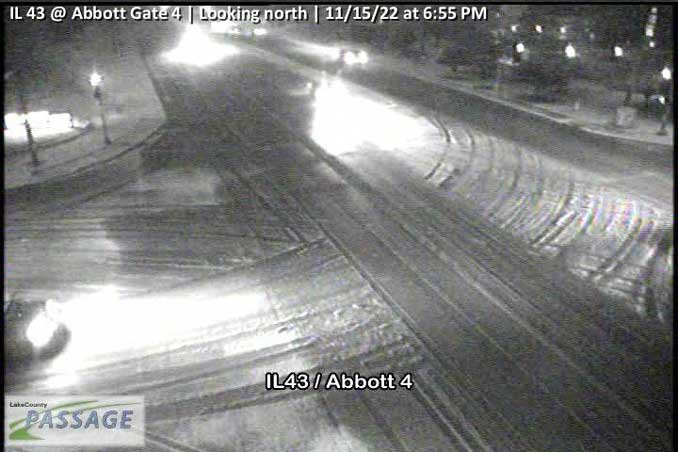
Many of the roadways in Lake County are wet with only a few that are snow-covered, according to images available on Lake County Passage traffic cameras. One of the roads with the most snow cover was Route 43 at Abbott Gate 4 near North Chicago and south of Gurnee.
The greatest snow amounts from this morning were observed in DuPage, Kendall, and western portions of Cook counties, where 2-3.5 inches of snow accumulated. Snowfall in Arlington Heights amounted to incomplete covering of grassy areas and little or no accumulation on any paved surfaces.
Temperatures along the Lake Michigan shoreline from Lake County to Cook County are 35°F while inland temperatures are 34°F even as far west as Rockford.
Weather Radar showed scattered light precipitation over northern Illinois with the heaviest precipitation visible near the Lake Michigan shoreline in Lake County. The lake effect snow bands are moving north to south.
See also Arlingtoncardinal.com/clouds
Lake-effect snow showers continue to fall on parts of Lake and northeastern Cook counties resulting in slushy accumulations on roads and poor visibilities. Use extra caution when driving under these snow showers. #ILwx pic.twitter.com/yYyuDyPPdG
— NWS Chicago (@NWSChicago) November 16, 2022
Starting to see snow accumulate on roadways directly underneath the lake effect snow band this afternoon. Plan on a longer commute this afternoon/evening up in Lake County, IL! Take it slow and increase following distance! (image courtesy of Lake County Passage) #ILwx https://t.co/bADDG27UYI pic.twitter.com/dLgxtAcB3X
— NWS Chicago (@NWSChicago) November 15, 2022
URGENT – WINTER WEATHER MESSAGE
National Weather Service Chicago IL
Issued by National Weather Service Lincoln IL
224 PM CST Tue Nov 15 2022
Lake IL- Including the cities of Waukegan, Buffalo Grove (Lake County), Mundelein, and Gurnee
224 PM CST Tue Nov 15 2022
…WINTER WEATHER ADVISORY REMAINS IN EFFECT UNTIL 6 AM CST WEDNESDAY…
* WHAT…Snow. Additional snow accumulations of up to two inches.
* WHERE…Lake County Illinois.
* WHEN…Until 6 AM CST Wednesday.
* IMPACTS…Plan on slippery road conditions. The hazardous
conditions could impact the evening commute.
* ADDITIONAL DETAILS…While a break in the snow is expected for a
time this evening, additional snow showers will drop down from
Wisconsin overnight.
PRECAUTIONARY/PREPAREDNESS ACTIONS…
Slow down and use caution while traveling.
The latest road conditions for Illinois can be obtained at www.gettingaroundillinois.com.
O’HARE FORECAST …
Tuesday Night: Rain and snow before 9pm, then rain between 9pm and 10pm, then rain and snow after 10pm. Low around 32. West wind 5 to 10 mph. Chance of precipitation is 90%. Total nighttime snow accumulation of less than a half inch possible.
Wednesday: Snow showers likely, mainly between 9am and 5pm. Cloudy, with a high near 38. West wind 5 to 10 mph, with gusts as high as 15 mph. Chance of precipitation is 60%. New snow accumulation of less than a half inch possible.
Wednesday Night: A 50 percent chance of snow showers before midnight. Mostly cloudy, with a low around 29. West northwest wind around 10 mph.
Thursday: A 20 percent chance of snow showers after noon. Mostly cloudy, with a high near 33. West southwest wind 10 to 15 mph, with gusts as high as 25 mph.
Thursday Night: A 20 percent chance of snow showers before midnight. Mostly cloudy, with a low around 20. West wind around 15 mph, with gusts as high as 20 mph.
Friday: Mostly cloudy, with a high near 25.
Friday Night: Mostly cloudy, with a low around 16.
Saturday: Mostly cloudy, with a high near 28.
Saturday Night: Mostly cloudy, with a low around 13.
Sunday: Sunny, with a high near 24.
Sunday Night: Mostly clear, with a low around 16.
Monday: Mostly sunny, with a high near 36.
Monday Night: Partly cloudy, with a low around 26.
Tuesday: Mostly sunny, with a high near 41.
LAKE TEMPS …
SOUTHERN LAKE MICHIGAN WATER TEMPERATURES
NATIONAL WEATHER SERVICE CHICAGO/ROMEOVILLE IL
907 AM CST Tue Nov 15 2022
LAKE MICHIGAN WATER TEMPERATURES…
CHICAGO SHORE……….49.
CHICAGO CRIB……….50.
MICHIGAN CITY……….51.
MICHIGAN CITY BUOY……….M.
SOUTH MID LAKE BUOY……….50.
NORTH MID LAKE BUOY……….46.
&&
M IS FOR MISSING DATA THAT IS NORMALLY AVAILABLE.
THE MICHIGAN CITY WATER TEMPERATURE SENSOR IS LOCATED AT A WATER
INTAKE ONE MILE OFFSHORE AND 60 FEET BELOW WATER SURFACE. IT IS READ EVERY DAY OF THE YEAR.
november.chicagoweatherstation.com
Chicago Weather Forecast for your MAC/PC/TABLET includes surrounding suburbs.
^^ MOBILE? USE VOICE MIC ^^
facebook …
Please ‘LIKE’ the ‘Arlington Cardinal Page. See all of The Cardinal Facebook fan pages at Arlingtoncardinal.com/about/facebook …
Help fund The Cardinal Arlingtoncardinal.com/sponsor
20240105-1435future
