After a quiet Sunday for most of the contiguous U.S. with only scattered light precipitation in a few areas, a storm will develop over the southern Plains Monday then shift to the eastern Great Lakes Tuesday and Wednesday before transferring off the coast of New England through Wednesday night. This will bring areas of rain, thunderstorms, snow, ice, and mixed precipitation in its path. Strong offshore winds likely in southern California Tuesday and Wednesday may cause some damage and power outages along with critical fire weather.
Below normal temperatures are likely to prevail for much of the country during the next few days. By Monday, rain, snow, and mixed precipitation will develop across parts of the Southeast and Mississippi Valley northward into the Midwest and Ohio Valley.
Short Range Forecast Discussion
NWS Weather Prediction Center
College Park MD
302 PM EST Sun Nov 13 2022
Valid 00Z Mon Nov 14 2022 – 00Z Wed Nov 16 2022
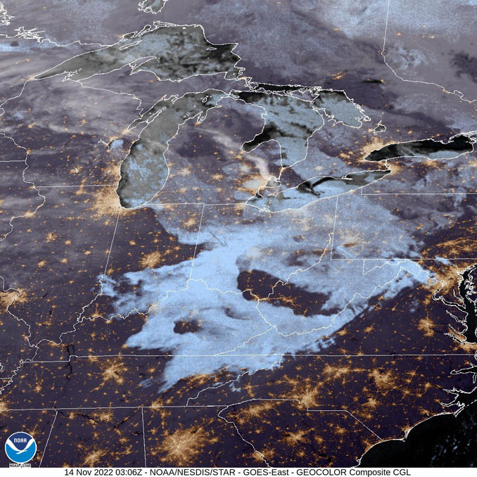
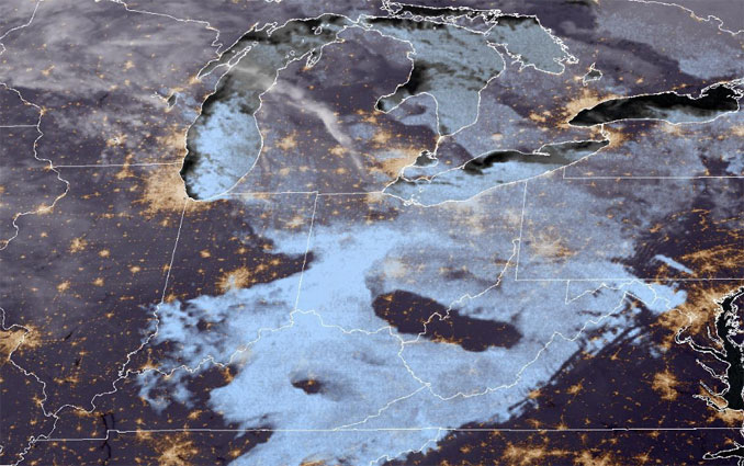
…Lake-effect snow downwind from the Great Lakes Sunday night into Monday…
…Light snow from the Southern High Plains to the Upper Midwest Monday evening into Tuesday…
…There are Winter Weather Advisories across parts of the Central Plains for Monday…
Upper-level energy over the Northeast will move into Southeastern Canada by Monday morning. As the energy departs, lake-effect snow downwind from Lakes Superior, Michigan, Huron, Erie, and Ontario ends late Sunday night. The energy will also produce light rain over parts of the Northeast, ending overnight Sunday. Light snow will also develop over parts of Northern New England, ending by Monday afternoon. The snow will result in reduced visibility and hazardous driving conditions.
Meanwhile, a second area of upper-level energy over the Southern California/Southwest will move northeastward to the Ohio Valley by Tuesday, inducing a front along the Central Gulf Coast into the Southeast. The energy will produce light snow over parts of the Great Basin, starting overnight Sunday, that will move into parts of the Central/Southern Rockies by Monday morning. On Monday, snow will develop over parts of the Central/Southern Plains, moving into the Middle Mississippi Valley overnight Monday and into parts of the Ohio Valley by Tuesday evening. The snow has prompted Winter Weather Advisories across parts of the Central Plains for Monday.
Moreover, as the energy moves out of the Rockies, moisture from the Western Gulf of Mexico will stream northward over the Southern Plains on Monday afternoon producing showers and thunderstorms over parts of the Southern Plains, moving into the Lower Mississippi Valley overnight Monday. On Tuesday morning, rain will develop over parts of the Ohio Valley, expanding into parts of the Mid-Atlantic by Tuesday evening. In addition, showers and thunderstorms will begin to develop over parts of the Southeast on Tuesday afternoon.
On Monday, a third area of upper-level energy will produce light snow over parts of the Upper Midwest. Furthermore, additional upper-level energy will move southward from West-Central Canada into the Northern High Plains on Monday afternoon. As a result, the energy produces light snow over parts of the Northern High/Northern Plains on Monday afternoon. On Monday, the light snow continues over parts of the Northern Plains/Upper Mississippi Valley that will expand into parts of the Great Lakes/Ohio Valley on Tuesday. The snow will result in reduced visibility and hazardous driving conditions.
Ziegenfelder/NWS
+++++++++++++++++
CONUS = Continental United States
SOURCE: NOAA/NWS Weather Prediction Center
AIR PRESSURE MAP SOURCE: Windy.com (air pressure)
Get updates from The Cardinal ALL NEWS FEEDS on Facebook. Just ‘LIKE’ the ‘Arlington Cardinal Page (become a fan of our page). The updates cover all posts and sub-category posts from The Cardinal — Arlingtoncardinal.com. You can also limit feeds to specific categories. See all of The Cardinal Facebook fan pages at Arlingtoncardinal.com/about/facebook …
Help fund The Cardinal Arlingtoncardinal.com/sponsor
Google Maps
The Maritimes — New Brunswick, Nova Scotia, and Prince Edward Island