
The NWS Chicago office has upgraded the heat advisory to an excessive heat warning for all but our northern tier of Illinois counties that border the Wisconsin state line. Record high temperatures are possible the next two days.
Excessive Heat Warning
URGENT – WEATHER MESSAGE
National Weather Service Chicago IL
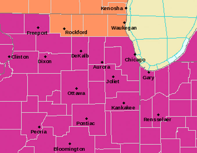
346 AM CDT Tue Jun 14 2022Ogle-De Kalb-Kane-DuPage-Northern Cook-Central Cook-Southern Cook … Including the cities of Rochelle, Oregon, Byron, DeKalb, Sycamore, Arlington Heights, Aurora, Elgin, Naperville, Wheaton, Downers Grove, Lombard, Carol Stream, Evanston, Des Plaines, Schaumburg, Palatine, Northbrook, Chicago, Cicero, Oak Lawn, Oak Park, La Grange, Calumet City, Oak Forest, Lemont, Orland Park, and Park Forest
346 AM CDT Tue Jun 14 2022
…EXCESSIVE HEAT WARNING IN EFFECT UNTIL 8 PM CDT WEDNESDAY…
* WHAT…Dangerously hot conditions with heat index values between 106 and 110.
* WHERE…Ogle, De Kalb, Kane, DuPage, Northern Cook, Central Cook and Southern Cook Counties.
* WHEN…Until 8 PM CDT Wednesday.
* IMPACTS…Extreme heat and humidity will significantly
increase the potential for heat related illnesses,
particularly for those working or participating in outdoor activities.* ADDITIONAL DETAILS…Humidity may be lower on Wednesday with high temperatures still in the mid to upper 90s.
PRECAUTIONARY/PREPAREDNESS ACTIONS…
Drink plenty of fluids, stay in an air-conditioned room, stay out of the sun, and check up on relatives and neighbors. Young children and pets should never be left unattended in vehicles under any circumstances.
Take extra precautions if you work or spend time outside. When possible reschedule strenuous activities to early morning or evening. Know the signs and symptoms of heat exhaustion and heat stroke. Wear lightweight and loose fitting clothing when possible. To reduce risk during outdoor work, the Occupational Safety and Health Administration recommends scheduling frequent rest breaks in shaded or air conditioned environments. Anyone
overcome by heat should be moved to a cool and shaded location.Heat stroke is an emergency! Call 9 1 1.
Early morning surface analysis around 3:30 a.m. indicated a warm front extending from just north of Sterling, Illinois to near Kankakee and Lafayette Indiana. After being suppressed by outflow from Monday evening’s severe storms, the warm front will surge northward this morning as an upper level ridge builds across the western Great Lakes region.
Southwesterly low level flow will spread a very warm and humid air with surface dew points in the low-mid 70s across the entire forecast area by late morning. Within this air mass surface temps are expected to top out in the mid-upper 90s this afternoon, with heat indices in the 105-110+ range. Areas south of the I-88 corridor in Illinois and all of northwest Indiana are most likely to see 110 degree heat indices, meeting warning criteria. Cook county`s warning criteria (formulated in the wake of the deadly 1995 heat wave) is three consecutive days of 100-105 degree peak heat indices.
Southern parts of Cook County (including Midway airport) broke 100 yesterday, and will again today and Wednesday. High temperatures will be similar Wednesday, except dew points will be slightly lower in the upper 60s and lower 70s. Heat indices are not expected to fall below the 75-80 degree range overnight Tuesday to Wednesday.
A cold front arcing south from low pressure over the Canadian prairies will approach the area from the northwest Wednesday afternoon, reaching from central Wisconsin into east-central Iowa late in the day. The current guidance suite indicates scattered strong to severe thunderstorms along/ahead of the cold front will remain largely north and west of the forecast area until evening. Although northwest counties around the Rockford area might see storms in the late afternoon hours.
Excessive Heat Warningalkjalkjsakl
Weather Radar in northeast Illinois was clear.
See also Arlingtoncardinal.com/clouds
NWStweet?
Run7DAYforecastPASTEHERE
SouthLakeMichiganDataPASTEHERE
june.chicagoweatherstation.com
Chicago Weather Forecast for your MAC/PC/TABLET includes surrounding suburbs.
^^ MOBILE? USE VOICE MIC ^^
facebook …
Please ‘LIKE’ the ‘Arlington Cardinal Page. See all of The Cardinal Facebook fan pages at Arlingtoncardinal.com/about/facebook …
Help fund The Cardinal Arlingtoncardinal.com/sponsor
20240105-1435future
