
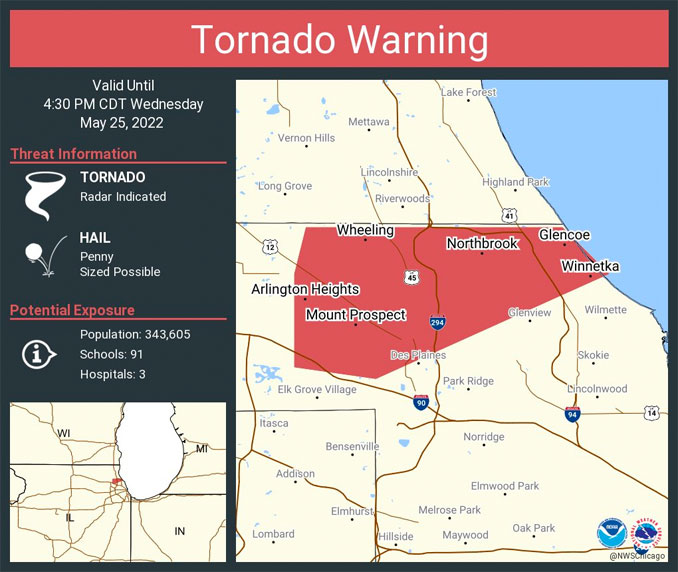
Tornado Warning
(Radar Indicated)
Arlington Heights and some other northwest and west suburbs were under a Tornado Warning activation because radar indicated rotation in a storm moving southwest to northeast in DuPage County and just northwest of O’Hare International Airport.
The storm associated with the rotating radar image did not actually threaten any areas of Arlington Heights except possibly the southeast area of Arlington Heights along Algonquin Road southeast of Arlington Heights Road and upward on the east side of Arlington Heights.
The storm also weakened as it edged northward over the northern edge of the warm front into cooler tornado-weakening conditions.
At around the time the storm was located over the southern tip of Arlington Heights at 4:05 p.m., winds reported at O’Hare International Airport at 3:51 p.m. were reported light and variable at 5 MPH with a gust to 18 MPH.
Below is the Tornado Warning status at 4:09 p.m. — just after the rotating storm passed the southeast tip of Arlington Heights at about 4:05 p.m. Tornado sirens were also activated in Arlington Heights, Prospect Heights and surrounding communities.
Tornado Warning
Severe Weather Statement
National Weather Service Chicago/Romeoville
409 PM CDT Wed May 25 2022
ILC031-252130-
/O.CON.KLOT.TO.W.0006.000000T0000Z-220525T2130Z/
Cook IL-
409 PM CDT Wed May 25 2022
…A TORNADO WARNING REMAINS IN EFFECT UNTIL 430 PM CDT FOR NORTH
CENTRAL COOK COUNTY…
At 408 PM CDT, a severe thunderstorm capable of producing a tornado
was located over Prospect Heights, or over Mount Prospect, moving
northeast at 35 mph.
HAZARD…Tornado.
SOURCE…Radar indicated rotation. This storm has a history of
producing funnel clouds!
IMPACT…Flying debris will be dangerous to those caught without
shelter. Mobile homes will be damaged or destroyed. Damage
to roofs, windows, and vehicles will occur. Tree damage is
likely.
This dangerous storm will be near…
Northbrook around 415 PM CDT.
Other locations in the path of this tornadic thunderstorm include
Deerfield, Winnetka, Glencoe and Northfield.
This includes… Oakton Community College.
Including the following interstates…
I-90 between mile markers 71 and 72.
I-94 between mile markers 26 and 33.
I-294 between mile markers 26 and 33.
PRECAUTIONARY/PREPAREDNESS ACTIONS…
TAKE COVER NOW! Move to a basement or an interior room on the lowest
floor of a sturdy building. Avoid windows. If you are outdoors, in a
mobile home, or in a vehicle, move to the closest substantial shelter
and protect yourself from flying debris.
&&
LAT…LON 4211 8772 4202 8792 4203 8799 4211 8799
4215 8798 4215 8776
TIME…MOT…LOC 2108Z 211DEG 31KT 4209 8792
TORNADO…RADAR INDICATED
MAX HAIL SIZE…<.75 IN
WEATHER RADAR
For LIVE Tornado Warnings for our area and United States, see Arlingtoncardinal.com/tornadowarning or Twitter.com/NWStornado
NWS Meteorologist Jacob DeFlitch caught an actual photo of the rotating storm cell northwest of O’Hare with sunshine and blue skies over O’Hare as drizzle and light rain was the observation in Arlington Heights. The photo is apparently showing the airfield in a view looking northwest.
Tornado warned storm from O’Hare @nwschicago pic.twitter.com/UvjZZ5SaZ8
— Jacob DeFlitch (@WxDeFlitch) May 25, 2022
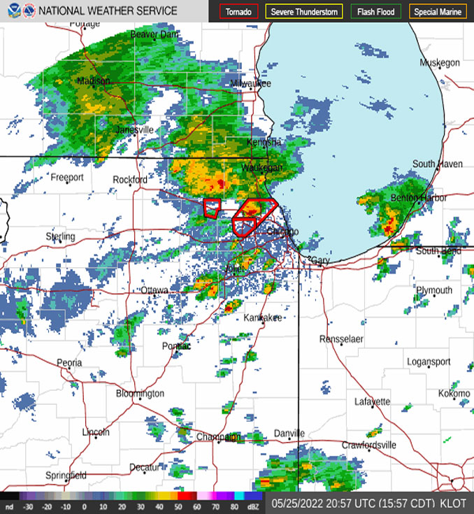
Here is the rotating storm path outline overlay with the radar image that indicated the far southeast tip of Arlington Heights could be hit by rotating storm cell. The red outline on the right was the path connected to the Arlington Heights Tornado Warning. The red outline on the left indicated the path connected to a Tornado Warning for Elgin, West Dundee and Carpentersville that was tweeted at 3:34 p.m.
^^ MOBILE? USE VOICE MIC ^^
facebook …
Please ‘LIKE’ the ‘Arlington Cardinal Page. See all of The Cardinal Facebook fan pages at Arlingtoncardinal.com/about/facebook …
Help fund The Cardinal Arlingtoncardinal.com/sponsor
20240105-1435future
THANKS FOR READING CARDINAL NEWS
A weak rotation can be visualized by upward spinning wisps of water vapor as a tornadic storm passed over Lake Cook Road and the Tri-Statw Tollway just before 4:30 pm. Follow all the latest updates on today’s storms at https://t.co/vhbRxCcLib pic.twitter.com/HTgoGVPshk
— Kris Habermehl (@KrisHabermehl) May 25, 2022
Rotation and a weak mesocyclone as the tornado warned cell passed Lake Cook Road just east of 294 in Deerfield. The storm that prompted the warning is moving out to Lake Michigan. pic.twitter.com/opCrTdbL06
— Kris Habermehl (@KrisHabermehl) May 25, 2022
