
A Severe Thunderstorm Watch in northern Illinois that excluded Lake, Cook, DuPage, and Will counties was expanded at 10:15 p.m. to include those counties. Thunderstorms are expected to arrive around 11:00 p.m. in Arlington Heights and leave the area by about 12:00 a.m. to 12:30 a.m.
The initial band of elevated convection across western Illinois has showed an uptick in intensity early this evening, likely at least partially in response to strengthening low level jet. The storms were in a strongly sheared environment with very steep lapse rates. By the time the storms reached Arlington Heights there was only a little lightning and thunder left in the storms. A lightning strike may have caused a fire in Des Plaines.
Early Saturday evening the NWS Office Chicago started to observe supercellular convection over Iowa grow upscale into a more linear structure. The line moved rapidly eastward this Saturday night, likely reaching our western county wide area roughly around 10:00 p.m. In northern Illinois, the front edge line of the storms reached from near Rockford to Peoria by about 10:00 p.m. A Severe Thunderstorm Warning was activated near Rockford about 9:20 p.m.
According to NWS Chicago, a narrow tongue of surface-based instability existed ahead of the line and guidance all suggested that instability will spread east into our county warning area in advance of the line. Given the ambient wind fields, it wouldn’t take much for a QLCS (Quasi-Linear Convective System or a strong line of thunderstorms that “is not quite straight”) to transport severe winds to the surface.
The big question tonight at this point is how quickly the line will weaken, as it was expected to be in the process of outrunning the narrow eastward spreading instability — and therefore weaken. In addition, the meager surface-based destabilization that was expected to take place this evening was expected to be accompanied by slowly strengthening convective inhibition.
NWS Chicago expected convection to weaken along with a weakening severe wind threat, but there was uncertainty when that weakening would take place. In the 10:00 o’clock hours it is possible that the convection is not weakening as fast as expected.
Weather Radar shows a line of strong thunderstorms from Wisconsin through north central Illinois into southern Illinois.
See also Arlingtoncardinal.com/clouds
Severe Thunderstorm Warning including Chicago IL, Aurora IL, Naperville IL until 11:45 PM CST. This storm will contain wind gusts to 70 MPH! pic.twitter.com/moG2TvQW2X
— NWS Severe Tstorm (@NWSSevereTstorm) March 6, 2022
We have expanded the Severe Thunderstorm Watch farther into the Chicago metro. While these storms as expected to weaken as they get further east, it's possible that they may still feature severe wind gusts by the time they reach the heart of the metro. https://t.co/rXh3CnHsQS
— NWS Chicago (@NWSChicago) March 6, 2022
Severe Thunderstorm Warning Severe Thunderstorm Warning
BULLETIN – IMMEDIATE BROADCAST REQUESTED Severe Thunderstorm Warning National Weather Service Chicago/Romeoville 1045 PM CST Sat Mar 5 2022
The National Weather Service in Chicago has issued a
* Severe Thunderstorm Warning for… Northern Kendall County in northeastern Illinois… Lake County in northeastern Illinois… Northwestern Will County in northeastern Illinois… Southern Kane County in northeastern Illinois… DuPage County in northeastern Illinois… Northern and Central Cook County in northeastern Illinois…
* Until 1145 PM CST.
* At 1044 PM CST, severe thunderstorms were located along a line extending from near Hebron to near Gilberts to near Sandwich, moving northeast at 60 mph.
HAZARD…70 mph wind gusts.
SOURCE…Radar indicated.
IMPACT…Expect considerable tree damage. Damage is likely to mobile homes, roofs, and outbuildings.
* Severe thunderstorms will be near… Elgin, Hoffman Estates, Carpentersville, Barrington Hills and East Dundee around 1050 PM CST. Wauconda, Barrington, Island Lake, Inverness, Lake Barrington, Fox River Grove, Port Barrington and Tower Lakes around 1055 PM CST. Aurora, Naperville, Palatine, Lake Zurich, Montgomery, Boulder Hill, Hawthorn Woods, Kildeer, Channel Lake and Forest Lake around 1100 PM CST.
PRECAUTIONARY/PREPAREDNESS ACTIONS…
For your protection move to an interior room on the lowest floor of a building.
&&
LAT…LON 4249 8780 4227 8783 4213 8774 4206 8767 4190 8761 4190 8760 4188 8762 4185 8761 4176 8755 4158 8860 4176 8860 4188 8827 4207 8827 4215 8824 4216 8820 4250 8820 TIME…MOT…LOC 0444Z 245DEG 53KT 4251 8846 4214 8836 4166 8859
THUNDERSTORM DAMAGE THREAT…CONSIDERABLE HAIL THREAT…RADAR INDICATED MAX HAIL SIZE…<.75 IN WIND THREAT...RADAR INDICATED MAX WIND GUST...70 MPH
Severe Thunderstorm Watch
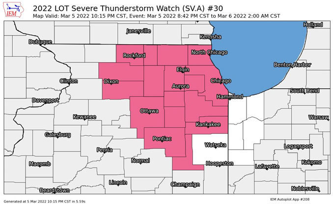
WATCH COUNTY NOTIFICATION FOR WATCH 30 NATIONAL WEATHER SERVICE CHICAGO IL 1015 PM CST SAT MAR 5 2022
ILC031-043-091-097-197-060800- /O.EXA.KLOT.SV.A.0030.000000T0000Z-220306T0800Z/
THE NATIONAL WEATHER SERVICE HAS EXTENDED SEVERE THUNDERSTORM WATCH 30 TO INCLUDE THE FOLLOWING AREAS UNTIL 2 AM CST SUNDAY
IN ILLINOIS THIS WATCH INCLUDES 5 COUNTIES
IN NORTHEAST ILLINOIS
COOK DUPAGE KANKAKEE LAKE IL WILL
THIS INCLUDES THE CITIES OF BOLINGBROOK, BOURBONNAIS, BUFFALO GROVE, CAROL STREAM, CHICAGO, DOWNERS GROVE, EVANSTON, GURNEE, JOLIET, KANKAKEE, LEMONT, LOMBARD, MUNDELEIN, NAPERVILLE, OAK LAWN, ORLAND PARK, PARK FOREST, SCHAUMBURG, WAUKEGAN, WHEATON, AND WILMINGTON.
A Wind Advisory remains in effect with wind gusts, even without the presence of a thunderstorm, expected to remain in the 40+ MPH range all night. Peak non-thunderstorm wind gusts are expected to peak at around 47 MPH from 3 AM to 4 AM.
Wind Advisory
URGENT – WEATHER MESSAGE National Weather Service Chicago IL 838 PM CST Sat Mar 5 2022
Winnebago-Boone-McHenry-Lake IL-Ogle-Lee-De Kalb-Kane-DuPage- La Salle-Kendall-Grundy-Kankakee-Livingston-Iroquois-Ford- Northern Cook-Central Cook-Southern Cook-Northern Will- Southern Will-Eastern Will-Lake IN-Porter-Newton-Jasper-Benton- Including the cities of Rockford, Belvidere, Crystal Lake, Algonquin, McHenry, Woodstock, Waukegan, Buffalo Grove, Mundelein, Gurnee, Rochelle, Oregon, Byron, Dixon, DeKalb, Sycamore, Aurora, Elgin, Naperville, Wheaton, Downers Grove, Lombard, Carol Stream, Ottawa, Streator, La Salle, Mendota, Marseilles, Oswego, Yorkville, Plano, Morris, Coal City, Minooka, Kankakee, Bourbonnais, Bradley, Pontiac, Dwight, Fairbury, Watseka, Gilman, Paxton, Gibson City, Evanston, Des Plaines, Schaumburg, Palatine, Northbrook, Chicago, Cicero, Oak Lawn, Oak Park, La Grange, Calumet City, Oak Forest, Lemont, Orland Park, Park Forest, Joliet, Bolingbrook, Plainfield, Mokena, Channahon, Manhattan, Wilmington, Crete, Peotone, Beecher, Gary, Hammond, Merrillville, Portage, Valparaiso, Chesterton, Roselawn, Kentland, Morocco, Rensselaer, DeMotte, Fowler, and Oxford 838 PM CST Sat Mar 5 2022 /938 PM EST Sat Mar 5 2022/
…WIND ADVISORY REMAINS IN EFFECT UNTIL 9 AM CST SUNDAY…
* WHAT…South winds 20 to 30 mph with gusts to 45 mph this evening and west gusting to around 50 mph overnight expected.
* WHERE…Portions of northwest Indiana and central, east central, north central and northeast Illinois.
* WHEN…Until 9 AM CST Sunday.
* IMPACTS…Gusty winds could blow around unsecured objects. Tree limbs could be blown down and a few power outages may result.
PRECAUTIONARY/PREPAREDNESS ACTIONS…
Use extra caution when driving, especially if operating a high profile vehicle. Secure outdoor objects.
O’HARE FORECAST …
Tonight: Showers and thunderstorms, mainly before midnight. Low around 36. Windy, with a south southwest wind 25 to 30 mph, with gusts as high as 45 mph. Chance of precipitation is 80%. New rainfall amounts of less than a tenth of an inch, except higher amounts possible in thunderstorms.
Sunday: Partly sunny, with a high near 48. Windy, with a west wind 20 to 30 mph decreasing to 10 to 20 mph in the afternoon. Winds could gust as high as 45 mph.
Sunday Night: Rain before 1am, then rain and snow between 1am and 3am, then snow after 3am. Low around 32. West northwest wind 5 to 10 mph becoming north northeast after midnight. Winds could gust as high as 15 mph. Chance of precipitation is 90%. New snow accumulation of less than one inch possible.
Monday: Snow likely before noon. Cloudy, with a high near 37. Northwest wind 10 to 15 mph, with gusts as high as 20 mph. Chance of precipitation is 60%. New snow accumulation of less than one inch possible.
Monday Night: Partly cloudy, with a low around 24. West northwest wind 5 to 10 mph, with gusts as high as 15 mph.
Tuesday: Sunny, with a high near 42.
Tuesday Night: Mostly clear, with a low around 28.
Wednesday: Sunny, with a high near 43.
Wednesday Night: Mostly cloudy, with a low around 30.
Thursday: A slight chance of rain after noon. Partly sunny, with a high near 46.
Thursday Night: A chance of rain and snow. Mostly cloudy, with a low around 26.
Friday: A chance of snow. Mostly cloudy, with a high near 34.
Friday Night: A chance of snow. Mostly cloudy, with a low around 15.
Saturday: Mostly sunny, with a high near 28.
SouthLakeMichiganDataPASTEHERE
march.chicagoweatherstation.com
Chicago Weather Forecast for your MAC/PC/TABLET includes surrounding suburbs.
^^ MOBILE? USE VOICE MIC ^^
facebook …
Please ‘LIKE’ the ‘Arlington Cardinal Page. See all of The Cardinal Facebook fan pages at Arlingtoncardinal.com/about/facebook …
Help fund The Cardinal Arlingtoncardinal.com/sponsor
20240105-1435future
