
A winter storm is forecast to strike Chicagoland Tuesday night February 1, 2022 through Wednesday, with accumulating snow of a lesser disturbance and also light Lake Effect Snow (LES) likely to linger into Thursday.
Overnight DuPage and Kendall counties were added to the Winter Storm Warning, as snow amounts in excess of 6 inches looks probable at these locations as well, especially in southern sections of these counties. Arlington Heights was upgraded to a Winter Weather Advisory overnight.
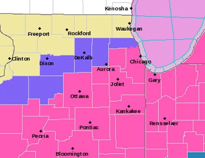
O”Hare International Airport is in the Winter Storm Warning category, while just north of the airport in Des Plaines, southern Mount Prospect, and southern Arlington Heights is in the Winter Weather Advisory category.
Confidence continues to increase with very heavy snowfall amounts materializing, with amounts up to and even exceeding a foot likely in southern parts of Chicagoland through early Wednesday evening. Unfortunately, however, uncertainties continue to be above average with forecast snowfall amounts across far northern IL, especially along and north of I-88, where a sharp northwest to southeast gradient in snow amounts is likely to reside.
Overnight on the ECMWF weather model Arlington Heights snowfall accumulation wavered between 4.7 inches and 5.3 inches.
At 7:15 AM the NWS Chicago office forecast the following accumulation outlooks showing the gradient from south to north …
O’Hare International Airport
5.6″ Tuesday 6 PM to Thursday 11 AMLake Briarwood in south Arlington Heights
4.6″ Tuesday 6 PM to Thursday 11 AMDowntown Arlington Heights
3.8″ Tuesday 6 PM to Thursday 11 AMLake Terramere in north Arlington Heights
2.9″ Tuesday 6 PM to Thursday 11 AM
Global Weather Models on Arlingtoncardinal.com/snow
Breezy southerly winds developed across the area overnight in the warm sector of a strong area low pressure shifting eastward into far southwestern Ontario. Temperatures have responded by steadily warming into the lower 30s through the night, and this warm start to the day will help push temperatures into the low- to mid-40s for highs early Tuesday afternoon in advance of an approaching cold front. The cold front will move over the area early this evening. Precipitation, likely initially in the form of rain, will develop in the vicinity of the front this afternoon over parts of northeastern Illinois into northwestern Indiana. The rain will then change to snow from northwest to southeast through the evening as colder air filters into the area.
The complicating factor to the snow forecast tonight is that a drier low level airmass will be trying to undercut the better moisture shifting in from the south tonight. This is likely to prohibit snow from reaching the ground (due to sublimation) across parts of far northern/northwestern Illinois where the drier lower level airmass looks to become the most pronounced. A sharp northwest to southeast gradient in snowfall amounts is thus likely to set up somewhere across far northern Illinois into Wednesday morning.
Where it does snow tonight into Wednesday (likely across most of the warned and advisory areas), the the rates are likely to be moderate to heavy at times (1″+ per hour). The period of highest rates is expected to be after midnight tonight through early Wednesday afternoon. During this period, forecast guidance continues to develop a strong and rather persistent low-to-mid level frontogenetic circulation over the area in association with a strengthening baroclinic zone and beneath the favorable entrance (exit) region of an Upper Great Lakes (southern and central Plains) jet streak. Together, this should produce deep and strong forced ascent through the dendritic growth zone, and through an elevated layer of rather steep lapse rates (in excess of 6.5C per KM). Moisture should also become plentiful, especially in the waring area, where a feed of deeper Gulf Moisture is expected. Significant snow accumulations up to, and even a bit above a foot are forecast through early Wednesday evening, especially across southern sections of the area. This will most certainly create dangerous travel conditions across the area late tonight through Wednesday.
NOTE: The second system is less likely to have much punch (including accumulation) as forecast time approaches storm time.
Additional snow accumulations continue to look probable Wednesday night into Thursday in association with the next wave shifting out of the southwestern Continental United States. However, the main area with a threat of at least a few additional inches of snow is expected to be in the southern/southeastern area (east central Illinois and into parts of northwestern Indiana). Farther to the north, lake effect/enhanced snow showers may result in some additional accumulations across parts of northeastern Illinois on Thursday. However, the lake effect parameters do not look overly impressive, so any additional snow amounts look to be on the light side, and likely not of warning caliber impacts. Any lingering snow should end across the area late Thursday, according to the NWS Chicago office.
Weather Radar in northeast Illinois was clear.
See also Arlingtoncardinal.com/clouds
Here is a look at the timing of the highest snow rates, which could exceed an inch per hour at times, tonight into Wednesday. Note the snow chances will continue for some areas into Thursday. #ilwx #inwx pic.twitter.com/AWbyLxjm28
— NWS Chicago (@NWSChicago) February 1, 2022
5:00 AM 2/1/2022: A winter storm will impact northeastern Illinois and northwestern Indiana tonight through Thursday. The majority of snow will fall tonight through Wednesday with widespread travel disruptions. A sharp gradient in snow will occur in northwestern IL. #ilwx #inwx pic.twitter.com/OST0jqMluE
— NWS Chicago (@NWSChicago) February 1, 2022
ROUND 1 SNOW
Expectation of round one of this week’s snow. Confidence is fairly high on this event! pic.twitter.com/8EumsreFT1
— NWS Chicago (@NWSChicago) January 31, 2022
ROUND 2 SNOW
The trend has been for round 2 to pass through central IL and IN, sideswiping our area. Additional snow accumulations are most likely south of a line from Pontiac, IL to Valparaiso, IN. Additional shifts south are entirely possible. #ilwx #inwx pic.twitter.com/GIpKMxlP60
— NWS Chicago (@NWSChicago) February 1, 2022
Winter Weather Advisory URGENT – WINTER WEATHER MESSAGE National Weather Service Chicago IL 238 AM CST Tue Feb 1 2022
ILZ010>012-103-011645- /O.NEW.KLOT.WW.Y.0007.220202T0200Z-220203T0000Z/ Lee-De Kalb-Kane-Northern Cook- Including the cities of Dixon, DeKalb, Sycamore, Aurora, Elgin, Evanston, Des Plaines, Schaumburg, Palatine, and Northbrook 238 AM CST Tue Feb 1 2022
…WINTER WEATHER ADVISORY IN EFFECT FROM 8 PM THIS EVENING TO 6 PM CST WEDNESDAY…
* WHAT…Snow and slippery travel expected. Total snow accumulations of 1 to 5 inches are expected. A sharp snowfall gradient is expected across the Chicago metropolitan area and the Illinois River Valley, with the highest amounts farther south.
* WHERE…Lee, De Kalb, Kane and Northern Cook Counties.
* WHEN…From 8 PM this evening to 6 PM CST Wednesday.
* IMPACTS…Plan on slippery road conditions. The hazardous conditions will impact the morning and evening commutes on Wednesday.
PRECAUTIONARY/PREPAREDNESS ACTIONS…
Slow down and use caution while traveling.
The latest road conditions for Illinois can be obtained on the internet at www.gettingaroundillinois.com.
Winter Storm Warning URGENT – WINTER WEATHER MESSAGE National Weather Service Chicago IL 238 AM CST Tue Feb 1 2022
ILZ019-021-104>108-011645- /O.UPG.KLOT.WS.A.0004.220202T0200Z-220204T0000Z/ /O.EXB.KLOT.WS.W.0003.220202T0200Z-220203T0000Z/ La Salle-Grundy-Central Cook-Southern Cook-Northern Will- Southern Will-Eastern Will- Including the cities of Ottawa, Streator, La Salle, Mendota, Marseilles, Morris, Coal City, Minooka, Chicago, Cicero, Oak Lawn, Oak Park, La Grange, Calumet City, Oak Forest, Lemont, Orland Park, Park Forest, Joliet, Bolingbrook, Plainfield, Mokena, Channahon, Manhattan, Wilmington, Crete, Peotone, and Beecher 238 AM CST Tue Feb 1 2022
…WINTER STORM WARNING IN EFFECT FROM 8 PM THIS EVENING TO 6 PM CST WEDNESDAY…
* WHAT…Heavy snow and dangerous travel expected. Total snow accumulations of 5 to 11 inches are expected. A sharp snowfall gradient is expected across the Chicago metropolitan area and Illinois River Valley, with the highest amounts farther south. The highest snowfall rates, of up to an inch per hour, will be after midnight tonight through early Wednesday afternoon.
* WHERE…Portions of north central and northeast Illinois.
* WHEN…From 8 PM this evening to 6 PM CST Wednesday.
* IMPACTS…Travel will become very difficult. The hazardous conditions will impact the morning and evening commutes on Wednesday.
* ADDITIONAL DETAILS…Additional snow may continue beyond the current end time of the Winter Storm Warning into Thursday.
PRECAUTIONARY/PREPAREDNESS ACTIONS…
If you must travel, keep an extra flashlight, food, and water in your vehicle in case of an emergency.
The latest road conditions for Illinois can be obtained on the internet at www.gettingaroundillinois.com.
O’HARE FORECAST …
Today: Rain likely, mainly after 4pm. Mostly cloudy, with a high near 43. South wind 10 to 15 mph, with gusts as high as 30 mph. Chance of precipitation is 70%. New precipitation amounts of less than a tenth of an inch possible.
Tonight: Rain likely before 7pm, then rain and snow likely between 7pm and 8pm, then snow after 8pm. Low around 18. West wind 10 to 15 mph becoming north after midnight. Winds could gust as high as 20 mph. Chance of precipitation is 90%. New snow accumulation of around an inch possible.
Wednesday: Snow. High near 24. North wind around 15 mph, with gusts as high as 25 mph. Chance of precipitation is 100%. New snow accumulation of 2 to 4 inches possible.
Wednesday Night: Snow likely. Cloudy, with a low around 19. North wind around 15 mph, with gusts as high as 25 mph. Chance of precipitation is 70%. New snow accumulation of less than one inch possible.
Thursday: Snow likely, mainly before 1pm. Cloudy, with a high near 24. Blustery, with a north northeast wind 15 to 20 mph, with gusts as high as 25 mph. Chance of precipitation is 70%.
Thursday Night: A 40 percent chance of snow before 7pm. Mostly cloudy, with a low around 12.
Friday: Partly sunny, with a high near 21.
Friday Night: Partly cloudy, with a low around 7.
Saturday: Mostly sunny, with a high near 21.
Saturday Night: Partly cloudy, with a low around 15.
Sunday: Partly sunny, with a high near 26.
Sunday Night: Mostly cloudy, with a low around 15.
Monday: Partly sunny, with a high near 23.
LAKE TEMPS …
SOUTHERN LAKE MICHIGAN WATER TEMPERATURES
NATIONAL WEATHER SERVICE CHICAGO/ROMEOVILLE IL
902 AM CST Mon Jan 31 2022
LAKE MICHIGAN WATER TEMPERATURES…
CHICAGO SHORE………33.
CHICAGO CRIB……….33.
MICHIGAN CITY……….33.
&&
M IS FOR MISSING DATA THAT IS NORMALLY AVAILABLE.
THE MICHIGAN CITY WATER TEMPERATURE SENSOR IS LOCATED AT A WATER
INTAKE ONE MILE OFFSHORE AND 60 FEET BELOW WATER SURFACE. IT IS READ EVERY DAY OF THE YEAR.
february.chicagoweatherstation.com
Chicago Weather Forecast for your MAC/PC/TABLET includes surrounding suburbs.
^^ MOBILE? USE VOICE MIC ^^
facebook …
Please ‘LIKE’ the ‘Arlington Cardinal Page. See all of The Cardinal Facebook fan pages at Arlingtoncardinal.com/about/facebook …
Help fund The Cardinal Arlingtoncardinal.com/sponsor
20240105-1435future
