
Air temperature has been rising since midnight Saturday/Sunday, and temperatures remain on the increase as warm advection begins to ramp up with southerly winds already gusting into the 20-30 mph range. Expect a continued gradual increase in surface wind speeds and gusts through the early morning hours with high confidence in south to southwest gusts as high as 45-50 mph for areas north of I-80 from mid morning through early afternoon. This will make travel hazardous for high profile vehicles and blow around light unsecured objects. Wind chill Sunday is forecast to reach no higher than 38°F.
Here are the important features of the weather for Sunday and Sunday night …
Strong southwest winds gusting to 45+ mph today
Potential for blowing/drifting snow before snow melt commences
Warming temps in the 40s today – possibly lower 50s in snow-free areas
Some fog possible overnight
With the increase in wind speeds brings a concern for another round of blowing and drifting snow in open and rural areas Sunday morning until surface temperatures begin to rise above freezing late this morning. Once snow melt commences this should reduce the coverage of additional blowing snow. For those traveling along east-west oriented roadways this morning plan for highly varying road conditions with patchy slick spots in open areas possible.
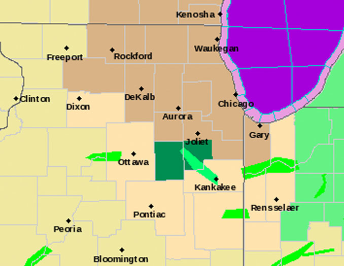
The axis of the deeper snow pack is roughly along a line from Pontiac, IL northeast toward Valparaiso, IN. This will act against the warming somewhat (as well as help limit some of the higher wind gusts), with high temperatures only around 40 degrees. Elsewhere to the north and west temperatures should warm into the mid to upper 40s, with lower 50s even possible in snow free areas out toward Rockford. A much welcomed warm up compared to yesterday, albeit much windier!
The strong wind gusts will persist into early afternoon before the low-level jet overhead begins to shift to our east and the surface pressure gradient relaxes. No changes were made to the Wind Advisory which goes from 9am-3pm CST. It is possible sporadic gusts over 40 mph will persist through 4-6pm but the more widespread higher gusts will be on a downward trend by then.
Tonight the surface trough axis/cold front stalls over the area with winds notably lighter overnight. The combination of light winds and higher dewpoints will bring a chance for fog development. For now have maintained just a patchy fog mention. In addition, there is a non-zero chance for some light drizzle, possibly even light freezing drizzle early Monday morning but the signal is still rather weak so have opted to maintain a dry forecast for now.
For Monday, with the surface front stalled across the area, a notable temperature gradient is anticipated with highs in only in the mid 30s to around 40 generally north of I-88 and 40s to 50s south. Temperatures will also be cooler across northeast Illinois near the lakeshore with onshore flow off a chilled lake helping keep things cooler. There is a chance of drizzle late Monday afternoon as our next weather system is approaching the area, although isentropic ascent and moisture looks better heading into the evening and overnight hours for more widespread precipitation.
Weather Radar in northeast Illinois was clear.
See also Arlingtoncardinal.com/clouds
After a windy day today, a weak front will move over the area Mon into Tue and result in a large temperature difference from north to south. As showers and even some t-storms spread over the area Mon night, some rain near the WI state line may fall as freezing rain. #ILwx #INwx pic.twitter.com/mDYQpkHSPb
— NWS Chicago (@NWSChicago) February 20, 2022
Gusty SSW winds expected areawide today. The strongest winds (gusts to 45 mph) expected mid morning through mid afternoon, generally along & N of I-80. Where a deeper snow pack exists, blowing/drifting snow is possible through the AM before temps rise above freezing. #ILwx #INwx pic.twitter.com/2YwAprBsby
— NWS Chicago (@NWSChicago) February 20, 2022
Wind Advisory URGENT – WEATHER MESSAGE National Weather Service Chicago IL 347 AM CST Sun Feb 20 2022
Winnebago-Boone-McHenry-Lake IL-Ogle-De Kalb-Kane-DuPage-Kendall- Northern Cook-Central Cook-Southern Cook-Northern Will- Southern Will-Eastern Will-Lake IN- Including the cities of Rockford, Belvidere, Crystal Lake, Algonquin, McHenry, Woodstock, Waukegan, Buffalo Grove, Mundelein, Gurnee, Rochelle, Oregon, Byron, DeKalb, Sycamore, Aurora, Elgin, Naperville, Wheaton, Downers Grove, Lombard, Carol Stream, Oswego, Yorkville, Plano, Evanston, Des Plaines, Schaumburg, Palatine, Northbrook, Chicago, Cicero, Oak Lawn, Oak Park, La Grange, Calumet City, Oak Forest, Lemont, Orland Park, Park Forest, Joliet, Bolingbrook, Plainfield, Mokena, Channahon, Manhattan, Wilmington, Crete, Peotone, Beecher, Gary, Hammond, and Merrillville 347 AM CST Sun Feb 20 2022
…WIND ADVISORY REMAINS IN EFFECT FROM 9 AM THIS MORNING TO 3 PM CST THIS AFTERNOON…
* WHAT…Southwest winds 25 to 30 mph with gusts up to 45 mph expected.
* WHERE…Portions of north central and northeast Illinois and Lake County Indiana.
* WHEN…From 9 AM this morning to 3 PM CST this afternoon.
* IMPACTS…Gusty winds could blow around unsecured objects. Tree limbs could be blown down and a few power outages may result. Travel will be difficult for high profile vehicles.
* ADDITIONAL DETAILS…Where a snowpack exists, the strong winds may cause period of low visibility and drifting across east-west roadways in open and rural areas this morning before temperature rise well above freezing by the afternoon.
PRECAUTIONARY/PREPAREDNESS ACTIONS…
Use extra caution when driving, especially if operating a high profile vehicle. Secure outdoor objects.
O’HARE FORECAST …
Today: Patchy blowing snow before noon. Sunny, with a high near 46. Windy, with a south southwest wind 20 to 30 mph, with gusts as high as 45 mph.
Tonight: Patchy fog after midnight. Otherwise, mostly cloudy, with a low around 33. Southwest wind 5 to 15 mph becoming north northeast after midnight. Winds could gust as high as 25 mph.
Washington’s Birthday: Patchy fog before 9am. Otherwise, mostly cloudy, with a high near 42. East wind 5 to 10 mph, with gusts as high as 20 mph.
Monday Night: Rain, with thunderstorms also possible after midnight. Areas of fog. Low around 36. East wind 5 to 10 mph. Chance of precipitation is 100%.
Tuesday: Rain and possibly a thunderstorm before noon, then a chance of rain. High near 41. North northeast wind 10 to 15 mph becoming west northwest in the afternoon. Winds could gust as high as 20 mph. Chance of precipitation is 80%.
Tuesday Night: Mostly cloudy, with a low around 16. Blustery.
Wednesday: Partly sunny, with a high near 26.
Wednesday Night: A slight chance of snow after midnight. Mostly cloudy, with a low around 20.
Thursday: Snow likely, mainly after noon. Cloudy, with a high near 28.
Thursday Night: Snow likely, mainly before midnight. Cloudy, with a low around 20.
Friday: Mostly cloudy, with a high near 26.
Friday Night: Partly cloudy, with a low around 12.
Saturday: Sunny, with a high near 29.
LAKE TEMPS …
SOUTHERN LAKE MICHIGAN WATER TEMPERATURES
NATIONAL WEATHER SERVICE CHICAGO/ROMEOVILLE IL
900 AM CST Sat Feb 19 2022
LAKE MICHIGAN WATER TEMPERATURES…
CHICAGO SHORE………32.
CHICAGO CRIB……….32.
MICHIGAN CITY……….33.
&&
M IS FOR MISSING DATA THAT IS NORMALLY AVAILABLE.
THE MICHIGAN CITY WATER TEMPERATURE SENSOR IS LOCATED AT A WATER
INTAKE ONE MILE OFFSHORE AND 60 FEET BELOW WATER SURFACE. IT IS READ EVERY DAY OF THE YEAR.
february.chicagoweatherstation.com
Chicago Weather Forecast for your MAC/PC/TABLET includes surrounding suburbs.
^^ MOBILE? USE VOICE MIC ^^
facebook …
Please ‘LIKE’ the ‘Arlington Cardinal Page. See all of The Cardinal Facebook fan pages at Arlingtoncardinal.com/about/facebook …
Help fund The Cardinal Arlingtoncardinal.com/sponsor
20240105-1435future
