
Snowfall began late because a very dry low-level airmass undercutting the better moisture and forced ascent aloft. In other words, snow wasn’t making it to the ground — subliming in dry air. The effect of the dry airmass was a forecast factor all along that was indicated could diminish snowfall accumulation totals north.
Chicago NWS O’Hare reported snow as early as 9:51 p.m. Tuesday, but snow accumulation in Arlington Heights didn’t begin until around 3 to 4 AM. Only 0.25 inch of snow accumulated at 5:00 a.m. and 0.5 inch accumulated at 6:00 a.m. in central Arlington Heights (snowfall rate 0.25″ per hour). Then 1.5 inch was measured at 7:00 a.m. (snowfall rate 1.00″ per hour for 6 to 7 a.m.).
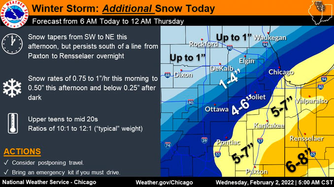
While it is likely that some snow will reach the surface across areas north of I-88 for a period this morning, snow amounts are expected to remain very light, according to the NWS Office Chicago. A very sharp and significant snowfall gradient along and just north of a line running from near Mendota, east-northeastward to near OHARE is expected. South of this line, NWS Chicago expects periods of moderate to at times heavy snow through the morning. Snow rates will then begin to ease from northwest to southeast into this afternoon. In the first phase snow expect snowfall amounts to total out near, or even excess of a foot, especially over parts of the southern Chicago suburbs. Amounts will quickly taper off north and northwest of the city, with amounts likely to remain under an inch in McHenry County and points west into the Rockford area.
At 5:45 AM the NWS Chicago office forecast the following accumulation outlooks showing the gradient from south to north …
O’Hare International Airport
7.4″ Wednesday 5 AM to Thursday 11 PMLake Briarwood in south Arlington Heights
5.4″ Wednesday 5 AM to Thursday 11 PMDowntown Arlington Heights
4.2″ Wednesday 5 AM to Thursday 11 PMLake Arlington Near North Arlington Heights
4.9″ Wednesday 5 AM to Thursday 11 PM
(higher likely Lake Effect Snow)Lake Terramere in north Arlington Heights
2.6″ Wednesday 5 AM to Thursday 11 PM
Baroclinic Zone
Temperature gradient in constant air pressure.
The snow is likely to become very light, or even stop for a period this evening as the lower-level baroclinic zone sags to the south. However, another wave coming out of the southwest CONUS is likely to result in a northward redevelopment of the snow into at least my southern counties (south of I-80) overnight tonight into Thursday. Additional snow accumulations are expected to be well south of I-80 with this second wave of snow, but these amounts do not look overly heavy. The current forecast is advertising about 2 to 4 additional inches across my far southern counties into central IL and IN. If forecast trends continue to support lighter snow amounts on Thursday, as mentioned above, the Winter Storm Warning may be able to be converted to Winter Weather Advisory.
Farther north, snow will also be possible Wednesday night into Thursday, especially across northeastern Illinois, where some accumulating lake effect snow (LES) is possible. Lake effect thermodynamic parameters do not look overly impressive for significant lake effect snow amounts into Thursday. In fact, lake induced equilibrium levels only look to be around 5,000 feet. However, given this lake induced unstable layer should reach into the dendritic growth zone, some better quality snow could develop in any more organized bands, thus potentially supporting more accumulating snow in parts of the Chicago metro area. These lake effect snow showers could linger into early Thursday evening, but the snow will be ending across the entire area by late Thursday.
Weather Radar shows snow moving southwest to northeast over all of northern Illinois and southeast Wisconsin. Radar indicates snowfall intensity is increasing from 4:00 a.m. to 6:00 a.m. Wednesday. The heaviest snow rates will continue generally along and southeast of I-55, according to NWS Chicago.
See also Arlingtoncardinal.com/clouds
Here's a look at *additional* snow totals from 6 AM through midnight tonight. Much of what is shown on the map will fall before noon. The highest accumulations will be along and southeast of I-55. #ilwx #inwx pic.twitter.com/oWZkbbLRua
— NWS Chicago (@NWSChicago) February 2, 2022
5:00 AM CST Update: Snow will continue this morning and taper this afternoon, followed by lake effect snow tonight and Thursday in northeastern Illinois. the highest additional accumulations will be along/SE of I-55 today and around the Chicago area tomorrow. #ilwx #inwx pic.twitter.com/gPJQkQJxiW
— NWS Chicago (@NWSChicago) February 2, 2022
"Round 2" looks to largely miss our area to the south. However, additional accumulations of 2-4" are possible south of a line from Paxton to Rensselaer. Lake effect snow will also deliver localized accumulations to NE Illinois. Most areas won't see much snow tomorrow. #ilwx #inwx pic.twitter.com/mpYS6FGFn7
— NWS Chicago (@NWSChicago) February 2, 2022
Steady snowfall ❄️ in Champaign #Illinois @NWSLincolnIL @ChambanaWX @skydrama pic.twitter.com/LUcy2HBIHB
— Illinois Newsroom (@ILNewsroom) February 2, 2022
Good morning at 6am from a snowy @ILPublicMedia on the campus of @UofILSystem @UofIllinois #WinterStorm pic.twitter.com/yvZpuJfPcn
— Illinois Newsroom (@ILNewsroom) February 2, 2022
Winter Weather Advisory
URGENT – WINTER WEATHER MESSAGE
National Weather Service Chicago IL
433 AM CST Wed Feb 2 2022
ILZ010>012-103-021845-
/O.CON.KLOT.WW.Y.0007.000000T0000Z-220203T0000Z/
Lee-De Kalb-Kane-Northern Cook-
Including the cities of Dixon, DeKalb, Sycamore, Aurora, Elgin,
Evanston, Des Plaines, Schaumburg, Palatine, and Northbrook
433 AM CST Wed Feb 2 2022
…WINTER WEATHER ADVISORY REMAINS IN EFFECT UNTIL 6 PM CST THIS
EVENING…
* WHAT…Snow and slippery travel expected. Total snow
accumulations of 2 to 5 inches. A sharp snowfall gradient is
expected in the advisory area, with the highest totals across
the southern portions of Lee, De Kalb, Kane, and Northern Cook
counties.
* WHERE…Lee, De Kalb, Kane and Northern Cook Counties.
* WHEN…Until 6 PM CST This Evening.
* IMPACTS…Plan on slippery road conditions. The hazardous
conditions will impact the morning and possibly the evening
commutes today.
PRECAUTIONARY/PREPAREDNESS ACTIONS…
Slow down and use caution while traveling.
The latest road conditions for Illinois can be obtained on the internet at www.gettingaroundillinois.com.
Winter Storm Warning URGENT – WINTER WEATHER MESSAGE National Weather Service Chicago IL 433 AM CST Wed Feb 2 2022
ILZ013-019>021-104>108-021845- /O.CON.KLOT.WS.W.0003.000000T0000Z-220203T0000Z/ DuPage-La Salle-Kendall-Grundy-Central Cook-Southern Cook- Northern Will-Southern Will-Eastern Will- Including the cities of Naperville, Wheaton, Downers Grove, Lombard, Carol Stream, Ottawa, Streator, La Salle, Mendota, Marseilles, Oswego, Yorkville, Plano, Morris, Coal City, Minooka, Chicago, Cicero, Oak Lawn, Oak Park, La Grange, Calumet City, Oak Forest, Lemont, Orland Park, Park Forest, Joliet, Bolingbrook, Plainfield, Mokena, Channahon, Manhattan, Wilmington, Crete, Peotone, and Beecher 433 AM CST Wed Feb 2 2022
…WINTER STORM WARNING REMAINS IN EFFECT UNTIL 6 PM CST THIS EVENING…
* WHAT…Heavy snowfall rates and dangerous travel expected. Total snow accumulations of 5 to 12 inches. A sharp snowfall gradient is expected across the Chicago metropolitan area and Illinois River Valley, with the highest amounts south. The highest snowfall rates, in excess of one inch per hour, will occur through this morning.
* WHERE…Portions of north central and northeast Illinois.
* WHEN…Until 6 PM CST This Evening.
* IMPACTS…Travel will be very difficult. The hazardous conditions will impact the morning and possibly evening commutes today.
PRECAUTIONARY/PREPAREDNESS ACTIONS…
If you must travel, keep an extra flashlight, food, and water in your vehicle in case of an emergency.
The latest road conditions for Illinois can be obtained on the internet at www.gettingaroundillinois.com.
O’HARE FORECAST …
Overnight: Snow. Low around 20. North wind around 15 mph, with gusts as high as 20 mph. Chance of precipitation is 100%. Total nighttime snow accumulation of 2 to 4 inches possible.
Wednesday: Snow, mainly before 4pm. High near 22. North wind around 15 mph, with gusts as high as 30 mph. Chance of precipitation is 100%. New snow accumulation of 2 to 4 inches possible.
Wednesday Night: Snow likely, mainly after 1am. Cloudy, with a low around 18. North wind around 15 mph, with gusts as high as 30 mph. Chance of precipitation is 70%. New snow accumulation of 1 to 3 inches possible.
Thursday: Snow likely, mainly before noon. Cloudy, with a high near 23. Blustery, with a north wind 15 to 20 mph, with gusts as high as 30 mph. Chance of precipitation is 70%. New snow accumulation of 1 to 3 inches possible.
Thursday Night: A 20 percent chance of snow. Mostly cloudy, with a low around 11. North wind 5 to 15 mph.
Friday: Mostly sunny, with a high near 21.
Friday Night: Mostly clear, with a low around 6.
Saturday: Sunny, with a high near 22.
Saturday Night: Partly cloudy, with a low around 19.
Sunday: Partly sunny, with a high near 28.
Sunday Night: Mostly cloudy, with a low around 13.
Monday: Mostly sunny, with a high near 24.
Monday Night: Partly cloudy, with a low around 17.
Tuesday: Mostly sunny, with a high near 31.
LAKE TEMPS …
SOUTHERN LAKE MICHIGAN WATER TEMPERATURES NATIONAL WEATHER SERVICE CHICAGO/ROMEOVILLE IL 905 AM CST Tue Feb 1 2022
LAKE MICHIGAN WATER TEMPERATURES…
CHICAGO SHORE………33.
CHICAGO CRIB……….33.
MICHIGAN CITY……….33.
&&
M IS FOR MISSING DATA THAT IS NORMALLY AVAILABLE.
THE MICHIGAN CITY WATER TEMPERATURE SENSOR IS LOCATED AT A WATER INTAKE ONE MILE OFFSHORE AND 60 FEET BELOW WATER SURFACE. IT IS READ EVERY DAY OF THE YEAR.
february.chicagoweatherstation.com
Chicago Weather Forecast for your MAC/PC/TABLET includes surrounding suburbs.
^^ MOBILE? USE VOICE MIC ^^
facebook …
Please ‘LIKE’ the ‘Arlington Cardinal Page. See all of The Cardinal Facebook fan pages at Arlingtoncardinal.com/about/facebook …
Help fund The Cardinal Arlingtoncardinal.com/sponsor
20240105-1435future
