
FREEZING DRIZZLE THREAT 1-9PM SATURDAY
On Friday night, January 7, 2022 there’s a challenge forecasting the low temperatures Saturday morning, according to the NWS Chicago. Surface ridging from a 1030 mb HIGH centered over southern Indiana is over the area early Friday evening. By itself, the conditions and chilled snow cover is ideal for quick radiational cooling with outlying temperatures dropping to below 0°F by 7:00 to 8:00 P.M. In the 6:00 p.m. hour it was 4°F at DeKalb Taylor Municipal Airport, 7°F at Greater Rockford Airport, and 10°F at O’Hare International Airport. However, incoming high clouds as part of a 155-knot upper jet streak will spread over northern Illinois Friday evening. There is uncertainty regarding how thick these clouds will be with their resulting influence on temperatures. By late evening into overnight as the ridging moves away and southerly winds start to increase, temperatures should slowly climb. Wind chills will be in the 0 to -10 range into early Saturday morning.
Saturday Weather Highlights
- Freezing drizzle is likely to spread quickly northeast across the area Saturday afternoon
- After the departure of the current cold air mass, the ground and many pavement temperatures may remain sufficiently cool to warrant a freezing threat from falling drizzle and freezing drizzle, and may become icy.
- The threat should ease mid-evening Saturday with a combination of upward trending temperatures and diminishing precipitation over the colder areas.
- There is a decent chance the Winter Weather Advisory may need to be expanded to the northern tier of counties (Lake, McHenry, Boone, Winnebago counties), but confidence was not initially high regarding the expansion.
Weather Radar in northeast Illinois was clear at 6:30 p.m.
See also Arlingtoncardinal.com/clouds
Another chilly night across the area tonight, then slightly milder but with freezing rain producing icy road conditions Saturday afternoon and evening. Temps trend colder again Sunday into early next week, with a chance of light snow for the Monday AM commute. pic.twitter.com/qPOJWWG5la
— NWS Chicago (@NWSChicago) January 7, 2022
Heads Up: Drizzle / light rain to spread over the area Sat afternoon into evening, but with temperatures below freezing this will create an ice concern. Most susceptible are secondary roads, bridges & overpasses, lots, & sidewalks. Prepare for extra travel time. #ILwx #INwx pic.twitter.com/uUCn1LlOpa
— NWS Chicago (@NWSChicago) January 7, 2022
https://twitter.com/NWSChicago/status/147946001326121369
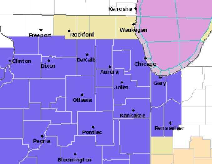
Winter Weather Advisory URGENT – WINTER WEATHER MESSAGE National Weather Service Chicago IL 217 PM CST Fri Jan 7 2022
ILZ008-010>013-019>021-023-032-033-039-103>108-INZ001-002-010-011- 080430- /O.NEW.KLOT.WW.Y.0002.220108T1900Z-220109T0300Z/ Ogle-Lee-De Kalb-Kane-DuPage-La Salle-Kendall-Grundy-Kankakee- Livingston-Iroquois-Ford-Northern Cook-Central Cook-Southern Cook- Northern Will-Southern Will-Eastern Will-Lake IN-Porter-Newton- Jasper- Including the cities of Rochelle, Oregon, Byron, Dixon, DeKalb, Sycamore, Aurora, Elgin, Naperville, Wheaton, Downers Grove, Lombard, Carol Stream, Ottawa, Streator, La Salle, Mendota, Marseilles, Oswego, Yorkville, Plano, Morris, Coal City, Minooka, Kankakee, Bourbonnais, Bradley, Pontiac, Dwight, Fairbury, Watseka, Gilman, Paxton, Gibson City, Evanston, Des Plaines, Schaumburg, Palatine, Northbrook, Chicago, Cicero, Oak Lawn, Oak Park, La Grange, Calumet City, Oak Forest, Lemont, Orland Park, Park Forest, Joliet, Bolingbrook, Plainfield, Mokena, Channahon, Manhattan, Wilmington, Crete, Peotone, Beecher, Gary, Hammond, Merrillville, Portage, Valparaiso, Chesterton, Roselawn, Kentland, Morocco, Rensselaer, and DeMotte 217 PM CST Fri Jan 7 2022
…WINTER WEATHER ADVISORY IN EFFECT FROM 1 PM TO 9 PM CST SATURDAY…
* WHAT…Freezing drizzle or light freezing rain expected. Total ice accumulations of up to one tenth of an inch.
* WHERE…Portions of central, east central, north central and northeast Illinois, and northwest Indiana.
* WHEN…From 1 PM to 9 PM CST Saturday.
* IMPACTS…Difficult travel conditions are possible due to icy roads. Secondary roads, bridges and overpasses, parking lots, and sidewalks are most susceptible.
* ADDITIONAL DETAILS…Even as air temperatures gradually climb to above freezing during Saturday evening, ground and pavement temperatures may lag that, resulting in icy conditions on untreated surfaces.
PRECAUTIONARY/PREPAREDNESS ACTIONS…
Slow down and use caution while traveling.
In Illinois, the latest road conditions for Illinois can be obtained on the internet at www.gettingaroundillinois.com. In Indiana, the latest road conditions for Indiana are available by calling 1-800-261-7623.
O’HARE FORECAST …
Tonight: Partly cloudy, with a temperature rising to around 12 by 4am. Wind chill values as low as -6. South wind 5 to 15 mph, with gusts as high as 20 mph.
Saturday: A chance of freezing drizzle, mainly after 3pm. Increasing clouds, with a high near 32. Wind chill values as low as -1. South wind around 15 mph, with gusts as high as 30 mph.
Saturday Night: Drizzle or freezing drizzle likely before midnight, then a slight chance of drizzle between midnight and 3am. Cloudy, with a low around 22. South southwest wind 10 to 15 mph becoming west northwest after midnight. Winds could gust as high as 25 mph.
Sunday: Mostly cloudy through mid morning, then gradual clearing, with a high near 28. Northwest wind 10 to 15 mph, with gusts as high as 25 mph.
Sunday Night: A 30 percent chance of snow after midnight. Partly cloudy, with a low around 7. West wind around 10 mph, with gusts as high as 15 mph.
Monday: A 30 percent chance of snow before noon. Mostly sunny, with a high near 14.
Monday Night: Mostly clear, with a low around -1.
Tuesday: Sunny, with a high near 25.
Tuesday Night: Mostly cloudy, with a low around 19.
Wednesday: Partly sunny, with a high near 38.
Wednesday Night: Mostly cloudy, with a low around 27.
Thursday: Partly sunny, with a high near 38.
Thursday Night: Mostly cloudy, with a low around 28.
Friday: A chance of rain and snow. Mostly cloudy, with a high near 36.
LAKE TEMPS …
SOUTHERN LAKE MICHIGAN WATER TEMPERATURES
NATIONAL WEATHER SERVICE CHICAGO/ROMEOVILLE IL
904 AM CST Fri Jan 7 2022
LAKE MICHIGAN WATER TEMPERATURES…
CHICAGO SHORE……….36.
CHICAGO CRIB……….37.
MICHIGAN CITY……….38.
&&
M IS FOR MISSING DATA THAT IS NORMALLY AVAILABLE.
THE MICHIGAN CITY WATER TEMPERATURE SENSOR IS LOCATED AT A WATER
INTAKE ONE MILE OFFSHORE AND 60 FEET BELOW WATER SURFACE. IT IS READ
EVERY DAY OF THE YEAR.
january.chicagoweatherstation.com
Chicago Weather Forecast for your MAC/PC/TABLET includes surrounding suburbs.
^^ MOBILE? USE VOICE MIC ^^
facebook …
Please ‘LIKE’ the ‘Arlington Cardinal Page. See all of The Cardinal Facebook fan pages at Arlingtoncardinal.com/about/facebook …
Help fund The Cardinal Arlingtoncardinal.com/sponsor
20240105-1435future
