
Winter Weather Advisory Extended from 9PM to Midnight
Untreated roadways, sidewalks, and parking lots are becoming slippery as freezing drizzle falls across our area. Take it slow whether by foot or car out there!
— NWS Chicago
The continued forecast message continues with no major changes this afternoon and evening, while the Winter Weather Advisory was expanded to include the Wisconsin stateline region, and the Advisory as a whole was extended through midnight.
- Patchy freezing drizzle will become more widespread, and in some locations, more steady by 5 PM, with scattered freezing rain showers along and south of the Kankakee River Valley.
- Light glaze developing on untreated surfaces and some treated ones too given the cold ground conditions; the primary treated surfaces will likely have less impacts, such as in the heart of the Chicago metro, but the extent of icing will depend on the drizzle rates and treatment effectiveness.
- Freezing drizzle/light freezing rain will continue until 8 PM to midnight depending on location (earlier west and south and later north and east). Some fog is also possible later this evening mainly along and south of I-80.
- Blustery and colder on Sunday with temperatures inching downward through the day; wind chills of -5°F to 5°F from late morning and later.
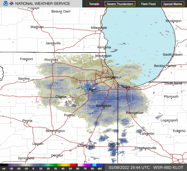
Weather Radar shows precipitation moving southwest to northeast in northeast Illinois at 3:35 p.m. and 4:50 p.m.
See also Arlingtoncardinal.com/clouds
Radar and observations, including mPing reports, have shown an expansion of freezing drizzle over northern Illinois since 130 PM. Recent AMDAR soundings from MDW show the saturated depth about 3,000 ft thick, sufficient for drizzle. Would expect as cloud bases lower (aided by virga at first), the drizzle coverage should become fairly widespread by 5 PM on continued modest to strong isentropic ascent within that saturated layer. The peak coverage of rain/drizzle looks to be during the early evening hours for our CWA, with 50-55 kt of moisture transport on the low-level jet over the area. This could result in some true freezing rain showers such as seen earlier in central Illinois, according to NWS Chicago.
Air temperatures through early evening in most places look to remain below freezing, with the 32 isotherm near I-70 still as of 230 PM. The temperatures of the warmest part of the saturated layer aloft on AMDAR data indicate around 1 to 1.5C, so not super warm hydrometeors which can help with light icing as they reach the surface. Pavement temperatures on a handful of available area sensors have inched upward, with mid 20s in far northern Illinois and around 30 in northwest Indiana. With sunset, would expect pavement temperatures to dip a bit, even if climbing above freezing the next couple hours. So the early evening, roughly 5 to 9 PM, seems when impacts of this event should be maximized. Also the winds ease some, where as of 230 PM they almost seem breezy enough to dry some of the surfaces readily given the lightness and non-steadiness of the current drizzle.
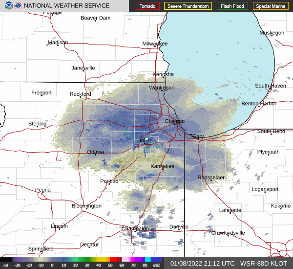
According to the NWS Chicago, the system driving this long fetch of low-level moisture transport atop the Mississippi River Valley into the Great Lakes will be speeding east across Ontario tonight and bringing a cold front toward the area. Ahead of this front during the late evening, two deterrents to freezing precipitation will come into the play: 1.) the warm sector will inch northward and 2.) drying/diminished isentropic ascent will spread eastward. These will not be everywhere though, and some freezing drizzle is still expected north of the 32 isotherm where it is still moist enough. This includes in parts of the Chicago metro. So felt the need to extend the Advisory until midnight, but do think some areas will have the threat diminished by 9 to 10 P.M., namely the far south. Areas of fog could develop with the boundary layer saturation and dew points pushing up close to freezing late in the evening into early overnight. This is mainly for along and south of I-80.
The surface cold front will progress through the area in the pre- dawn to daybreak hours, ending precipitation chances and bringing clearing skies a few hours after passage. Northwest winds will gust to 25 to 30 mph through much of the day bringing cold advection and sending temperatures into the teens and lower 20s for the late morning and afternoon.
Beautiful windshield after freezing drizzle in Arlington Heights, Illinois, but impossible to see through without scraping @weatherchannel @jimcantore @NWSChicago @FoxWeather @JaniceDean pic.twitter.com/bar3xkhUHP
— Cardinal News (@EarlyReport) January 8, 2022
First scrape: Beautiful windshield after freezing drizzle in Arlington Heights, Illinois, but impossible to see through without scraping @weatherchannel @jimcantore @NWSChicago @FoxWeather @JaniceDean pic.twitter.com/iB9t7DimLe
— Cardinal News (@EarlyReport) January 8, 2022
The @WeatherBug camera in Herscher (southwest Kankakee County) is pointed to the west. Notice the ice build up on the left side of the camera dome. @NWSChicago #ILwx pic.twitter.com/d5wa40Z5E8
— Mike Janssen (@MikeJanssenWX) January 8, 2022
With freezing drizzle now spreading into northern Illinois and northwestern Illinois, let is know what you're seeing! mPing is a free, easy app to send precipitation reports to the NWS. More information is below: #ilwx #inwx pic.twitter.com/Ea4tWZ3ID1
— NWS Chicago (@NWSChicago) January 8, 2022
https://twitter.com/NWSChicago/status/1479852899500920832
https://twitter.com/NWSChicago/status/1479824331127545858
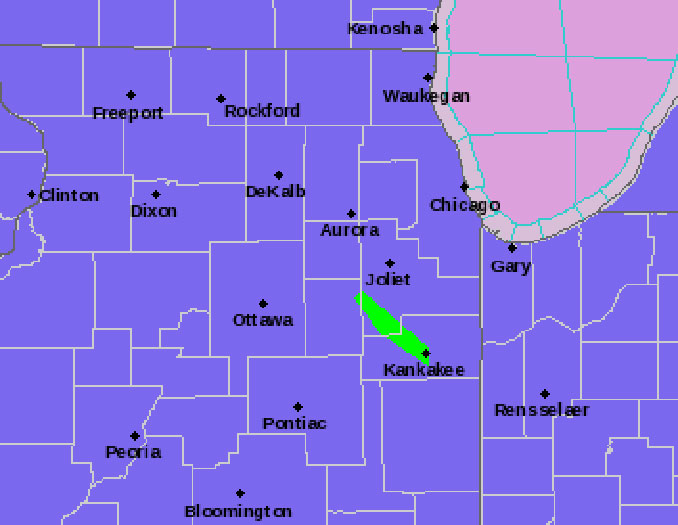
Winter Weather Advisory URGENT – WINTER WEATHER MESSAGE National Weather Service Chicago IL 136 PM CST Sat Jan 8 2022
ILZ008-010>013-019>021-023-032-033-039-103>108-INZ001-002-010-011- 019-090345- /O.EXT.KLOT.WW.Y.0002.000000T0000Z-220109T0600Z/ Ogle-Lee-De Kalb-Kane-DuPage-La Salle-Kendall-Grundy-Kankakee- Livingston-Iroquois-Ford-Northern Cook-Central Cook-Southern Cook- Northern Will-Southern Will-Eastern Will-Lake IN-Porter-Newton- Jasper-Benton- Including the cities of Rochelle, Oregon, Byron, Dixon, DeKalb, Sycamore, Aurora, Elgin, Naperville, Wheaton, Downers Grove, Lombard, Carol Stream, Ottawa, Streator, La Salle, Mendota, Marseilles, Oswego, Yorkville, Plano, Morris, Coal City, Minooka, Kankakee, Bourbonnais, Bradley, Pontiac, Dwight, Fairbury, Watseka, Gilman, Paxton, Gibson City, Evanston, Des Plaines, Schaumburg, Palatine, Northbrook, Chicago, Cicero, Oak Lawn, Oak Park, La Grange, Calumet City, Oak Forest, Lemont, Orland Park, Park Forest, Joliet, Bolingbrook, Plainfield, Mokena, Channahon, Manhattan, Wilmington, Crete, Peotone, Beecher, Gary, Hammond, Merrillville, Portage, Valparaiso, Chesterton, Roselawn, Kentland, Morocco, Rensselaer, DeMotte, Fowler, and Oxford 136 PM CST Sat Jan 8 2022 /236 PM EST Sat Jan 8 2022/
…WINTER WEATHER ADVISORY NOW IN EFFECT UNTIL MIDNIGHT CST /1 AM EST/ TONIGHT…
* WHAT…Freezing drizzle or light freezing rain expected. Total ice accumulations of up to one tenth of an inch.
* WHERE…Portions of central, east central, north central and northeast Illinois, and northwest Indiana.
* WHEN…Until midnight CST /1 AM EST/ tonight.
* IMPACTS…Hazardous travel conditions expected due to a light glaze on roadways. Secondary roads, bridges and overpasses, parking lots, and sidewalks are most susceptible.
* ADDITIONAL DETAILS…Even as air temperatures gradually climb to above freezing this evening for some locations, ground and pavement temperatures may lag that, resulting in slick conditions on untreated surfaces.
PRECAUTIONARY/PREPAREDNESS ACTIONS…
Slow down and use caution while traveling.
In Illinois, the latest road conditions for Illinois can be obtained on the internet at www.gettingaroundillinois.com. In Indiana, the latest road conditions for Indiana are available by calling 1-800-261-7623.
O’HARE FORECAST …
Tonight: Rain or freezing rain likely before 2am, then a slight chance of freezing drizzle between 2am and 3am. Cloudy, with a low around 22. South wind 10 to 15 mph becoming west northwest after midnight. Winds could gust as high as 25 mph. Chance of precipitation is 70%. Total nighttime ice accumulation of less than a 0.1 of an inch possible.
Sunday: Mostly cloudy, then gradually becoming sunny, with a temperature falling to around 14 by 5pm. Wind chill values as low as -1. Blustery, with a northwest wind 15 to 20 mph, with gusts as high as 30 mph.
Sunday Night: A 30 percent chance of snow, mainly after 3am. Increasing clouds, with a low around 8. Wind chill values as low as -4. West wind 10 to 15 mph.
Monday: A 40 percent chance of snow before noon. Cloudy through mid morning, then gradual clearing, with a high near 15. Wind chill values as low as -3. Northwest wind 10 to 15 mph, with gusts as high as 20 mph.
Monday Night: Mostly clear, with a low around 0. Northwest wind 5 to 10 mph.
Tuesday: Sunny, with a high near 28.
Tuesday Night: Partly cloudy, with a low around 22.
Wednesday: Partly sunny, with a high near 37.
Wednesday Night: Mostly cloudy, with a low around 25.
Thursday: Partly sunny, with a high near 36.
Thursday Night: Mostly cloudy, with a low around 28.
Friday: A chance of rain and snow. Mostly cloudy, with a high near 38.
Friday Night: A chance of rain and snow. Cloudy, with a low around 27.
Saturday: A chance of snow. Mostly cloudy, with a high near 33.
LAKE TEMPS …
SOUTHERN LAKE MICHIGAN WATER TEMPERATURES
NATIONAL WEATHER SERVICE CHICAGO/ROMEOVILLE IL
908 AM CST Sat Jan 8 2022
LAKE MICHIGAN WATER TEMPERATURES…
CHICAGO SHORE……….40.
CHICAGO CRIB……….39.
MICHIGAN CITY……….36.
&&
M IS FOR MISSING DATA THAT IS NORMALLY AVAILABLE.
THE MICHIGAN CITY WATER TEMPERATURE SENSOR IS LOCATED AT A WATER
INTAKE ONE MILE OFFSHORE AND 60 FEET BELOW WATER SURFACE. IT IS READ
EVERY DAY OF THE YEAR.
january.chicagoweatherstation.com
Chicago Weather Forecast for your MAC/PC/TABLET includes surrounding suburbs.
^^ MOBILE? USE VOICE MIC ^^
facebook …
Please ‘LIKE’ the ‘Arlington Cardinal Page. See all of The Cardinal Facebook fan pages at Arlingtoncardinal.com/about/facebook …
Help fund The Cardinal Arlingtoncardinal.com/sponsor
20240105-1435future
