
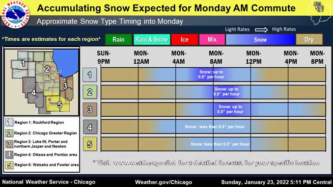
The NWS Office Chicago has opted to issue an impact-based Winter Weather Advisory due to the forecasted poor arrival time of accumulating snowfall affecting the morning Rush Hour. The weather system is forecast to affect much of northern Illinois and northwestern Indiana, including the Rockford and Chicago metro areas, late tonight into Monday due to the poor arrival time of another wave of accumulating snow.
The Winter Weather Advisory was issued to act as an additional heads up information for those traveling Monday morning — specifically that travel conditions will be poor across the area.
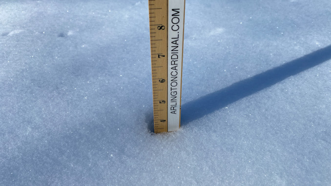
Low rate snowfall and flurries are forecast to begin in Arlington Heights about 1:00 a.m. and transition to high-rate snowfall between 4:00 a.m. and 5:00 a.m. Monday January 24, 2022. Snowfall is forecast to continue at high-rate until around 11:00 a.m. Monday, but snow accumulation at 6:00 a.m. is only expected to be about 0.6 inch at the beginning of fairly rapid accumulation (0.5″ per hour) through the rest of rush hour. Total accumulation in Arlington Heights for this snow system is expected to be about 2.5 inches ending about 2:00 p.m. Total snow cover is expected to be about 6 inches after getting hit by these two clipper systems.
This second fast moving clipper system shifted into the Dakotas early Sunday afternoon and will shift southeastward into our area Monday morning. Snow is expected to move into northern Illinois late tonight after midnight in response to increasing deep low-to-mid level warm air advection (isentropic upglide or warm air blowing above cold air below) tied to the approaching disturbance.
Periods of steady snow will onset right at the start of the Monday morning rush and continue through most of the morning. While signs do not point to us getting quite as much snow as we just had this morning, there is some concern for some shorter bursts of higher snow rates. This may thus result in a couple inches of accumulation (2-3″) before the snow begins to abate across my IL counties by early afternoon.
In northwest Indiana, the snow will continue early in the afternoon and some lake effect snow showers could even persist across parts of Porter county Indiana into the evening. The Winter Weather Advisory was issued to act as an additional heads up information for those traveling Monday morning — specifically that travel conditions will be poor across the area. Conditions should improve across most areas into the afternoon.
There will be a push of cold arctic air into the area in the wake of this clipper system Monday night into Tuesday as a large 1040 mb surface high drops southward into the Mid-Mississippi Valley. The cold airmass combined with the fresh snow cover will result in very cold surface temperatures and dangerous wind chills for Tuesday and Wednesday. High temperatures both days (Tuesday and Wednesday) will likely be in the lower teens, with overnight lows dropping well below zero Tuesday night as the surface high shifts overhead. Wind chills Tuesday morning around 4:00 a.m. could be as low as -9°F in Arlington Heights, and around 4:00 a.m. Wednesday could be as low as -20°F.
Winds will be around 20 MPH from 2:00 a.m. Monday to around 10:00 a.m. Tuesday.
Weather Radar shows early precipitation moving northwest to southeast but west of Interstate 39 at 8:50 a.m.
Weather Radar in northeast Illinois was clear.
See also Arlingtoncardinal.com/clouds
Brrrrr! Clear skies, light winds, and a fresh snowpack (for some) are leading to chilly temperatures with many readings currently in the single digits. Clouds will cover our area by midnight which should stop the tumble in temperatures. Bundle up if heading out! #ilwx #inwx pic.twitter.com/WpFi640eD1
— NWS Chicago (@NWSChicago) January 24, 2022
Another round of snow will move across our area tomorrow including during the morning commute. The snow will be heavier and more dense than what fell today with amounts of 2-3" especially in the red shaded area. Take it slow on ice and snow! #ilwx #inwx pic.twitter.com/zjJij4S5eB
— NWS Chicago (@NWSChicago) January 23, 2022
Hey @Chicago! It looks like it is a little chilly down there. This view of you all was captured live from the @Space_Station 260 miles above at 4:40PM CST today!
Is there some ice building up over the lake?@NWSChicago @ABC7Chicago @WGNNews @nbcchicago @fox32news
(Jan 23, 2022) pic.twitter.com/I74aa8tKgY— ISS Above (@ISSAboveYou) January 24, 2022
Winter Weather Advisory URGENT – WINTER WEATHER MESSAGE National Weather Service Chicago IL 801 PM CST Sun Jan 23 2022
ILZ003>006-008-011>013-020-021-023-103>108-241015- /O.CON.KLOT.WW.Y.0005.220124T0900Z-220124T1800Z/ Winnebago-Boone-McHenry-Lake IL-Ogle-De Kalb-Kane-DuPage-Kendall- Grundy-Kankakee-Northern Cook-Central Cook-Southern Cook- Northern Will-Southern Will-Eastern Will- Including the cities of Rockford, Belvidere, Crystal Lake, Algonquin, McHenry, Woodstock, Waukegan, Buffalo Grove, Mundelein, Gurnee, Rochelle, Oregon, Byron, DeKalb, Sycamore, Aurora, Elgin, Naperville, Wheaton, Downers Grove, Lombard, Carol Stream, Oswego, Yorkville, Plano, Morris, Coal City, Minooka, Kankakee, Bourbonnais, Bradley, Evanston, Des Plaines, Schaumburg, Palatine, Northbrook, Chicago, Cicero, Oak Lawn, Oak Park, La Grange, Calumet City, Oak Forest, Lemont, Orland Park, Park Forest, Joliet, Bolingbrook, Plainfield, Mokena, Channahon, Manhattan, Wilmington, Crete, Peotone, and Beecher 801 PM CST Sun Jan 23 2022
…WINTER WEATHER ADVISORY REMAINS IN EFFECT FROM 3 AM TO NOON CST MONDAY…
* WHAT…Snow and hazardous travel conditions expected. Total snow accumulations of 2 to 3 inches are expected.
* WHERE…Portions of north central and northeast Illinois.
* WHEN…From 3 AM to noon CST Monday.
* IMPACTS…Plan on slippery road conditions.
* ADDITIONAL DETAILS…Snow will begin late tonight, with the highest snowfall rates expected during the Monday morning commute. Slow and hazardous travel is likely during the Monday morning commute.
PRECAUTIONARY/PREPAREDNESS ACTIONS…
Slow down and use caution while traveling.
The latest road conditions for Illinois can be obtained on the internet at www.gettingaroundillinois.com.
O’HARE FORECAST …
Tonight: Snow, mainly after 3am. Temperature falling to near 7 by 10pm, then rising to around 17 during the remainder of the night. Wind chill values as low as -3. South southwest wind 5 to 10 mph, with gusts as high as 15 mph. Chance of precipitation is 100%. Total nighttime snow accumulation of less than one inch possible.
Monday: Snow, mainly before noon. High near 27. South wind 5 to 15 mph becoming north northwest in the afternoon. Winds could gust as high as 20 mph. Chance of precipitation is 100%. New snow accumulation of 1 to 3 inches possible.
Monday Night: Partly cloudy, with a low around 4. Wind chill values as low as -9. Northwest wind 10 to 15 mph, with gusts as high as 20 mph.
Tuesday: Sunny, with a high near 12. Wind chill values as low as -10. Northwest wind 10 to 15 mph.
Tuesday Night: Mostly clear, with a low around -7. West northwest wind around 10 mph.
Wednesday: Sunny, with a high near 14.
Wednesday Night: Mostly cloudy, with a low around 8.
Thursday: A chance of snow after noon. Mostly cloudy, with a high near 32.
Thursday Night: A chance of snow before midnight. Mostly cloudy, with a low around 9.
Friday: Mostly sunny, with a high near 21.
Friday Night: Partly cloudy, with a low around 7.
Saturday: Mostly sunny, with a high near 27.
Saturday Night: Mostly cloudy, with a low around 17.
Sunday: Mostly cloudy, with a high near 32.
LAKE TEMPS …
SOUTHERN LAKE MICHIGAN WATER TEMPERATURES
NATIONAL WEATHER SERVICE CHICAGO/ROMEOVILLE IL
939 AM CST Sat Jan 22 2022
LAKE MICHIGAN WATER TEMPERATURES…
CHICAGO SHORE………33.
CHICAGO CRIB……….33.
MICHIGAN CITY……….33.
&&
M IS FOR MISSING DATA THAT IS NORMALLY AVAILABLE.
THE MICHIGAN CITY WATER TEMPERATURE SENSOR IS LOCATED AT A WATER
INTAKE ONE MILE OFFSHORE AND 60 FEET BELOW WATER SURFACE. IT IS READ EVERY DAY OF THE YEAR.
january.chicagoweatherstation.com
Chicago Weather Forecast for your MAC/PC/TABLET includes surrounding suburbs.
^^ MOBILE? USE VOICE MIC ^^
facebook …
Please ‘LIKE’ the ‘Arlington Cardinal Page. See all of The Cardinal Facebook fan pages at Arlingtoncardinal.com/about/facebook …
Help fund The Cardinal Arlingtoncardinal.com/sponsor
20240105-1435future
