
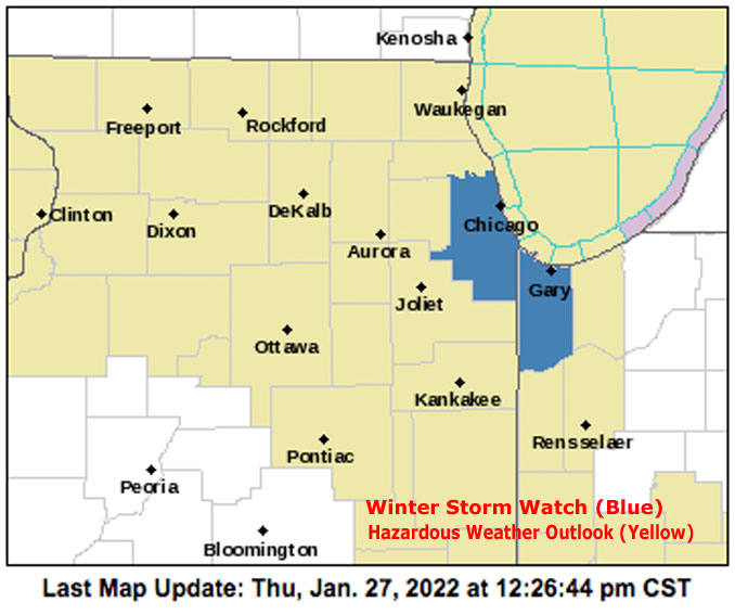
A Winter Storm Watch for Cook County does NOT include Arlington Heights and the northwest suburbs. No significant accumulation is forecast for Arlington Heights and surrounding suburbs. You may received an alert, but the Winter Storm Watch does NOT include north and northwest Cook County — north of Route 390 and Devon Avenue and west of I-294. Some snow accumulation is possible near the Lake Michigan shoreline in Cook County and north into Lake County, Illinois.
Blustery southwest winds will bring milder temperatures to the area today, followed by a cold front later today. No significant precipitation is expected ahead around the immediate passage of a Cold Front other than perhaps a few flurries. However, the return of arctic air and a shift to blustery north-northeast winds tonight is expected to bring the potential for locally heavy lake-effect snow to parts of northwest Indiana and perhaps even the southeast side of Chicago before weakening Friday.
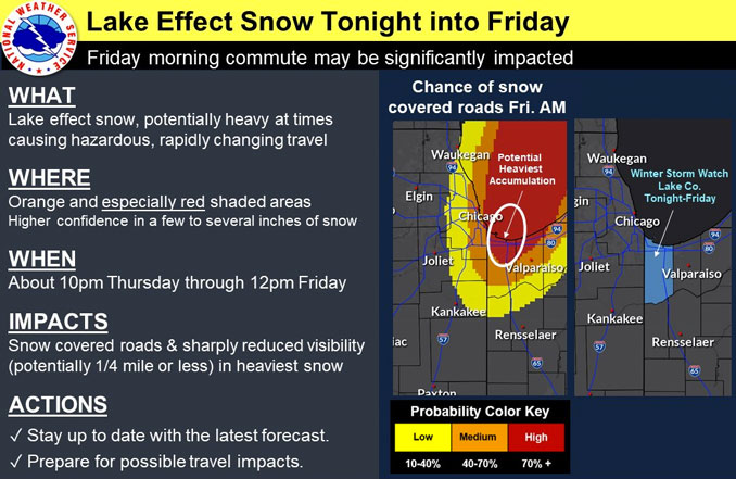
Significant precipitation potential develops this evening in southern Cook County, as low level winds turn northerly behind the front, and cold arctic air spreads back across the region. Forecast soundings indicate lake to 850 mb deltas increase to about 18C tonight, with much of the convective cloud depth residing in the favored dendritic growth region between -12C and -18C. Strong single-band convergent signal noted in guidance, with maximized fetch from north to south or south-southwest down the lake. High-res guidance depicts this band becoming organized near the Lake/Porter county border and then edging west across Lake county overnight and into Friday morning before winds eventually diminish and back more northwest Friday afternoon. This largely places the focus for a potential 6+ inch accumulation across Lake County, Indiana, which prompted the NWS Office Chicago to issue a winter storm watch from Thursday evening through early afternoon on Friday. The forecast models indicated a possible shift of the band a little farther west across the IL/IN state line and into southeastern Cook county for a time Friday morning. An expansion of the watch (or an advisory) may be needed in the Indiana region if the scenario worsens. High-res model runs later today should hopefully continue to narrow the location of greater impacts. In any case, the lake-effect band looks to weaken and lose organization while shifting back east Friday afternoon.
For the rest of Chicagoland, cold and dry conditions will develop tonight across the Illinois portion of the forecast area away from the lake, including the northwest suburbs, west suburbs and other areas west of the city, and west of the Lake Michigan shoreline. Lows will again settle into the single digits by Friday morning, with sub-zero wind chills in most spots though not to the level experienced Wednesday morning. Friday`s temps will generally be in the teens, with wind chills generally from zero into the positive single digits during the day.
— NWS Chicago with CARDINAL NEWS edits
Weather Radar) in northeast Illinois shows light snow showers at 12:10 p.m. moving west to east.
NWStweet? Updated graphic coming soon.
URGENT – WINTER WEATHER MESSAGE National Weather Service Chicago IL 1202 PM CST Thu Jan 27 2022
ILZ104-105-280215- /O.EXB.KLOT.WS.A.0003.220128T0600Z-220128T1800Z/ Central Cook-Southern Cook- Including the cities of Chicago, Cicero, Oak Lawn, Oak Park, La Grange, Calumet City, Oak Forest, Lemont, Orland Park, and Park Forest 1202 PM CST Thu Jan 27 2022
…WINTER STORM WATCH IN EFFECT FROM LATE TONIGHT THROUGH FRIDAY MORNING…
* WHAT…Heavy lake effect snow possible. Total snow accumulations of 2 to 4 inches likely for areas that see lake effect snow. Significant localized snow accumulations of up to 6 inches or more possible.
* WHERE…Central Cook and Southern Cook Counties near the lakeshore.
* WHEN…From late tonight through Friday morning.
* IMPACTS…Plan on slippery road conditions. The hazardous conditions could impact the morning commute. Dangerous, rapidly changing travel conditions possible with lake effect snow showers.
* ADDITIONAL DETAILS…Lake effect snow is expected to develo P tonight and continue into Friday morning. Snowfall rates of 1 to 2 inches per hour along with visibility less than one half mile is possible. It is likely that portions of Chicago away from the lake will likely see little to even no accumulation.
PRECAUTIONARY/PREPAREDNESS ACTIONS…
Monitor the latest forecasts for updates on this situation.
O’HARE FORECAST …
This Afternoon: A chance of flurries before 3pm, then a chance of flurries with a slight chance of snow showers after 3pm. Cloudy, with a high near 31. West wind 10 to 15 mph, with gusts as high as 20 mph. Chance of precipitation is 20%.
Tonight: A 20 percent chance of flurries with a slight chance of snow showers before 9pm. Mostly cloudy, with a low around 9. Wind chill values as low as -5. North northwest wind 10 to 15 mph, with gusts as high as 25 mph.
Friday: A 20 percent chance of snow showers before 9am. Partly sunny, with a high near 18. Wind chill values as low as -5. North northwest wind 5 to 10 mph, with gusts as high as 20 mph.
Friday Night: Mostly clear, with a low around 1. Wind chill values as low as -9. West northwest wind around 5 mph.
Saturday: Mostly sunny, with a high near 23. South wind 5 to 10 mph, with gusts as high as 15 mph.
Saturday Night: Mostly cloudy, with a low around 17.
Sunday: Partly sunny, with a high near 28.
Sunday Night: Mostly cloudy, with a low around 14.
Monday: Mostly sunny, with a high near 35.
Monday Night: Partly cloudy, with a low around 30.
Tuesday: A chance of rain and snow. Mostly cloudy, with a high near 41.
Tuesday Night: Rain and snow. Cloudy, with a low around 29.
Wednesday: Snow likely. Mostly cloudy, with a high near 35.
LAKE TEMPS …
SOUTHERN LAKE MICHIGAN WATER TEMPERATURES
NATIONAL WEATHER SERVICE CHICAGO/ROMEOVILLE IL
909 AM CST Thu Jan 27 2022
LAKE MICHIGAN WATER TEMPERATURES…
CHICAGO SHORE………33.
CHICAGO CRIB……….34.
MICHIGAN CITY……….33.
&&
M IS FOR MISSING DATA THAT IS NORMALLY AVAILABLE.
THE MICHIGAN CITY WATER TEMPERATURE SENSOR IS LOCATED AT A WATER
INTAKE ONE MILE OFFSHORE AND 60 FEET BELOW WATER SURFACE. IT IS READ
EVERY DAY OF THE YEAR.
january.chicagoweatherstation.com
Chicago Weather Forecast for your MAC/PC/TABLET includes surrounding suburbs.
^^ MOBILE? USE VOICE MIC ^^
facebook …
Please ‘LIKE’ the ‘Arlington Cardinal Page. See all of The Cardinal Facebook fan pages at Arlingtoncardinal.com/about/facebook …
Help fund The Cardinal Arlingtoncardinal.com/sponsor
20240105-1435future
