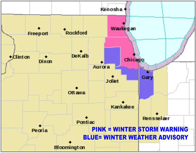
Lake County Illinois Winter Storm Warning, too
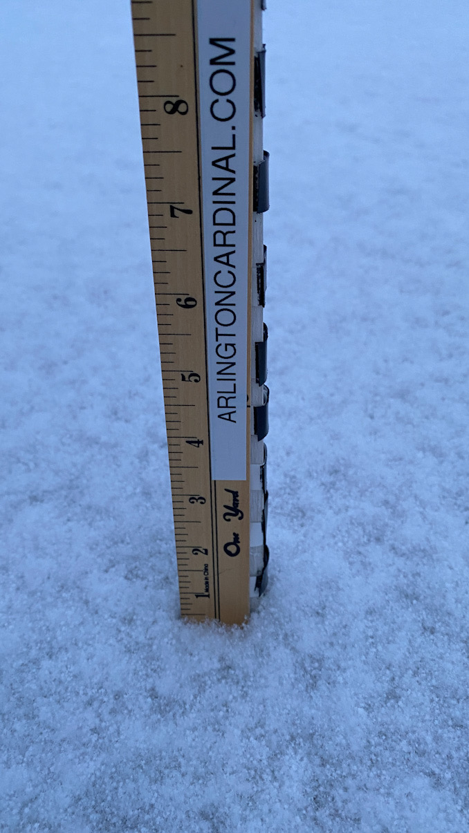
The forecast could shift again, but currently 3.3 inches of snowfall is forecast for Arlington Heights between about 1:00 a.m. and 12:00 p.m. Friday, January 28, 2022.
Compared to this afternoons outlook, the NWS Office Chicago has forecast a shift in the lake effect snow (LES) impact — shifting from northwest Indiana to the City of Chicago, and west and northwest suburbs and Lake County, Illinois. A Winter Storm Warning was issued at 9:13 p.m. for Lake County ILLINOIS, central, and northern Cook Counties. A Winter Weather Advisory is activated for DuPage County, southern Cook County, and Lake County Indiana. This is mostly a flip from the forecast from Thursday afternoon. Lake effect snow bands are difficult to predict, and as the impact time closes in, the snow band is forecast to hit Chicago and suburbs more than Indiana. Snow accumulation forecast remain tentative as the the lake effect snow band could shift impact in northeast Illinois.
Regarding the synoptic and thermodynamic environment for lake effect snow (LES), there are no changes from thinking regarding the intensity of snowfall rates of the previous impact area — it’s just the impact area has moved further north and west in this update. According the the NWS Office Chicago, there is favorable environment for a dominant, intense single lake effect snow band to develop and move ashore into northeast Illinois overnight into Friday morning. Forecast soundings show convective layer encompassing the entire dendritic growth zone (DGZ) and given the strong instability and expected land breeze convergence band, should see strong ascent through the DGZ. Set-up appears favorable for 2″+ per hour snowfall rates during the most intense portion of the LES band (09z-16z).
There has been a near unanimous shift westward shift in high-resolution guidance in the placement of the Lake Effect Snow (LES) band, which places the risk of heavy snow farther north into the Chicagoland metro area instead of northwest Indiana. Unfortunately, there are inherent uncertainties that come into play when trying to forecast meso-gamma scale phenomena like this, according to NWS Chicago. It is also not uncommon for snow bands to “wiggle” around and there is still spread in the various high-resolution guidance on placement of the LES band. While additional shifts in the forecast placement of the band are possible, the NWS reported the time window arrived that a decision needed to be made, so the NWS Office Chicago trended the higher snow accumulations farther north and west, though not as far north and west as most of the 00z high-resolution guidance.
The westward shift in the guidance actually increases confidence that there could be a longer residence time for some areas. In other words, the LES band could sit over areas for a longer time period. Confidence is increasing that maximum snowfall totals somewhere in Chicagoland will end up at least in the 6-8″ range and double digit totals could even occur. Given the timing of this event (during the height of Friday morning rush hour) and the inherent uncertainties in exact placement of the LES band, the NWS Office Chicago opted to err a bit on the side of caution with headlines, saying that it is certainly plausible that the LES band ends up just east of Lake County IL and/or Dupage county, or stays mainly west of Lake County, Indiana. The NWS Office Chicago reported they decided to go with a forecast with least regret was to publish a bigger headline and risk that the headline for some areas would over-estimate rather than under-estimate.
Weather Radar shows snow showers moving mostly north to south in northeast Illinois at 10:54 p.m.
See also Arlingtoncardinal.com/clouds
An intense lake effect snow band is likely to impact portions of the Chicago metropolitan area Friday morning, likely causing significant travel problems during the height of rush hour. #ilwx #inwx pic.twitter.com/5vsNbDtrla
— NWS Chicago (@NWSChicago) January 28, 2022
Lake Effect Snow update:
Observational & model trends show a significant westward shift in the lake effect snow overnight into Fri AM. There is enough observational data to warrant the shift seen in forecast models early this evening [1/3]— NWS Chicago (@NWSChicago) January 28, 2022
Winds across the central/southern Lake MI have become more easterly than previously expected, which is now focusing the developing dominant lake effect band farther west in central Lake MI. This supports an earlier onshore arrival time & a longer residence time in NE IL [2/3]
— NWS Chicago (@NWSChicago) January 28, 2022
Winter Storm Warning: (eastern) Lake (IL), Northern/central Cook. for locally 4-8" through Friday A.M.
Winter Weather Advisory: (eastern) DuPage, S Cook, (northwest) Lake (IN) for locally 2-5" through Friday A.M.
Updated graphics available soon. [3/3]
— NWS Chicago (@NWSChicago) January 28, 2022
Winter Storm Warning URGENT – WINTER WEATHER MESSAGE National Weather Service Chicago IL 913 PM CST Thu Jan 27 2022
ILZ104-281115- /O.UPG.KLOT.WS.A.0003.220128T0600Z-220128T1800Z/ /O.NEW.KLOT.WS.W.0002.220128T0800Z-220128T1800Z/ Central Cook- Including the cities of Chicago, Cicero, Oak Lawn, Oak Park, and La Grange 913 PM CST Thu Jan 27 2022
…WINTER STORM WARNING IN EFFECT FROM 2 AM TO NOON CST FRIDAY…
* WHAT…Heavy lake effect snow expected, with snowfall rates of 2 or more inches per hour possible at times. The highest snow accumulations are likely to end up between 4 and 8 inches. The nature of lake effect snow is such that snow intensity can vary significantly over just a few miles. Locations not directly impacted by the most intense snow band will probably end up with considerably less than 4 inches of snow.
* WHERE…Central Cook County.
* WHEN…From 2 AM to noon CST Friday.
* IMPACTS…Conditions will be highly variable, potentially going from just flurries to near white out conditions in heavy snow over just a few mile stretch. Under the intense snow band, travel will likely be extremely difficult, including during the height of Friday morning rush hour.
* ADDITIONAL DETAILS…The intense portion of the lake effect snow band will result in visibilities of a quarter mile or less and rapid accumulation rates, potentially exceeding 2 inches per hour at times. Snowfall rates of this magnitude, particularly in heavy traffic, can be very difficult for plows to keep up with. If travel cannot be postponed, plan for significantly longer travel times in areas impacted by the most intense snowfall.
PRECAUTIONARY/PREPAREDNESS ACTIONS…
If you must travel, keep an extra flashlight, food, and water in your vehicle in case of an emergency.
The latest road conditions for Illinois can be obtained on the internet at www.gettingaroundillinois.com.
O’HARE FORECAST …
Tonight: Scattered flurries with isolated snow showers before midnight, then snow showers likely, mainly after 3am. Mostly cloudy, with a low around 10. Wind chill values as low as -3. North wind 5 to 10 mph, with gusts as high as 15 mph. Chance of precipitation is 60%. Total nighttime snow accumulation of 1 to 2 inches possible.
Friday: Snow showers likely, mainly before 9am. Partly sunny, with a high near 19. Wind chill values as low as -4. North northwest wind 5 to 10 mph. Chance of precipitation is 70%. New snow accumulation of 1 to 3 inches possible.
Friday Night: Mostly clear, with a low around 0. Wind chill values as low as -7. West northwest wind around 5 mph becoming calm after midnight. Winds could gust as high as 10 mph.
Saturday: Mostly sunny, with a high near 22. Wind chill values as low as -7. Light west southwest wind becoming south southwest 5 to 10 mph in the morning. Winds could gust as high as 15 mph.
Saturday Night: Mostly cloudy, with a low around 17. South wind 5 to 10 mph becoming west northwest after midnight.
Sunday: Partly sunny, with a high near 28.
Sunday Night: Mostly cloudy, with a low around 14.
Monday: Partly sunny, with a high near 34.
Monday Night: Mostly cloudy, with a low around 31.
Tuesday: A chance of rain. Mostly cloudy, with a high near 40.
Tuesday Night: Rain and snow likely, possibly mixed with freezing rain and sleet. Cloudy, with a low around 28.
Wednesday: Snow likely, possibly mixed with freezing rain and sleet. Mostly cloudy, with a high near 33.
Wednesday Night: Snow likely, possibly mixed with freezing rain and sleet. Mostly cloudy, with a low around 20.
Thursday: A chance of snow, freezing rain, and sleet. Mostly cloudy, with a high near 26.
LAKE TEMPS …
SOUTHERN LAKE MICHIGAN WATER TEMPERATURES
NATIONAL WEATHER SERVICE CHICAGO/ROMEOVILLE IL
909 AM CST Thu Jan 27 2022
LAKE MICHIGAN WATER TEMPERATURES…
CHICAGO SHORE………33.
CHICAGO CRIB……….34.
MICHIGAN CITY……….33.
&&
M IS FOR MISSING DATA THAT IS NORMALLY AVAILABLE.
THE MICHIGAN CITY WATER TEMPERATURE SENSOR IS LOCATED AT A WATER
INTAKE ONE MILE OFFSHORE AND 60 FEET BELOW WATER SURFACE. IT IS READ
EVERY DAY OF THE YEAR.
january.chicagoweatherstation.com
Chicago Weather Forecast for your MAC/PC/TABLET includes surrounding suburbs.
^^ MOBILE? USE VOICE MIC ^^
facebook …
Please ‘LIKE’ the ‘Arlington Cardinal Page. See all of The Cardinal Facebook fan pages at Arlingtoncardinal.com/about/facebook …
Help fund The Cardinal Arlingtoncardinal.com/sponsor
20240105-1435future
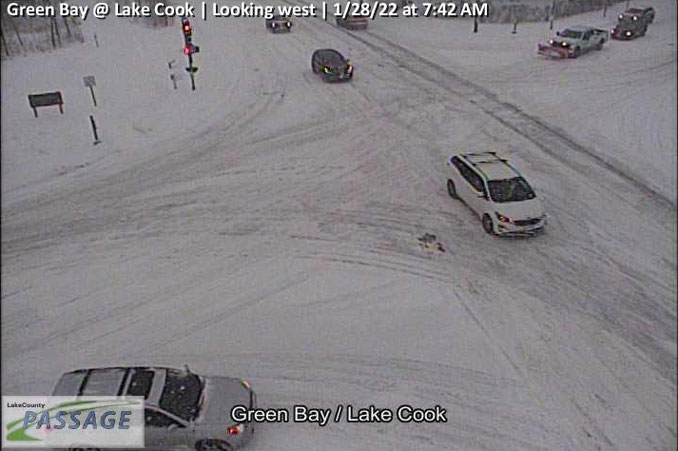
and Green Bay Road Jan. 28, 2022 at 7:42AM CST (SOURCE: Lake County PASSAGE).