
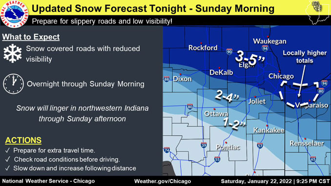
Over 3 inches of dry snow has fallen in Arlington Heights with tapering snowfall rates continuing this morning. Snowfall total may reach around 3.6 to 3.8 inches by 8:00 a.m. to 9:00 a.m.
According to the NWS Chicago, forecast trends look on track with snow ending across the western County Warning Area about daybreak and then across the eastern area by mid/late morning. Temperatures are warmer into the lower/mid 30s southwest of the surface low, which was in northwest Illinois around 3:00 a.m. and moved to northwest Indiana by 5:30 a.m. Most of northeast Illinois was in the low 20s and teens at 5:30 a.m. A Sunday mid-afternoon high of only 20°F is forecast for Arlington Heights.
The earlier warmer temps may have allowed roads to become wet and slushy, but the slush and surfaces are quickly freezing as much colder air returns to Chicagoland.
Some low drifting or blowing snow is possible, mainly across the northern County Warning Area where the snow remains drier. Confidence is low that blowing snow will be a serious issue because most snowfall will be complete before winds pick up. Wind gusts in the mid 20 mph range can be expected this morning, but will steadily diminish by early afternoon. Wind gusts of 20 to 24 MPH are forecast for 6:00 a.m. to 11:00 a.m.
Lake Effect Snow of up to 2-3 inches is possible in eastern Cook County and eastern Will County by noon. However 1-2 inches of Lake Effect Snow is the expectation in eastern Cook and Will counties. The Lake Effect Snow will transition to northwest Indiana, and is expected to end there about 5:00 p.m.
Weather Radar shows snow is is moving southeast and dissipating at 5:45 a.m. Most of Lake County and McHenry County were covered by the end and trailing edge of the radar image.
See also Arlingtoncardinal.com/clouds
https://twitter.com/ohareaviation/status/1485212077119651842
https://twitter.com/ohareaviation/status/1485212586735976456
Light snow will end this morning. Lake effect snow possible for eastern Cook and eastern Will Counties this morning, then far northwest IN this afternoon. Very cold temperatures midweek. #ILWX #INWX pic.twitter.com/MK6SyHJfLf
— NWS Chicago (@NWSChicago) January 23, 2022
Light snow is expected late tonight into Monday. Untreated surfaces will become snow covered and slippery. #ILWX #INWX pic.twitter.com/zOdn0iqNtc
— NWS Chicago (@NWSChicago) January 23, 2022
Snow will taper off from west to east early this AM, though roads over much of northern IL and NW IN are snow covered and slick. Additional lake effect snow may linger this morning from Chicago southeast into NW IN. If traveling this morning, allow extra time. #ilwx #inwx pic.twitter.com/1KPp8gnyu4
— NWS Chicago (@NWSChicago) January 23, 2022
Shovel report
(YES I’m THAT neighbor)
Between 2-3” on NW side of #Chicago
NOT snowball making snow
Very lite and fluffy but just enough too much to use a broom
But if you have a leaf blower…
Back edge west of city, lake effect in blue circled lingers east of Cicero/IL50 pic.twitter.com/idy4NC7QAs
— WindyCity Weather and News (@WindyCityWxMan) January 23, 2022
Lake effect scraggly bands showing up off Milwaukee WI early AM will make their way toward #Chicago about sunrise
Not a lot but should keep flurries and maybe a moderate swipe to mid morning in the city especially S/SE sideshttps://t.co/QE8y0JTzho pic.twitter.com/kegB07hzk2
— WindyCity Weather and News (@WindyCityWxMan) January 23, 2022
Winter Weather Advisory URGENT – WINTER WEATHER MESSAGE National Weather Service Chicago IL 603 AM CST Sun Jan 23 2022
ILZ104-105-108-231800- /O.CON.KLOT.WW.Y.0004.000000T0000Z-220123T1800Z/ Central Cook-Southern Cook-Eastern Will- Including the cities of Chicago, Cicero, Oak Lawn, Oak Park, La Grange, Calumet City, Oak Forest, Lemont, Orland Park, Park Forest, Crete, Peotone, and Beecher 603 AM CST Sun Jan 23 2022
…WINTER WEATHER ADVISORY REMAINS IN EFFECT UNTIL NOON CST TODAY…
* WHAT…Snow. Additional snow accumulations up to one inch.
* WHERE…Eastern Will, Central Cook and Southern Cook Counties.
* WHEN…Until noon CST today.
* IMPACTS…Plan on slippery road conditions.
* ADDITIONAL DETAILS…Lake effect snow is possible across eastern Cook and eastern Will Counties late this morning. If this lake effect snow develops, an additional 1 to 3 inches of snow is possible.
PRECAUTIONARY/PREPAREDNESS ACTIONS…
Slow down and use caution while traveling.
The latest road conditions for Illinois can be obtained on the internet at www.gettingaroundillinois.com.
O’HARE FORECAST …
Today: Snow likely, mainly before 9am. Cloudy through mid morning, then gradual clearing, with a high near 21. North wind 5 to 15 mph becoming west northwest in the afternoon. Winds could gust as high as 25 mph. Chance of precipitation is 70%. Total daytime snow accumulation of less than one inch possible.
Tonight: Snow, mainly after midnight. Low around 13. West northwest wind 5 to 15 mph becoming south southwest after midnight. Winds could gust as high as 20 mph. Chance of precipitation is 90%. New snow accumulation of less than a half inch possible.
Monday: Snow, possibly mixing with freezing drizzle after 2pm, then gradually ending. High near 30. South southwest wind 10 to 15 mph becoming north northwest in the afternoon. Winds could gust as high as 20 mph. Chance of precipitation is 90%. Little or no ice accumulation expected. New snow accumulation of 1 to 2 inches possible.
Monday Night: Partly cloudy, with a low around 5. Wind chill values as low as -7. Northwest wind around 10 mph, with gusts as high as 15 mph.
Tuesday: Sunny, with a high near 13. West northwest wind around 10 mph, with gusts as high as 15 mph.
Tuesday Night: Partly cloudy, with a low around -5.
Wednesday: Sunny, with a high near 14.
Wednesday Night: Partly cloudy, with a low around 7.
Thursday: A slight chance of snow after noon. Mostly cloudy, with a high near 30.
Thursday Night: A slight chance of snow before midnight. Mostly cloudy, with a low around 16.
Friday: Partly sunny, with a high near 26.
Friday Night: Partly cloudy, with a low around 8.
Saturday: Mostly sunny, with a high near 27.
LAKE TEMPS …
SOUTHERN LAKE MICHIGAN WATER TEMPERATURES
NATIONAL WEATHER SERVICE CHICAGO/ROMEOVILLE IL
939 AM CST Sat Jan 22 2022
LAKE MICHIGAN WATER TEMPERATURES…
CHICAGO SHORE………33.
CHICAGO CRIB……….33.
MICHIGAN CITY……….33.
&&
M IS FOR MISSING DATA THAT IS NORMALLY AVAILABLE.
THE MICHIGAN CITY WATER TEMPERATURE SENSOR IS LOCATED AT A WATER INTAKE ONE MILE OFFSHORE AND 60 FEET BELOW WATER SURFACE. IT IS READ
EVERY DAY OF THE YEAR.
january.chicagoweatherstation.com
Chicago Weather Forecast for your MAC/PC/TABLET includes surrounding suburbs.
^^ MOBILE? USE VOICE MIC ^^
facebook …
Please ‘LIKE’ the ‘Arlington Cardinal Page. See all of The Cardinal Facebook fan pages at Arlingtoncardinal.com/about/facebook …
Help fund The Cardinal Arlingtoncardinal.com/sponsor
20240105-1435future
