
Deepest Track May Pass Just South of O’Hare; Accumulation Forecasts for Chicago Area
Above seasonal temperatures and a quiet period are coming for Thursday night and Friday, except for some possible fog and freezing fog in the suburbs where some areas will see visibility reduced to less than one mile. A small chance of drizzle is also possible Thursday night.
The forecasted snow accumulation has trended upward the last three times CARDINAL NEWS checked with National Weather Service data in the past 14 hours. Arlington Heights and nearby suburbs are currently faced with a forecast of 8.6 inches of snow falling between 6:00 a.m. Saturday and 5:00 a.m. Sunday. The highest rate of snowfall is forecast to occur between noon and 6:00 p.m. with a slightly lower rate of snowfall forecast from 6:00 p.m. to 11:00 p.m.
Here is the snow accumulation forecast, which is subject to change as the storm track might change, and especially since the expected snow arrival is still almost 36 hours from publication of this article.
Arlington Heights
8.6″ from 6AM Saturday to 5AM Sunday
Antioch
7.4″ from 6AM Saturday to 5AM Sunday
Aurora
6.4″ from 6AM Saturday to 5AM Sunday
Brookfield Zoo
9.1″ from 6AM Saturday to 5AM Sunday
Des Plaines
8.8″ from 6AM Saturday to 5AM Sunday
DeKalb
6.3″ from 6AM Saturday to 5AM Sunday
Dixon
6.7″ from 6AM Saturday to 5AM Sunday
Elgin
6.6″ from 6AM Saturday to 5AM Sunday
Elmhurst
8.2″ from 6AM Saturday to 5AM Sunday
Fox Lake
7.2″ from 6AM Saturday to 5AM Sunday
Gurnee
8.7″ from 6AM Saturday to 5AM Sunday
Harvard
5.9″ from 6AM Saturday to 5AM Sunday
Joliet
5.8″ from 6AM Saturday to 5AM Sunday
Kenosha, Wisconsin
8.3″ from 9AM Saturday to 5AM Sunday
Lake Forest
8.8″ from 6AM Saturday to 5AM Sunday
Lake Geneva, Wisconsin
6.1″ from 9AM Saturday to 5AM Sunday
Lake Villa
7.7″ from 6AM Saturday to 5AM Sunday
Lake Zurich
7.6″ from 6AM Saturday to 5AM Sunday
Long Grove
8.2 from 6AM Saturday to 5AM Sunday
McHenry
6.4″ from 6AM Saturday to 5AM Sunday
Naperville
6.8″ from 6AM Saturday to 5AM Sunday
O’Hare International Airport
8.6″ from 6AM Saturday to 5AM Sunday
Oak Park
9.3″ from 6AM Saturday to 5AM Sunday
Orland Park
7.6″ from 6AM Saturday to 5AM Sunday
Schaumburg
7.6″ from 6AM Saturday to 5AM Sunday
Soldier Field
8.6″ from 6AM Saturday to 5AM Sunday
Vernon Hills
8.3″ from 6AM Saturday to 5AM Sunday
Waukegan
8.8″ from 6AM Saturday to 5AM Sunday
Wheaton
7.2″ from 6AM Saturday to 5AM Sunday
Woodstock
6.4″ from 6AM Saturday to 5AM Sunday
Weather Radar in northeast Illinois was clear at 5:30 p.m.
See also Arlingtoncardinal.com/clouds
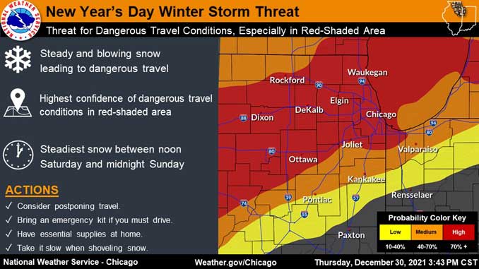
Winter Storm Watch URGENT – WINTER WEATHER MESSAGE NWS Chicago IL 247 PM CST Thu Dec 30 2021
ILZ006-013-103>105-310500- /O.NEW.KLOT.WS.A.0005.220101T1500Z-220102T1200Z/ Lake IL-DuPage-Northern Cook-Central Cook-Southern Cook- Including the cities of Waukegan, Buffalo Grove, Mundelein, Gurnee, Naperville, Wheaton, Downers Grove, Lombard, Carol Stream, Evanston, Des Plaines, Schaumburg, Palatine, Northbrook, Chicago, Cicero, Oak Lawn, Oak Park, La Grange, Calumet City, Oak Forest, Lemont, Orland Park, and Park Forest 247 PM CST Thu Dec 30 2021
…WINTER STORM WATCH IN EFFECT FROM SATURDAY MORNING THROUGH LATE SATURDAY NIGHT…
* WHAT…Steady, blowing snow and dangerous travel possible. Total snow accumulations greater than 6 inches and northeasterly wind gusts in excess of 40 mph are possible.
* WHERE…Lake IL, DuPage, Northern Cook, Central Cook and Southern Cook Counties.
* WHEN…From Saturday morning through late Saturday night.
* IMPACTS…Travel could be very difficult. Widespread blowing snow could significantly reduce visibility, especially along the Lake Michigan shoreline.
* ADDITIONAL DETAILS…The steadiest snow rates appear most likely between noon Saturday and midnight Sunday.
PRECAUTIONARY/PREPAREDNESS ACTIONS…
Monitor the latest forecasts for updates on this situation.
A chance for patchy fog exists tonight into Friday morning across the area, otherwise a dry and mild end to 2021. A potent winter storm will move through on Sat leaving cold temperatures in its wake with sub-zero wind chills Sun PM into Mon AM. #ilwx #inwx pic.twitter.com/M0bcc6iiBF
— NWS Chicago (@NWSChicago) December 30, 2021
O’HARE FORECAST …
Tonight: Patchy drizzle before 11pm. Mostly cloudy, with a low around 31. South wind around 5 mph becoming west southwest after midnight. Winds could gust as high as 15 mph.
Friday: Mostly cloudy, with a high near 43. Southwest wind around 5 mph becoming east southeast in the afternoon. Winds could gust as high as 15 mph.
Friday Night: A slight chance of drizzle before 3am, then a slight chance of drizzle and snow. Cloudy, with a low around 31. South southeast wind 5 to 15 mph becoming north northwest in the evening. Chance of precipitation is 20%.
New Year’s Day: Snow. The snow could be heavy at times. Patchy blowing snow after 1pm. High near 34. Breezy, with a north wind 15 to 20 mph, with gusts as high as 30 mph. Chance of precipitation is 100%.
Saturday Night: Snow. The snow could be heavy at times. Patchy blowing snow before midnight. Low around 15. Blustery. Chance of precipitation is 100%.
Sunday: Mostly sunny, with a high near 19.
Sunday Night: Mostly clear, with a low around 2.
Monday: Sunny, with a high near 26.
Monday Night: Partly cloudy, with a low around 20.
Tuesday: Partly sunny, with a high near 35.
Tuesday Night: Mostly cloudy, with a low around 22.
Wednesday: A chance of snow. Mostly cloudy, with a high near 31.
Wednesday Night: A chance of snow. Mostly cloudy, with a low around 16.
Thursday: A chance of snow. Mostly cloudy, with a high near 24.
LAKE TEMPS …
SOUTHERN LAKE MICHIGAN WATER TEMPERATURES
NATIONAL WEATHER SERVICE CHICAGO/ROMEOVILLE IL
901 AM CST Thu Dec 30 2021
LAKE MICHIGAN WATER TEMPERATURES…
CHICAGO SHORE……….44.
CHICAGO CRIB……….40.
MICHIGAN CITY……….42.
&&
M IS FOR MISSING DATA THAT IS NORMALLY AVAILABLE.
THE MICHIGAN CITY WATER TEMPERATURE SENSOR IS LOCATED AT A WATER
INTAKE ONE MILE OFFSHORE AND 60 FEET BELOW WATER SURFACE. IT IS READ
EVERY DAY OF THE YEAR.
december.chicagoweatherstation.com
Chicago Weather Forecast for your MAC/PC/TABLET includes surrounding suburbs.
^^ MOBILE? USE VOICE MIC ^^
facebook …
Please ‘LIKE’ the ‘Arlington Cardinal Page. See all of The Cardinal Facebook fan pages at Arlingtoncardinal.com/about/facebook …
Help fund The Cardinal Arlingtoncardinal.com/sponsor
20240105-1435future
