
NWS FORECAST: KORD | KPWK | Forecast Graph O’Hare
***********
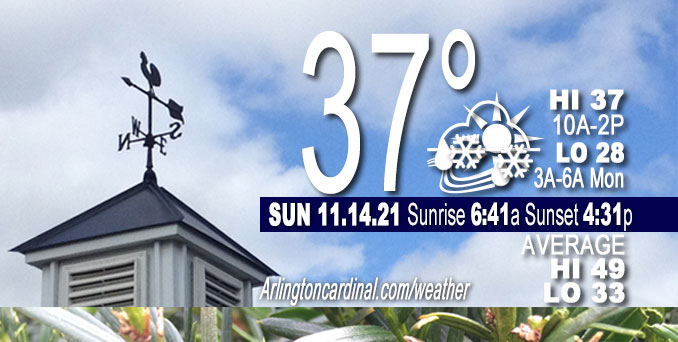
O’HARE FORECAST …
Today: Rain and snow showers likely, mainly before 1pm. Cloudy, with a high near 38. Breezy, with a southwest wind 15 to 20 mph becoming northwest in the afternoon. Winds could gust as high as 35 mph. Chance of precipitation is 60%. Total daytime snow accumulation of less than a half inch possible.
Tonight: Mostly cloudy, then gradually becoming mostly clear, with a low around 28. Northwest wind 10 to 15 mph decreasing to 5 to 10 mph after midnight. Winds could gust as high as 35 mph.
Monday: A slight chance of snow between 9am and 10am, then a chance of rain and snow. Mostly cloudy, with a high near 37. West wind 5 to 10 mph becoming south in the afternoon. Chance of precipitation is 30%.
Monday Night: Mostly cloudy, with a low around 33. South wind around 5 mph, with gusts as high as 10 mph.
Key messages from NWS Chicago in the short term period:
* Quick moving clipper system impacting the area today and tonight
* Gusty rain/snow showers mid-morning through early afternoon (only minor slushy accumulations)
* Wind gusts 30-40 mph, with occasional higher gusts to 45 mph possible. Highest gusts southwest of Chicago metro and into Porter County, IN
* Lingering lake effect rain/snow showers into Porter County this evening (accumulations forecast under 2″) * Building waves along the NW Indiana shore will result in minor lakeshore flooding into Porter County
A quick moving Alberta Clipper low pressure system continues to impact the area early this morning with the center of the low still located in central Wisconsin. An initial band of light snow has since exited the area earlier this morning. Another axis of warm-advective precipitation has struggled to fully saturate over much of our area, with the exception being along the I-55 corridor south of I-80 and further north over Lake Michigan. Hi-res guidance continues to try to fill this in as this axis shifts further east. NWS Chicago has trended lower with precipitation chances through the start of the morning for areas north of I-80, with precipitation chances increasing with eastward extent through the next few hours into northwest Indiana. Expect sudden reductions in visibility under the heavier rain/snow showers along with gusty winds and only minor slushy accumulations on grassy/elevated surfaces.
With little cloud ice in between this “arc” of precipitation and the area closer to the surface low center, would expect mostly dry conditions, perhaps with some drizzle/flurries at times. Expect the coverage of rain/snow showers to increase by late morning, however, and into the early afternoon hours across far northeast Illinois. This activity will become confined to areas near the lake by late afternoon, with lake effect rain/snow showers persisting into northwest Indiana into the evening, especially Porter county and points eastward. There remains some variability in snow totals among the various models, with hi-res guidance being the most bullish. Have trended on the lower side with totals under 2 inches for east central Porter county.
Winds today will also be quite strong, and borderline wind advisory criteria (45 mph) on the back side of this low pressure. The highest winds will be focused in areas mainly southwest of the Chicago metro as well as into northwest Indiana thanks to strong northwest winds off of the lake. For now will issue a SPS to message the stronger winds and mention brief wind advisory gusts are possible. The strong winds that develop over Lake Michigan behind the front will also result in building waves across southern Lake Michigan, especially into Porter county, Indiana where a Lakeshore Flood Advisory has been issued for this afternoon through tonight.
Once this system exits the area, we could see some clearing across northern Illinois (lake effect clouds will persist into Indiana). However, clouds will be on the increase by Monday morning as another quick hitting axis of warm advective light rain/snow moves through on Monday, noted well in isentropic plots, especially the 290K surface. While it may take some time for the full column to saturate, suspect we will have at least some light precipitation by late morning early afternoon. Currently not expecting major impacts with this but it will keep high temperatures a bit cooler on Monday in the mid-to-upper 30s for most areas.
DEW/FROST/SNOW
Scattered light snow, no accumulation.
Weather Radar shows light precipitation moving east in northeast Illinois and a heavier band of precipitation moving east from Michigan to northwest Indiana to east-central Illinois at 6:45 a.m.
Arlingtoncardinal.com/clouds | Arlingtoncardinal.com/temps
**********
WEATHER OBSERVATIONS
NWS CHICAGO
TRAFFIC
Chicagoland Traffic on Twitter
Northwest Suburbs
Google Traffic Layer | waze map
Arlington Heights North
Google Traffic Layer | waze map
Arlington Heights South
Google Traffic Layer | waze map
Chicagoland
Google Traffic Layer | waze map
Cook County
Google Traffic Layer | waze map
Lake County
Google Traffic Layer | waze map
McHenry County
Google Traffic Layer | waze map
DuPage County
Google Traffic Layer | waze map
Kane County
Google Traffic Layer | waze map
Will County
Google Traffic Layer | waze map
Flights
flightradar24 DIRECT …
O’Hare | Midway | Chicago Executive | DuPage
^^ MOBILE? USE VOICE MIC ^^
facebook …
Please ‘LIKE’ the ‘Arlington Cardinal Page. See all of The Cardinal Facebook fan pages at Arlingtoncardinal.com/about/facebook …
Help fund The Cardinal Arlingtoncardinal.com/sponsor
20240105-1435future
CBS THIS MORNING …
Latest videos from CBSThisMorning.
Youtube.com/CBSThisMorning/videos
TODAY NBC …
Latest videos from TODAYNBC.
GMA …
Latest video from GMA.
Second to latest video from GMA.
Much of the information in this article consists of material from the National Weather Service, which is in the public domain. As required by 17 U.S.C. § 403, third parties producing copyrighted works consisting predominantly of the material appearing in NWS Web pages must provide notice with such work(s) identifying the NWS material incorporated and stating that such material is not subject to copyright protection.
