
NWS FORECAST: KORD | KPWK | Forecast Graph O’Hare
***********
O’HARE FORECAST …
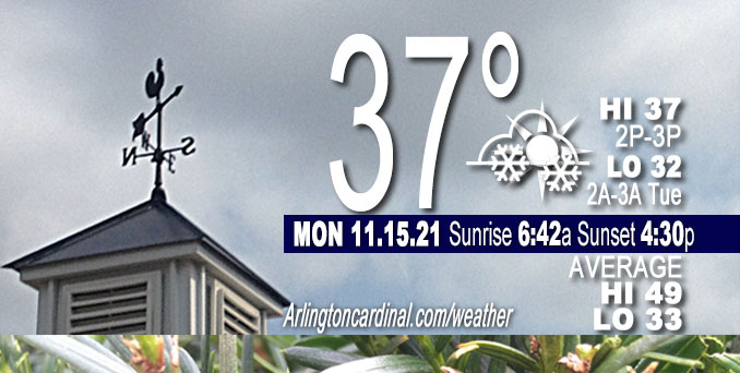
Today: A 50 percent chance of snow, mainly after 2pm. Cloudy, with a high near 37. West wind around 5 mph becoming south southeast in the afternoon. Winds could gust as high as 10 mph.
Tonight: A 20 percent chance of snow before 8pm. Mostly cloudy, with a low around 32. Southeast wind around 5 mph.
Tuesday: Partly sunny, with a high near 53. Southeast wind 5 to 15 mph, with gusts as high as 20 mph.
Tuesday Night: Mostly cloudy, with a low around 48. South southeast wind 10 to 15 mph becoming southwest after midnight. Winds could gust as high as 25 mph.
Main forecast concern in the near term on Monday, November 15, 2021 is the potential for a period of light snow across parts of the area today. Some questions remain with the degree of deep saturation which will result, in association with transient frontogenetic forcing associated with a mid-level speed max transiting a northwest- southeast oriented baroclinic zone across the region. The thermal column is sub-freezing (except perhaps right at the surface later today as surface temps warm above freezing), so provided dee Penough saturation develops for precipitation to reach the surface the primary p-type should be snow.
Stepping back and looking at the big picture early this morning, GOES water vapor imagery depicts a long-wave upper trough across eastern North America with broad upper ridging over the western part of the continent. Fast northwest flow aloft was in place from the Northern Plains to the Midwest, while at the surface a northwest to southeast oriented warm front was taking shape from elongated surface low pressure over the western Dakotas southeast into the lower Missouri River valley. A mid/upper level jet streak was noted propagating southeast along the elevated baroclinic zone northwest of the forecast area, helping to induce an area of mid-level frontogenesis from western Minnesota into eastern Iowa.
Regional radar mosaic depicts returns in this area as of 2:30 am, though surface observations indicate cloud bases generally above 6-8 kft and no reports of precipitation at the surface just yet. Guidance continues to indicate this forcing and associated saturation will develop southeast into our area later this morning, and high-res models have focused the greatest potential for a northwest to southeast axis of precipitation across the NWS Chicago County Warning Area especially from mid-morning into this afternoon. Forecast soundings from various models suggest top-down saturation will take some time before allowing precipitation to reach the surface, and models do indicate some weakening/loss of focus to the stronger f-gen this afternoon making precipitation coverage and amounts of somewhat low confidence. Entire sounding should be below freezing except right at ground level, so expected precipitation type would be mainly snow. Based on this, the NWS Chicago has lowered probability of precipitation and minor light snow accumulations a bit from previous forecast, but overall still anticipating a period of light snow with some potential to produce some minor accumulation.
Speed max and the associated sheared mid-level vort axis slides off quickly to the east-southeast of the area this evening, with any lingering light snow south/southeast of Chicago ending. Well to our northwest, deep surface low pressure is expected to develop into the lee of the Canadian Rockies tonight as a strong upper trough moves ashore. Height falls associated with this feature eventually develops broad south-southwesterly flow across the Plains and Midwest into Tuesday, allowing a northward shift of the aforementioned warm front into the forecast area. Thus while it looks like clouds will be prevalent tonight into Tuesday, milder temps are in store. Highs on Tuesday look to range from the lower 50s near the IL/WI border, to the upper 50s/near 60 south as the front lifts north.
NWS Chicago with edits by CARDINAL NEWS
DEW/FROST
Grass is dry. Only slight frost on vehicle metal. Dew point depression 10 to 12°F overnight with mostly cloudy skies and light winds after 1:00 a.m.
Weather Radar shows light precipitation band as rain from Rockford to Peoria, Decatur and Danville, moving southeast. The band shows snow only at a small portion just north of Rockford.
Arlingtoncardinal.com/clouds | Arlingtoncardinal.com/temps
**********
WEATHER OBSERVATIONS
NWS CHICAGO
TRAFFIC
Chicagoland Traffic on Twitter
Northwest Suburbs
Google Traffic Layer | waze map
Arlington Heights North
Google Traffic Layer | waze map
Arlington Heights South
Google Traffic Layer | waze map
Chicagoland
Google Traffic Layer | waze map
Cook County
Google Traffic Layer | waze map
Lake County
Google Traffic Layer | waze map
McHenry County
Google Traffic Layer | waze map
DuPage County
Google Traffic Layer | waze map
Kane County
Google Traffic Layer | waze map
Will County
Google Traffic Layer | waze map
Flights
flightradar24 DIRECT …
O’Hare | Midway | Chicago Executive | DuPage
^^ MOBILE? USE VOICE MIC ^^
facebook …
Please ‘LIKE’ the ‘Arlington Cardinal Page. See all of The Cardinal Facebook fan pages at Arlingtoncardinal.com/about/facebook …
Help fund The Cardinal Arlingtoncardinal.com/sponsor
20240105-1435future
CBS THIS MORNING …
Latest videos from CBSThisMorning.
Youtube.com/CBSThisMorning/videos
TODAY NBC …
Latest videos from TODAYNBC.
GMA …
Latest video from GMA.
Second to latest video from GMA.
Much of the information in this article consists of material from the National Weather Service, which is in the public domain. As required by 17 U.S.C. § 403, third parties producing copyrighted works consisting predominantly of the material appearing in NWS Web pages must provide notice with such work(s) identifying the NWS material incorporated and stating that such material is not subject to copyright protection.
