
DENSE FOG ADVISORY IN EFFECT UNTIL 9 AM CDT THIS MORNING… with visibility of a quarter mile or less in spots in dense fog portions of north central and northeast Illinois.
The Dense Fog Advisory is in effect until 9:00 AM CDT this morning for the following areas …
The Dense Fog Advisory covered the following counties: Winnebago, Boone, McHenry, Lake IL, Ogle, Lee, De Kalb, Kane, DuPage, Kendall, Northern Cook, Northern Will counties.
The Dense Fog Advisory covered the following municipalities (among others): Arlington Heights, Rockford, Belvidere, Crystal Lake, Algonquin, McHenry, Woodstock, Waukegan, Buffalo Grove, Mundelein, Gurnee, Rochelle, Oregon, Byron, Dixon, DeKalb, Sycamore, Aurora, Elgin, Naperville, Wheaton, Downers Grove, Lombard, Carol Stream, Oswego, Yorkville, Plano, Evanston, Des Plaines, Schaumburg, Palatine, Northbrook, Joliet, Bolingbrook, Plainfield, and Mokena.
* IMPACTS… Hazardous driving conditions due to low visibility. If driving, slow down, use your headlights, and leave plenty of distance ahead of you.
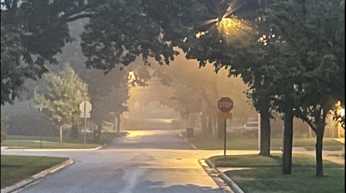
Fog with 1/2 and 1/4-mile visibility has occurred or was underway at 6:30 a.m. Friday, October 8, 2021 in much of Chicagoland. In parts of south Chicagoland, the NWS Chicago office said early this morning that it looks like cloud cover will hold until daybreak and mitigate the widespread dense fog potential in south Chicagoland, although patchy fog and perhaps some isolated spots of dense fog could still occur in parts of Chicagoland through mid-morning. A Dense Fog Advisory was issued for several communities.
Ironically cloud cover is not associated with dense fog. Clouds prevent heat radiation at the surface from being released to the upper atmosphere. Heat release to the upper atmosphere without cloud cover promotes air cooling that condenses moisture and produces dense fog. Sort of the opposite what you might expect, if you would think that clouds and fog would be connected. The present cloud cover is at least one reason the NWS Chicago office hesitated to issue a Dense Fog Advisory for parts of Cook County.
Simply put, the northwest panhandle of Cook County across to Lake Michigan was under a Dense Fog Advisory, but the rest of Cook County was not.
Dew point depression (T-Td) is the difference between the temperature and dew point temperature at a certain height in the atmosphere.
Dense Fog Advisory
For example, Arlington Heights, Buffalo Grove, Cary, Darien, Elk Grove Village, Evanston, Frankfort, Joliet, Lake Forest, Libertyville, Lockport, Long Grove, McHenry, Naperville, Rolling Meadows, Schaumburg, and Wheaton were under a Dense Fog Advisory this morning.
No Dense Fog Advisory
Chicago Heights, Manteno, Maywood, Morris, Norridge, Orland Park, Rogers Park neighborhood in Chicago, Tinley Park, and Soldier Field were not under a Dense Fog Advisory.
There was no Dense Fog Advisory for O’Hare International Airport, but just across York Road and Elmhurst Road, there was a Dense Fog Advisory in Elk Grove Village.
Airport Dew Point Depressions
At Waukegan Regional Airport at 6:55 a.m. Air Temperature was 61°F and Dew Point was 60°F
At Chicago Executive Airport at 5:52 a.m. Air Temperature was 60°F and Dew Point was 60°F
At DuPage Airport at 6:52 a.m. Air Temperature was 61°F and Dew Point was 60°F
At Midway International Airport at 6:52 a.m. Air Temperature was 64°F and Dew Point was 60°F
At O’Hare International Airport at 6:51 a.m. Air Temperature was 62°F and Dew Point was 61°F
According to the NWS Chicago, with mostly calm winds and dew point depressions currently and expected to remain 3 degrees or less pretty much across the entirety of the forecast area through the pre-dawn hours, the locally dense fog will still likely persist in some spots across Chicagoland through the early/mid-morning. However, the overhead cloud cover is not expected to erode enough to the point where widespread air cooling and dense fog would become a concern in our area. Hence, a Dense Fog Advisory issuance did not initially appear to be warranted.
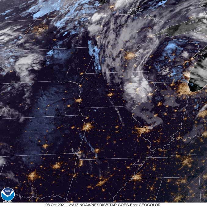
Weather Radar in northeast Illinois is clear, but storm exist over Lake Michigan.
See also Arlingtoncardinal.com/clouds
Areas of fog, which will be locally dense in some locations, will persist through the mid-morning hours. If you are driving this morning, be prepared for rapid reductions in visibility and use caution if driving through fog. #ilwx #inwx pic.twitter.com/lNwtA7LRFo
— NWS Chicago (@NWSChicago) October 8, 2021
One more period of scattered showers & storms is expected today, mainly during the afternoon, before drier weather prevails over the weekend. Above normal temperatures will continue through the weekend and into the start of the next work week. #ilwx #inwx pic.twitter.com/AB2QSRJBCo
— NWS Chicago (@NWSChicago) October 8, 2021
A very foggy commute this morning, Lake County. Drive carefully, allow some extra time, and arrive safely. pic.twitter.com/mhIeIXnV1q
— Lake County Sheriff (@LakeCoILSheriff) October 8, 2021
Crazy dense fog at Butler Park in libertyville, Il @NWSChicago #ilwx pic.twitter.com/L47BwFMaYu
— Joshua Kelton (@NILStormSpotter) October 8, 2021
O’HARE FORECAST …
Today: A chance of showers and thunderstorms, then showers likely and possibly a thunderstorm after 4pm. Patchy fog before 10am. Otherwise, mostly cloudy, with a high near 72. Calm wind becoming south southwest around 5 mph in the afternoon. Chance of precipitation is 60%. New rainfall amounts between a tenth and quarter of an inch, except higher amounts possible in thunderstorms.
Tonight: A chance of showers and thunderstorms before 7pm, then a slight chance of showers between 7pm and 9pm. Mostly cloudy, with a low around 61. Southwest wind around 5 mph. Chance of precipitation is 30%.
Saturday: Mostly sunny, with a high near 79. Light south southwest wind becoming south southeast 5 to 10 mph in the morning.
Saturday Night: Mostly cloudy, with a low around 67. Southeast wind 10 to 15 mph.
Sunday: Partly sunny, with a high near 85. South wind around 15 mph, with gusts as high as 30 mph.
Sunday Night: A 20 percent chance of showers after 1am. Mostly cloudy, with a low around 67.
Columbus Day: A chance of showers, then showers likely and possibly a thunderstorm after 1pm. Mostly cloudy, with a high near 80. Chance of precipitation is 70%.
Monday Night: Showers likely and possibly a thunderstorm before 1am, then a slight chance of showers. Mostly cloudy, with a low around 61.
Tuesday: Partly sunny, with a high near 73.
Tuesday Night: Partly cloudy, with a low around 58.
Wednesday: A chance of showers. Partly sunny, with a high near 76.
Wednesday Night: A chance of showers. Mostly cloudy, with a low around 60.
Thursday: A chance of showers. Partly sunny, with a high near 73.
LAKE TEMPS …
SOUTHERN LAKE MICHIGAN WATER TEMPERATURES
NATIONAL WEATHER SERVICE CHICAGO/ROMEOVILLE IL
917 AM CDT Thu Oct 7 2021
LAKE MICHIGAN WATER TEMPERATURES…
CHICAGO SHORE……….66.
CHICAGO CRIB……….63.
CHICAGO BUOY……….66.
WILMETTE BUOY……….66.
WAUKEGAN BUOY……….M.
WINTHROP HARBOR BUOY……….65.
MICHIGAN CITY……….66.
MICHIGAN CITY BUOY………M.
SOUTH MID LAKE BUOY……….66.
NORTH MID LAKE BUOY……….64.
&&
M IS FOR MISSING DATA THAT IS NORMALLY AVAILABLE.
THE MICHIGAN CITY WATER TEMPERATURE SENSOR IS LOCATED AT A WATER
INTAKE ONE MILE OFFSHORE AND 60 FEET BELOW WATER SURFACE. IT IS READ
EVERY DAY OF THE YEAR.
october.chicagoweatherstation.com
Chicago Weather Forecast for your MAC/PC/TABLET includes surrounding suburbs.
^^ MOBILE? USE VOICE MIC ^^
facebook …
Please ‘LIKE’ the ‘Arlington Cardinal Page. See all of The Cardinal Facebook fan pages at Arlingtoncardinal.com/about/facebook …
Help fund The Cardinal Arlingtoncardinal.com/sponsor
20240105-1435future
