

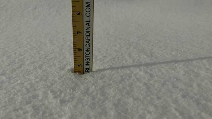
Arlington Heights Snow Accumulation 4.5 inches Tuesday Morning at 7:00 AM
Total snow accumulation for the Winter Storm January 25-26, 2021 is now forecast to be about 3 inches less (7.5 inches) than last night’s forecast of 10.5 inches. The actual total snowfall for noon Wednesday may also fall short of 7.5 inches. Snowfall intensities are trending downward, and the downward trend is expected to continue Tuesday through Wednesday.
The Winter Storm Warning for Arlington Heights and nearby communities continues to be in effect until 5:00 p.m. January 26, 2021, but may be canceled early.
Southern Cook, La Salle, Kendall, Grundy, and Western Will counties have already been converted by the National Weather Service Chicago to Winter Weather Advisories for today. In Arlington Heights, moderate to heavy snow bands are forecast to continue until 9:00 a.m. to noon, but may convert to light snow sooner.
Accumulating snowfall last night began about two to three hours later than expected, and the snow was not as wet and heavy as expected. Snow Water Ratio was probably closer to 12:1 or 15:1 instead of the 10:1 that was forecast. Snow packing for snowballs is actually not that good.
Winter Storm total Accumulations Tuesday Morning in Arlington Heighgts
3.5 inches of snow accumulated by 3:00 a.m.
4.0 inches of snow accumulated by 4:20 a.m.
4.5 inches of snow accumulated by 7:00 a.m.
There was a 6.0 inch report from Palatine at 4:30 a.m.
6.5 inches are forecast by 6:00 p.m. Tuesday, but snow is likely to fall short of that forecast.
7.5 inches are forecast by noon Wednesday, but snow is likely to fall short of that forecast.
Weather Radar) showed precipitation over most of northern Illinois at 4:00 a.m. Many areas nearby showed spotty precipitation with heavy areas right next to relatively empty radar spots. At 7:15 a.m. the precipitation had contracted from areas south of I-80 to areas around I-88.
[1:00 AM 1/26/2021] Moderate to heavy snow continues north of I-80, with freezing drizzle to the south. Road conditions continue to deteriorate. If you must travel, use extra caution, and give those snow clearing crews extra space! #ILwx #INwx pic.twitter.com/SVXCYPLIUg
— NWS Chicago (@NWSChicago) January 26, 2021
Late Eve Winter Storm Update: Lowered forecast storm total snowfall a bit (only locally 6"+ inland) & up to 5-8" near Lake MI in N IL. Freezing rain & drizzle south of I-80, possibly into early-mid Tue AM. Hazardous travel tonight into Tue AM-Avoid unnecessary travel! #ilwx #inwx pic.twitter.com/EvqCQosy8O
— NWS Chicago (@NWSChicago) January 26, 2021
O’HARE FORECAST …
Winter Storm Warning
Lakeshore Flood Advisory
Today: Snow. Patchy blowing snow before 9am. High near 31. North northeast wind 10 to 15 mph, with gusts as high as 30 mph. Chance of precipitation is 100%. Total daytime snow accumulation of 1 to 3 inches possible.
Tonight: A 50 percent chance of snow. Cloudy, with a low around 23. North wind around 10 mph, with gusts as high as 20 mph.
Wednesday: Snow showers likely, mainly before noon. Mostly cloudy, with a high near 25. North wind 10 to 15 mph. Chance of precipitation is 60%. New snow accumulation of less than a half inch possible.
Wednesday Night: Mostly clear, with a low around 9. Wind chill values as low as -1. North northwest wind 5 to 10 mph, with gusts as high as 15 mph.
Thursday: Mostly sunny, with a high near 25. Northwest wind around 5 mph.
Thursday Night: Partly cloudy, with a low around 11.
Friday: Partly sunny, with a high near 30.
Friday Night: Mostly cloudy, with a low around 23.
Saturday: A chance of snow after noon. Cloudy, with a high near 34.
Saturday Night: Snow likely. Cloudy, with a low around 29.
Sunday: A chance of snow. Cloudy, with a high near 36.
Sunday Night: A slight chance of snow. Mostly cloudy, with a low around 26.
Monday: Mostly cloudy, with a high near 33.
LAKE TEMPS …
SOUTHERN LAKE MICHIGAN WATER TEMPERATURES
NATIONAL WEATHER SERVICE CHICAGO/ROMEOVILLE IL
903 AM CST Mon Jan 25 2021
LAKE MICHIGAN WATER TEMPERATURES…
CHICAGO SHORE……….38.
CHICAGO CRIB……….36.
MICHIGAN CITY……….34.
&&
M IS FOR MISSING DATA THAT IS NORMALLY AVAILABLE.
THE MICHIGAN CITY WATER TEMPERATURE SENSOR IS LOCATED AT A WATER INTAKE ONE MILE OFFSHORE AND 60 FEET BELOW WATER SURFACE. IT IS READ EVERY DAY OF THE YEAR.
january.chicagoweatherstation.com
Chicago Weather Forecast for your MAC/PC/TABLET includes surrounding suburbs.
^^ MOBILE? USE VOICE MIC ^^
facebook …
Please ‘LIKE’ the ‘Arlington Cardinal Page. See all of The Cardinal Facebook fan pages at Arlingtoncardinal.com/about/facebook …
Help fund The Cardinal Arlingtoncardinal.com/sponsor
20240105-1435future
