
")
Arlington Heights and Chicago Northwest Suburbs Forecast
Peak winds over 40 MPH are likely between 1:00 p.m. and 10:00 p.m. Gusts will continue above 25 MPH until about 4:00 a.m. Wednesday. An approaching surface low, a strong mid-level trough (elongated area of relatively low atmospheric pressure), and a strong upper level jet are connected to this forecast activating a Wind Advisory.
The peak chance for severe thunderstorms with high winds is 5:00 p.m. to 8:00 p.m. Tuesday (today). NOAA Storm Prediction Center posted a Tornado Outlook with a Tornado Risk of 5% for much of northern Illinois and west-central Illinois. Less than 0.5 inch of rain is forecast. A high of 74°F is forecast from noon to 4:00 p.m. Tuesday, November 10, 2020 with today marking the end of a mild period of record warmth for early November 2020. Enjoy the strong southerly flow of mild, humid air until thunderstorms begin to develop in our area as early as 4:00 p.m.
Weather Radar) shows very small pop-up precipitation areas over northern Illinois.
Before the windy, active weather change comes later Tuesday, let's enjoy these numbers for Chicago:
10 p.m. Nov 9th temperature: 70°
Normal Nov 9th HIGH: 52°#ILwx https://t.co/mDhzzw4lWo
— NWS Chicago (@NWSChicago) November 10, 2020
WIND ADVISORY
WIND ADVISORY IN EFFECT FROM NOON TODAY TO 10 PM CST THIS
EVENING…* WHAT…South to southwest winds 20 to 30 mph with gusts up to 45
mph expected. Occasional gusts up to 50 mph or more possible.* WHERE…Portions of northwest Indiana and central, east
central, north central and northeast Illinois.* WHEN…From noon today to 10 PM CST this evening. The strongest
winds are expected from about 3 PM to 9 PM.* IMPACTS…Gusty winds could blow around unsecured objects,
including tents and holiday decorations. Tree limbs could be
blown down and a few power outages may result. Travel will be
hazardous for high profile vehicles, especially on west to east
roads.* ADDITIONAL DETAILS…Fast moving showers and thunderstorms in
the late afternoon and early evening could produce brief gusts
in excess of 50 mph.PRECAUTIONARY/PREPAREDNESS ACTIONS…
Use extra caution when driving, especially if operating a high
profile vehicle. Secure outdoor objects.
Thunderstorms capable of producing isolated strong to locally damaging winds and perhaps a few tornadoes are possible this afternoon and evening across portions of the Middle Mississippi
Valley vicinity.
O’HARE FORECAST …
Overnight: A slight chance of sprinkles. Mostly cloudy, with a low around 65. South southwest wind around 15 mph, with gusts as high as 25 mph.
Tuesday: A chance of showers before 4pm, then a chance of showers and thunderstorms between 4pm and 5pm, then showers likely and possibly a thunderstorm after 5pm. Mostly cloudy, with a high near 74. Breezy, with a south wind 15 to 20 mph increasing to 20 to 25 mph in the afternoon. Winds could gust as high as 45 mph. Chance of precipitation is 70%. New rainfall amounts of less than a tenth of an inch, except higher amounts possible in thunderstorms.
Tuesday Night: Showers and possibly a thunderstorm before 9pm, then a chance of showers between 9pm and 10pm. Low around 37. Breezy, with a south southwest wind 20 to 25 mph becoming west 15 to 20 mph after midnight. Winds could gust as high as 45 mph. Chance of precipitation is 100%. New precipitation amounts between a quarter and half of an inch possible.
Veterans Day: Sunny, with a high near 50. West wind 5 to 15 mph, with gusts as high as 20 mph.
Wednesday Night: Mostly clear, with a low around 35. Southwest wind around 5 mph.
Thursday: Sunny, with a high near 55.
Thursday Night: Partly cloudy, with a low around 34.
Friday: Sunny, with a high near 45.
Friday Night: Partly cloudy, with a low around 32.
Saturday: A chance of rain, mainly after noon. Mostly cloudy, with a high near 48.
Saturday Night: A chance of rain. Mostly cloudy, with a low around 43.
Sunday: A slight chance of rain. Partly sunny, with a high near 56.
Sunday Night: Partly cloudy, with a low around 38.
Monday: Mostly sunny, with a high near 47. Breezy.
LAKE TEMPS …
SOUTHERN LAKE MICHIGAN WATER TEMPERATURES
NATIONAL WEATHER SERVICE CHICAGO/ROMEOVILLE IL
916 AM CST Mon Nov 9 2020
LAKE MICHIGAN WATER TEMPERATURES…
CHICAGO SHORE……….50.
CHICAGO CRIB……….49.
MICHIGAN CITY……….50.
SOUTH MID LAKE BUOY……….48.
NORTH MID LAKE BUOY……….51.
&&
M IS FOR MISSING DATA THAT IS NORMALLY AVAILABLE.
THE MICHIGAN CITY WATER TEMPERATURE SENSOR IS LOCATED AT A WATER
INTAKE ONE MILE OFFSHORE AND 60 FEET BELOW WATER SURFACE. IT IS READ
EVERY DAY OF THE YEAR.
november.chicagoweatherstation.com
Chicago Weather Forecast for your MAC/PC/TABLET includes surrounding suburbs.
^^ MOBILE? USE VOICE MIC ^^
facebook …
Please ‘LIKE’ the ‘Arlington Cardinal Page. See all of The Cardinal Facebook fan pages at Arlingtoncardinal.com/about/facebook …
Help fund The Cardinal Arlingtoncardinal.com/sponsor
20240105-1435future
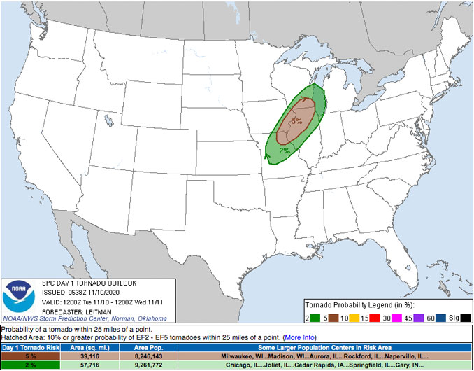
A potent midlevel shortwave trough will become negatively tilted today as it ejects east/northeast from northern/central Plains to the upper Great Lakes. At the surface, low pressure will deepen at it track northeast from MO into eastern IA by midday. Strong southerly flow ahead of the surface low and eastward-advancing cold front will transport low 60s dewpoints as far north as southern WI and southern lower MI. While heating will be limited by cloudy skies, cooling aloft will result in steepening midlevel lapse rates and modest instability (generally less than 750 J/kg MLCAPE) is expected during the afternoon and early evening. Thunderstorms are first expected to develop and intensify during the afternoon across northern MO into eastern IA. Deep layer flow will generally be parallel to the cold front, supporting a more linear storm-mode with line segments/QLCS development expected.
Given the deepening surface low, some backing of near-surface winds is expected closer to the low from eastern IA into northern IL and southern WI. This could increase the potential for mesovortex formation within the broader QLCS/bowing segments. Forecast soundings indeed show enlarged, curved hodographs with both increasing directional and speed shear leading to 0-1 km SRH values greater than 250 m2/s2. As a result, a few tornadoes are possible, in addition to isolated strong/locally damaging wind gusts. The severe threat should decrease with time and eastward extent as the boundary layer stabilizes with the loss of daytime heating and strong forcing ejects northeast over the upper Great Lakes and Ontario.
SOURCE:
Day 1 Convective Outlook
NWS Storm Prediction Center Norman OK
1138 PM CST Mon Nov 09 2020
Valid 101200Z – 111200Z
(NOV 10 6AM CT to NOV 10 6PM CT)
