

Perhaps because 2020 has been such a strange year, there needs to be an alert when conditions are predicted to be without any risks. There was some concern there might have been risky conditions for wildland or grass fires today, but this message doesn’t exactly refer to the “Red Flag” condition risk. Certainly there must be a perfectly good explanation for this odd “Weather Alert Message” on FOX 32 Chicago’s website today, Tuesday, October 13, 2020 …
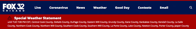
“Special Weather Statement until TUE 7:00 PM CDT
National Weather Service says there is a minimal to no known threat to life or property in Central Cook County, DeKalb County, DuPage County, Eastern Will County, Grundy County, Kane County, Kankakee County, Kendall County, La Salle County, Northern Cook County, Northern Will County, Southern Cook County, Southern Will County, La Porte County, Lake County, Newton County, Porter County, Jasper County.
This alert comes from the National Weather Service in Chicago, Illinois. It was issued at 14:12 PM on October 13, 2020 CDT. It expires at 19:00 PM on October 13, 2020 CDT.”
When viewers touched or clicked the banner above at the top of the Fox 32 Chicago website, viewers were referred to the message below …
In the context of the Hazardous Weather Outlook from the National Weather Service at 3:30 a.m. Tuesday, October 13, 2020, it’s possible that the alert was referring to risks that were expressed for today and later this week.
Breezy conditions are expected this afternoon with southwest winds gusting to 30 to 35 mph. These strong winds combined with low relative humidity levels will create elevated to near-critical fire danger during the afternoon hours.
DAYS TWO THROUGH SEVEN…Wednesday through Monday.
Wednesday…
Limited Non Thunderstorm Wind Risk.
Elevated Fire Weather Risk.
Thursday Night…
Elevated Freeze Risk
Saturday…
Limited Non Thunderstorm Wind Risk.
Elevated Fire Weather Risk.
Here is the full “Hazardous Weather Outlook” released at 3:13 a.m. this morning …
Hazardous Weather Outlook
National Weather Service Chicago/Romeoville IL
313 AM CDT Tue Oct 13 2020
ILZ003>006-008-010>013-019>021-023-032-033-039-103>108-INZ001-002-
010-011-019-140815-
Winnebago-Boone-McHenry-Lake IL-Ogle-Lee-De Kalb-Kane-DuPage-
La Salle-Kendall-Grundy-Kankakee-Livingston-Iroquois-Ford-
Northern Cook-Central Cook-Southern Cook-Northern Will-
Southern Will-Eastern Will-Lake IN-Porter-Newton-Jasper-Benton-
313 AM CDT Tue Oct 13 2020 /413 AM EDT Tue Oct 13 2020/
This Hazardous Weather Outlook is for portions of North Central
Illinois…Northeast Illinois and Northwest Indiana.
.DAY ONE…Today and Tonight.
Weather hazards expected…
Limited Non thunderstorm wind Risk.
Elevated Fire Weather Risk.
DISCUSSION…
Breezy conditions are expected this afternoon with southwest
winds gusting to 30 to 35 mph. These strong winds combined with
low relative humidity levels will create elevated to near-critical
fire danger during the afternoon hours.
.DAYS TWO THROUGH SEVEN…Wednesday through Monday.
Wednesday…
Limited Non Thunderstorm Wind Risk.
Elevated Fire Weather Risk.
Thursday Night…
Elevated Freeze Risk
Saturday…
Limited Non Thunderstorm Wind Risk.
Elevated Fire Weather Risk.
DISCUSSION:
Breezy and dry conditions are once again expected on Wednesday
which will lead to another period of elevated fire danger during
the afternoon.
Near and subfreezing temperatures will be possible Thursday night,
mainly north and west of I-55.
.SPOTTER INFORMATION STATEMENT…
Spotter activation will not be necessary through tonight.
^^ MOBILE? USE VOICE MIC ^^
facebook …
Please ‘LIKE’ the ‘Arlington Cardinal Page. See all of The Cardinal Facebook fan pages at Arlingtoncardinal.com/about/facebook …
Help fund The Cardinal Arlingtoncardinal.com/sponsor
20240105-1435future
THANKS FOR READING CARDINAL NEWS
