
Storms may continue to develop in southern Wisconsin and move into northeast Illinois, but the trend may involve a weakening of the thunderstorm cells. Some loud thunder with sporadic cloud-to-ground lightning was observed between 11:30 a.m. and 12:30 p.m. in the northwest suburbs. More severe thunderstorms crossed the area of DeKalb, Sandwich, Lake Holiday, Morris, and Channahon. A Tornado Warning was issued at 11:56 a.m. for Kendall County and La Salle County, Illinois and expired at 12:30 p.m. At 1156 AM CDT, a severe thunderstorm capable of producing a tornado was located near Somonauk, or near Sandwich, moving southeast at 45 mph. Radar indicated rotation, but the storm that prompted the warning weakened below severe limits. A Severe Thunderstorm Warning was issued further east near Joliet and Aurora.
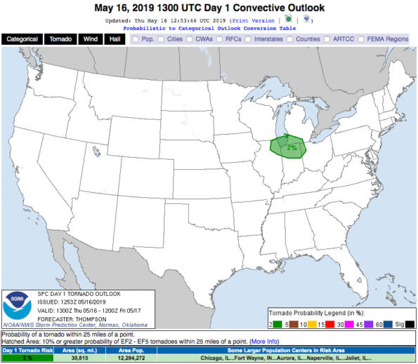
Weather Radar (also nexrad.chgowx.com) shows the trail edge of storms over Arlington Heights at 12:40 p.m., but the leading edge of storms looks severe in Will County, Kendall and Grundy counties. The radar shows a bowing echo which indicates high winds are possible in Will, Kendall and Grundy Counties … and counties south and west of those counties. The SPC Day 3 Categorical Outlook issued May 14, 2019 put our area at enhanced risk of severe thunderstorms. Today’s outlook put us in a 2% Tornado Risk.
Taken from the Snadwich High School Peking lot!! #ILwx #Tornado @NWSChicago pic.twitter.com/wPqJCxembS
— Jake Smith (@jwsmith_056) May 16, 2019
Thunderstorms are moving through northern Illinois late this morning. The strongest storms are currently across north central Illinois capable of producing half inch hail, gusts to 45 mph and frequent lightning. Precipitation is moving to the southeast at 40 mph. pic.twitter.com/2agcheuMxA
— NWS Chicago (@NWSChicago) May 16, 2019
#Rockton pic.twitter.com/Om4oGcGup6
— Rick (@RickReese1973) May 16, 2019
O’HARE FORECAST …
This Afternoon: A slight chance of showers and thunderstorms before 4pm, then a slight chance of showers and thunderstorms after 5pm. Mostly cloudy, with a high near 80. South southwest wind around 15 mph, with gusts as high as 25 mph. Chance of precipitation is 20%.
Tonight: Showers and thunderstorms likely, mainly between 9pm and midnight. Cloudy, with a low around 52. Southwest wind 5 to 15 mph becoming north northeast after midnight. Winds could gust as high as 20 mph. Chance of precipitation is 60%. New rainfall amounts between a quarter and half of an inch possible.
Friday: A chance of showers and thunderstorms, then showers and possibly a thunderstorm after 1pm. High near 53. Northeast wind around 15 mph, with gusts as high as 20 mph. Chance of precipitation is 80%. New rainfall amounts between a quarter and half of an inch possible.
Friday Night: A 40 percent chance of showers and thunderstorms, mainly before 1am. Cloudy, with a low around 48. Northeast wind 5 to 10 mph.
Saturday: A 40 percent chance of showers and thunderstorms after 1pm. Partly sunny, with a high near 80. East wind 5 to 10 mph becoming south southwest in the afternoon. Winds could gust as high as 20 mph.
Saturday Night: A 40 percent chance of showers and thunderstorms. Mostly cloudy, with a low around 57.
Sunday: A 50 percent chance of showers and thunderstorms. Mostly cloudy, with a high near 75.
Sunday Night: A chance of showers and thunderstorms before 1am. Mostly cloudy, with a low around 50.
Monday: Partly sunny, with a high near 62.
Monday Night: Mostly cloudy, with a low around 46.
Tuesday: A chance of showers and thunderstorms. Mostly cloudy, with a high near 63.
Tuesday Night: A chance of showers and thunderstorms. Mostly cloudy, with a low around 53.
Wednesday: A chance of showers and thunderstorms. Mostly cloudy, with a high near 73.
LAKE TEMPS …
SOUTHERN LAKE MICHIGAN WATER TEMPERATURES
NATIONAL WEATHER SERVICE CHICAGO/ROMEOVILLE IL
855 AM CDT Thu May 16 2019
LAKE MICHIGAN WATER TEMPERATURES…
CHICAGO SHORE……….55.
CHICAGO CRIB……….51.
WILMETTE BUOY……….M.
WAUKEGAN BUOY……….50.
WINTHROP HARBOR BUOY……….48.
MICHIGAN CITY……….49.
MICHIGAN CITY BUOY……….53.
SOUTH MID LAKE BUOY……….39.
NORTH MID LAKE BUOY……….37.
&&
M IS FOR MISSING DATA THAT IS NORMALLY AVAILABLE.
THE MICHIGAN CITY WATER TEMPERATURE SENSOR IS LOCATED AT A WATER
INTAKE ONE MILE OFFSHORE AND 60 FEET BELOW WATER SURFACE. IT IS READ EVERY DAY OF THE YEAR.
Chicago Weather Forecast for your MAC/PC/TABLET includes surrounding suburbs.
^^ MOBILE? USE VOICE MIC ^^
facebook …
GET ALERTS on Facebook.com/ArlingtonCardinal
GET ALERTS on Facebook.com/CardinalEmergencies
GET ALERTS on Facebook.com/ArlingtonHeightsCrime
Please ‘LIKE’ the ‘Arlington Cardinal Page. See all of The Cardinal Facebook fan pages at Arlingtoncardinal.com/about/facebook …
Help fund The Cardinal Arlingtoncardinal.com/sponsor
20240105-1435future
