GUSTY WINDS, TEMPERATURES FALLING SATURDAY
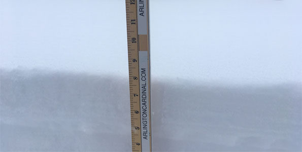
About 7.875 inches of new snow has fallen since about 1:30 p.m. Friday, January 18, 2019 at the end of the main storm’s snowfall, and prior to new Lake Effect Snow. New snow cover depth measures 11.5 inches. There is some drifting up to 16 inches or more of fresh snow. The snow is deep, but light and fluffy.
Winter Storm Snow Accumulation + Lake Effect Snow Accumulation to Equal 9.875 Inches in Arlington Heights? Maybe.
An additional 4 inches of snow is possible by Sunday at 5:00 a.m. with unreliable predictions for Lake Effect Snow amounts. Cardinal News is favoring a forecast of about an additional 1-2 inches by Sunday at 5:00 a.m. The highest upcoming snowfall rates in the next 24 hours will likely occur between 8:00 p.m. Saturday and 4:00 a.m. Sunday from Lake Effect Snow. The Low Pressure from this storm will be passing from southeast Missouri and Arkansas through southern Illinois and Tennessee with the counterclockwise spin bringing snow bands from Lake Michigan to northeast Illinois later Saturday and overnight Saturday/Sunday. The Weather Channel graphic is showing the Low Pressure Center further north than the National Weather Service.
Besides additional snowfall, annoyances and hazards in the next 24 hours will be in the form of …
1) northeast wind gusts up to 30 MPH+ causing blowing and drifting snow, and
2) falling temperatures with Saturday’s high of 25°F falling beginning about 11:00 a.m., dipping down to 17°F by midnight Saturday/Sunday, and reaching a low of 10°F by 8:00 a.m. Sunday.
Winds will be from the northeast Saturday, then from the north by 10:00 p.m. and from the north-northwest by 3:00 a.m. Sunday.
Weather Radar (also nexrad.chgowx.com) shows snow precipitation clearing from the northwest with only with the trailing edge of precipitation in a line from the Cook County, Lake County, Lake Michigan shoreline border to Peoria, Illinois at 9:11 a.m. Saturday.
Scattered lake effect snow showers are possible this afternoon, but a single band of heavier lake effect snow expected late this evening/tonight, slowly pivoting from SE WI this evening to NW IN Sun AM. Areas near Lake Michigan will see additional snow accumulations. pic.twitter.com/oihnwLzVpI
— NWS Chicago (@NWSChicago) January 19, 2019
North/Northeast winds gusting 30-35 mph expected today. This will result in blowing & drifting snow. These winds will also drive a bitterly cold air mass into the region. Wind chill values in the single digits & teens expected through much of today, dropping below zero tonight. pic.twitter.com/95ubhnIRSP
— NWS Chicago (@NWSChicago) January 19, 2019
Another round of snow could spread from the Rockies into parts of the Midwest and Northeast next week: https://t.co/zljORlpTj2 pic.twitter.com/3vZs43rGy2
— The Weather Channel (@weatherchannel) January 19, 2019
#WinterStormHarper is spreading a mess of snow, ice and wind eastward, here's what you need to know: https://t.co/eb8QwvJPcn pic.twitter.com/VPLagIit3r
— The Weather Channel (@weatherchannel) January 19, 2019
O’HARE FORECAST …
Today: Snow. Patchy blowing snow. Temperature falling to around 22 by 5pm. Blustery, with a northeast wind around 20 mph, with gusts as high as 30 mph. Chance of precipitation is 100%. Total daytime snow accumulation of 1 to 3 inches possible.
Tonight: Snow showers, mainly before 2am. Patchy blowing snow before 1am. Low around 10. Wind chill values as low as -3. Blustery, with a north wind 15 to 20 mph, with gusts as high as 30 mph. Chance of precipitation is 80%. New snow accumulation of 2 to 4 inches possible.
Sunday: A 20 percent chance of snow showers before noon. Partly sunny, with a high near 17. Wind chill values as low as -4. North northwest wind 5 to 10 mph, with gusts as high as 15 mph.
Sunday Night: A 20 percent chance of snow before midnight. Mostly cloudy, with a low around 7. Wind chill values as low as -3. North northwest wind around 5 mph becoming east southeast after midnight. Winds could gust as high as 10 mph.
M.L.King Day: Partly sunny, with a high near 17. South southeast wind 5 to 10 mph, with gusts as high as 15 mph.
Monday Night: Mostly cloudy, with a low around 14.
Tuesday: Snow before 3pm, then snow, possibly mixed with rain between 3pm and 4pm, then rain after 4pm. High near 36. Chance of precipitation is 90%.
Tuesday Night: Rain before 7pm, then rain and snow between 7pm and midnight, then a slight chance of snow after midnight. Cloudy, with a low around 22.
Wednesday: Partly sunny, with a high near 26.
Wednesday Night: Partly cloudy, with a low around 14.
LAKE TEMPS …
SOUTHERN LAKE MICHIGAN WATER TEMPERATURES
NATIONAL WEATHER SERVICE CHICAGO/ROMEOVILLE IL
903 AM CST Sat Jan 19 2019
LAKE MICHIGAN WATER TEMPERATURES…
CHICAGO SHORE……….33.
CHICAGO CRIB……….32.
MICHIGAN CITY……….35.
&&
M IS FOR MISSING DATA THAT IS NORMALLY AVAILABLE.
THE MICHIGAN CITY WATER TEMPERATURE SENSOR IS LOCATED AT A WATER INTAKE ONE MILE OFFSHORE AND 60 FEET BELOW WATER SURFACE. IT IS READ EVERY DAY OF THE YEAR.
Winter Storm Warning ending at noon Saturday. Lakeshore Flood Advisory continuing until 9 AM Sunday.
Lakeshore Flood Advisory
Lakeshore Hazard Message
National Weather Service Chicago IL
939 AM CST Sat Jan 19 2019
Lake IL-Cook-Lake IN-
…LAKESHORE FLOOD ADVISORY REMAINS IN EFFECT UNTIL 9 AM CST SUNDAY…
* LAKE SHORE FLOODING…Onshore winds of 30 to 35 mph will produce waves of 7 to 10 ft. The large waves and strong winds will drive up lake levels, which are already above average.
* TIMING…Through mid morning Sunday
* IMPACTS…Minor flooding is likely along the Illinois and Lake County Indiana shoreline, including along the Chicago lakefront bike path in the typical flood prone areas.
* SAFETY…Avoid flood prone areas along the lakeshore and stay off of structures such as piers, jetties and breakwalls.
PRECAUTIONARY/PREPAREDNESS ACTIONS…
A Lakeshore Flood Advisory indicates that onshore winds will generate flooding of low areas along the lakeshore.
january.chicagoweatherstation.com
Chicago Weather Forecast for your MAC/PC/TABLET includes surrounding suburbs.
^^ MOBILE? USE VOICE MIC ^^
facebook …
GET ALERTS on Facebook.com/ArlingtonCardinal
GET ALERTS on Facebook.com/CardinalEmergencies
GET ALERTS on Facebook.com/ArlingtonHeightsCrime
Get updates from The Cardinal ALL NEWS FEEDS on Facebook. Just ‘LIKE’ the ‘Arlington Cardinal Page (become a fan of our page). The updates cover all posts and sub-category posts from The Cardinal — Arlingtoncardinal.com. You can also limit feeds to specific categories. See all of The Cardinal Facebook fan pages at Arlingtoncardinal.com/about/facebook …
Help fund The Cardinal Arlingtoncardinal.com/sponsor
20240105-1435future
Arctic air has pushed into the Plains and Midwest and will spread toward the East Coast through Monday: https://t.co/awtbHALaaH pic.twitter.com/uOD2cqU1VN
— The Weather Channel (@weatherchannel) January 19, 2019
Late winter to early spring temperature outlook is here: below-average temperatures are expected in the East, while parts of the West will see above-average conditions: https://t.co/fYNxcfq9Tc pic.twitter.com/JlpuYhwsem
— The Weather Channel (@weatherchannel) January 18, 2019