1) SNOWFALL TOTAL FORECAST 5.5″ FROM 11PM SUNDAY TO 11PM MONDAY, 2) SNOW MAY BECOME WETTER UNTIL ABOUT NOON MONDAY, 3) TEMPERATURES START DROPPING 1PM MONDAY, 4) RECORD LOW COLD EXPECTED WEDNESDAY AND THURSDAY, AND 5) DANGEROUS WIND CHILL TUESDAY NIGHT TO THURSDAY MORNING.
Snow has fallen at a rate of about 1 inch per hour from about 2:00 a.m. to 4:00 a.m. Monday. Persistent light snow began about 11:00 p.m. Sunday. The main snow system passed Arlington Heights and the northwest suburbs by 7:25 a.m. Monday, but light snow and flurries are forecast to continue moderately about 11:00 a.m. and then lightly until 11:00 p.m. The snow is dryer than forecast — powdery and fairly easy to shovel.
Rising temperatures until noon to 1:00 p.m. (32°F) will bring wetter snowfall and possibly some freezing drizzle (no ice accumulation) until temperatures start dropping to 28°F (2PM), 24°F (5PM), 14°F (8PM), 6°F (MIDNIGHT), -1°F (8AM TUESDAY) with a high of 4° (1PM TUESDAY).
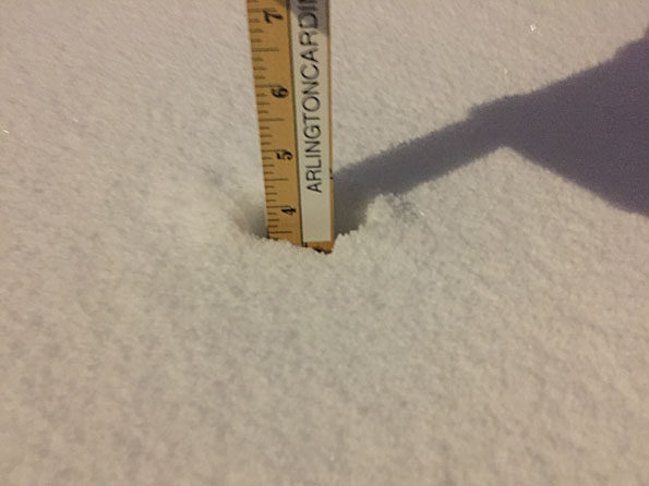
The snowfall total at 6:45 a.m. was 4 inches. Snow cover was 10.5 inches. An additional 0.5 inch of snow fell from 6:45 a.m. to 7:45 a.m. at the trailing edge of the main snow.
Dangerous wind chills of -40°F to -50°F are possible Tuesday to Wednesday overnight, Wednesday, Wednesday to Thursday overnight, and early Thursday morning.
Expect severe record cold Wednesday morning. The low forecast for Wednesday is -21°F at 8:00 am. to 9:00 a.m. If this forecast comes true, this will be a record breaker: The record low for January 30 is -15°F (1966).
The high is only forecast to reach -14°F from about 1:00 p.m. to 9:00 p.m. Wednesday. If this forecast comes true, this will be a record breaker for the day and an all-time record breaker:
1) The record low high (or record low max) for January 30 is 3°F (2004).
2) The all-time record low high (or record low max) for Chicago is -11°F (January 18, 1994).
Thursday may also break both cold records.
Thursday’s morning low forecast is -22°F. The record low for January 31 is -12°F (1985). Thursday is forecast to reach a high of 0°F about 6:00 p.m. to 7:00 p.m., dip to -2 to -3°F until about 10:00 p.m. and then being a rise in temperatures to 23°F by Friday, February 1, 2019.
The record low high (or record low max) for January 31 is 1°F.
Weather Radar (also nexrad.chgowx.com) showed the trailing edge of the significant main snowfall about 7:25 a.m.
Both Rockford and Chicago are likely to set multiple cold temperature records this week, including potentially the all time low for Rockford and the coldest daytime highs for both locations. Brutally cold wind chills also are expected Tuesday evening through Thursday morning. pic.twitter.com/bIZZ4kli7F
— NWS Chicago (@NWSChicago) January 28, 2019
Widespread heavy snow will end from west to ease this morning, but more occasional snow will be seen after that time. Significant impacts to the entire morning commute are expected for much of the area due to snow covered roads. https://t.co/hvAEYCJelM#ILwx #INwx pic.twitter.com/qz2SnUlJal
— NWS Chicago (@NWSChicago) January 28, 2019
Moderate to heavy snow & some blowing snow is occurring prior to daybreak. Even after snow intensity eases mid-morning, snow covered roads will continue since the snow fell quickly overnight & at cold temps. Be extra safe this a.m. – allow extra commute time! #ILwx #INwx pic.twitter.com/jjkmP4Fz7j
— NWS Chicago (@NWSChicago) January 28, 2019
O’HARE FORECAST …
Today: Snow, possibly mixed with freezing drizzle, becoming all snow after 2pm. Patchy blowing snow before 8am, then patchy blowing snow after 5pm. High near 32. Breezy, with a south southeast wind 10 to 15 mph becoming west northwest 15 to 20 mph in the afternoon. Winds could gust as high as 30 mph. Chance of precipitation is 100%. Little or no ice accumulation expected. Total daytime snow accumulation of 1 to 2 inches possible.
Tonight: A chance of snow before 11pm, then a chance of flurries between 11pm and midnight. Patchy blowing snow before 9pm. Cloudy, with a low around -1. Wind chill values as low as -17. Blustery, with a northwest wind 15 to 20 mph, with gusts as high as 30 mph. Chance of precipitation is 50%.
Tuesday: Partly sunny and cold, with a high near 4. Wind chill values as low as -21. West wind around 15 mph, with gusts as high as 30 mph.
Tuesday Night: Mostly cloudy, with a low around -21. Wind chill values as low as -42. West wind around 15 mph, with gusts as high as 30 mph.
Wednesday: Mostly sunny and cold, with a high near -14. West wind around 15 mph, with gusts as high as 25 mph.
Wednesday Night: Partly cloudy, with a low around -22.
Thursday: Mostly sunny and cold, with a high near 0.
Thursday Night: A chance of snow, mainly after midnight. Mostly cloudy, with a low around -3.
Friday: A slight chance of snow before noon. Mostly cloudy, with a high near 23.
Friday Night: Mostly cloudy, with a low around 18.
Saturday: Partly sunny, with a high near 38.
Saturday Night: A chance of rain and snow. Mostly cloudy, with a low around 33.
Sunday: A chance of rain and snow. Cloudy, with a high near 42.
Winter Weather Advisory
URGENT – WINTER WEATHER MESSAGE
National Weather Service Chicago IL
451 AM CST Mon Jan 28 2019
…Snow Tapering in Intensity by Mid Morning then Dangerous Cold Midweek…
Lee-DeKalb-Kane-DuPage-Cook-La Salle-Kendall-Grundy-Will-Lake IN-Porter-Including the cities of Dixon, DeKalb, Aurora, Elgin, Wheaton, Chicago, Ottawa, Oswego, Morris, Joliet, Gary, and Valparaiso
451 AM CST Mon Jan 28 2019
…WINTER WEATHER ADVISORY REMAINS IN EFFECT UNTIL 6 PM CST THIS EVENING…WIND CHILL WATCH REMAINS IN EFFECT FROM TUESDAY EVENING THROUGH THURSDAY MORNING…
* WHAT…Heavy snow through early to mid morning with lighter snow and a chance of freezing drizzle after. Patchy blowing and drifting snow through mid morning then again this afternoon. Total snow accumulations of 3 to 6 inches with highest accumulations north, and possible ice accumulations of a light glaze.
Dangerously cold wind chills as low as 50 to 55 below zero likely midweek.
* WHERE…Portions of northwest Indiana and north central and northeast Illinois.
* WHEN…For the Winter Weather Advisory, until 6 PM CST this evening, with the highest impacts likely through mid morning.
For the Wind Chill Watch, from Tuesday evening through Thursday morning.
* ADDITIONAL DETAILS…Plan on slippery road conditions. The hazardous conditions will impact the morning commute. The dangerously cold wind chills midweek could cause frostbite onexposed skin in as little as 5 minutes.
LAKE TEMPS …
SOUTHERN LAKE MICHIGAN WATER TEMPERATURES
NATIONAL WEATHER SERVICE CHICAGO/ROMEOVILLE IL
941 AM CST Sun Jan 27 2019
LAKE MICHIGAN WATER TEMPERATURES…
CHICAGO SHORE……….33.
CHICAGO CRIB……….32.
MICHIGAN CITY……….32.
&&
M IS FOR MISSING DATA THAT IS NORMALLY AVAILABLE.
THE MICHIGAN CITY WATER TEMPERATURE SENSOR IS LOCATED AT A WATER INTAKE ONE MILE OFFSHORE AND 60 FEET BELOW WATER SURFACE. IT IS READ EVERY DAY OF THE YEAR.
january.chicagoweatherstation.com
Chicago Weather Forecast for your MAC/PC/TABLET includes surrounding suburbs.
^^ MOBILE? USE VOICE MIC ^^
facebook …
GET ALERTS on Facebook.com/ArlingtonCardinal
GET ALERTS on Facebook.com/CardinalEmergencies
GET ALERTS on Facebook.com/ArlingtonHeightsCrime
Get updates from The Cardinal ALL NEWS FEEDS on Facebook. Just ‘LIKE’ the ‘Arlington Cardinal Page (become a fan of our page). The updates cover all posts and sub-category posts from The Cardinal — Arlingtoncardinal.com. You can also limit feeds to specific categories. See all of The Cardinal Facebook fan pages at Arlingtoncardinal.com/about/facebook …
Help fund The Cardinal Arlingtoncardinal.com/sponsor
20240105-1435future
Wild weather week; big snow, historic cold, rapid warm-up https://t.co/mJYsDwDEuB
— Skilling (@Skilling) January 28, 2019