Thunderstorms could develop overnight along a cold front that is in south-central Wisconsin. A moderate thunderstorm was passing Whitewater, Wisconsin and heading toward Lake Geneva, Wisconsin about 9:30 p.m. Monday. The thunderstorm weakened considerably as it approached Elkhorn, Wisconsin. There is a good shot of the storm before it dissipated as it appeared just after sunset Monday in Wisconsin (See the photo on the Chicago Weather Center blog by WGN 9 Weather).

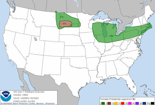
The convective outlook puts our area in a 2% tornado risk from 3:00 p.m. Monday to 7:00 a.m. Tuesday as part of a larger region as shown on the United States map.
We are in a slight increased risk for tornados. Usually some location experiences severe weather within the entire marked area for the 2% chance of tornado risk region (see map above showing marked area from Illinois to the Massachusetts).
The cold front will cool suburbs slightly near Chicago, but Algonquin, Carpentersville, Cary, Crystal Lake, Elgin, Lake Geneva (WI), Woodstock and other far northwest communities still have a Heat Advisory for Tuesday. Arlington Heights and suburbs closer to Lake Michigan, and the City of Chicago have had their Heat Advisories from the National Weather Service expire. Arlington Heights could experience a heat index of 103 on Wednesday. Today’s high was 91.9°F at 4:51 p.m. The heat index was 99°F.
Forecast for Arlington Heights as of 9:30 p.m.
Tonight: A 50 percent chance of showers and thunderstorms. Mostly cloudy, with a low around 76. West northwest wind around 5 mph.
Tuesday: A 40 percent chance of showers and thunderstorms. Partly sunny, with a high near 88. Heat index values as high as 95. Northeast wind around 5 mph.
Tuesday Night: A 20 percent chance of showers and thunderstorms. Partly cloudy, with a low around 72. East wind around 5 mph becoming south.
Wednesday: Mostly sunny, with a high near 93. Heat index values as high as 103. Southwest wind between 5 and 10 mph, with gusts as high as 15 mph.
Become a fan of The Cardinal weather page. Submit your pictures or just stay up-to-date on weather topics — go direct to the Arlington Cardinal Weather photos. For a list of all of The Cardinal Facebook fan pages, go to Arlingtoncardinal.com/about/facebook …
