
The low level jet has maximized over northeast Illinois, with occasional wind gusts to 45 mph, and a few sporadic gusts in the lower 50 mph range. Chicago O`Hare at about 9:00 p.m. Tuesday experienced a 1-minute observation at 55 mph from the south. The gusts were maximized in urban areas that are a bit warmer. Initially the Wind Advisory area was expected to be around I-80 and south of I-80.
There were some power failure problems reported around 9:20 p.m. to 9:30 p.m. in the Elk Grove Village, Bensenville area near the Thornton’s gas station at York Road and Devon Avenue. Chicago Fire Department is also responding to some power line problems. As of 3:45 a.m. the northwest suburbs near Arlington Heights have not experienced a significant amount of damage to the electric power grid infrastructure. At 3:45 a.m. the ComEd Outage map indicated no customers without power north of I-290 or north of I-88, except for the area near Thornton’s gas station, where there were nine ComEd customers expected to be restored by about 6:00 a.m. Wednesday. However, the ComEd trouble in the area near Thornton’s was cleared early at 3:53 a.m.
There have been steady temperatures of 49 to 50°F the first half of overnight period, and temperatures began to fall about 1:00 a.m., and will continue to fall all day Wednesday.
There is a Winter Storm Watch for McHenry County in effect from February 16, 03:00 AM CST until February 16, 09:00 PM CST. However, only about 2.5 to 3.0 inches of snow are forecast by the ECMWF model (European model). About 3.5 inches of snow are forecast by the GFS model (National Weather Service model). The deeper snow is forecast north of the Illinois-Wisconsin border. In McHenry, significant snow would likely begin about 6:00 a.m. Thursday, and end by 6:00 p.m. Thursday. Currently NWS Chicago is forecasting 5.7 inches from 6:00 a.m. Thursday to 11:00 p.m. Thursday.
Weather Radar showed sparse precipitation in northeast Illinois, but a larger amount of precipitation near Peoria and western Illinois was moving northeast toward Chicagoland. No snow was visible on radar in northern Illinois Tuesday night. Some lightning and thunder was indicated, but no lightning or thunder was reported. Lightning and a little thunder had been forecast around 12:00 a.m. to 1:00 a.m. There were two small areas of precipitation (rain) over Lake County and over McHenry County/Boone Counties at 3:30 a.m., but almost all of northern Illinois was clear of precipitation by 4:00 a.m. No rain is expected the rest of the day Wednesday.
Rain totaled 0.28 inch from about 5:00 p.m. Wednesday to 3:00 p.m. Thursday.
See also Arlingtoncardinal.com/clouds
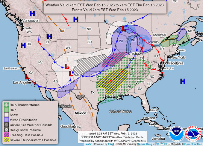
https://twitter.com/NWSChicago/status/1625642174909128705
URGENT – WEATHER MESSAGE
National Weather Service Chicago IL
952 PM CST Tue Feb 14 2023
DuPage-La Salle-Kendall-Grundy-Kankakee-Livingston-Iroquois-Ford- Northern Cook-Central Cook-Southern Cook-Northern Will- Southern Will-Eastern Will-Lake IN-Porter-Newton-Jasper-Benton- Including the cities of Naperville, Wheaton, Downers Grove, Lombard, Carol Stream, Ottawa, Streator, La Salle, Mendota, Marseilles, Oswego, Yorkville, Plano, Morris, Coal City, Minooka, Kankakee, Bourbonnais, Bradley, Pontiac, Dwight, Fairbury, Watseka, Gilman, Paxton, Gibson City, Evanston, Des Plaines, Schaumburg, Palatine, Northbrook, Chicago, Cicero, Oak Lawn, Oak Park, La Grange, Calumet City, Oak Forest, Lemont, Orland Park, Park Forest, Joliet, Bolingbrook, Plainfield, Mokena, Channahon, Manhattan, Wilmington, Crete, Peotone, Beecher, Gary, Hammond, Merrillville, Portage, Valparaiso, Chesterton, Roselawn, Kentland, Morocco, Rensselaer, DeMotte, Fowler, and Oxford 952 PM CST Tue Feb 14 2023 /1052 PM EST Tue Feb 14 2023/
…WIND ADVISORY NOW IN EFFECT UNTIL NOON CST WEDNESDAY…
* WHAT…Southwest winds 20 to 25 mph with gusts up to 50 mph.
* WHERE…Portions of central, east central, north central Illinois and northwest Indiana, and Cook and Du Page Counties of northeast Illinois.
* WHEN…Until noon CST Wednesday.
* IMPACTS…Gusty winds could blow around unsecured objects. Tree limbs could be blown down and a few power outages may result.
PRECAUTIONARY/PREPAREDNESS ACTIONS…
Use extra caution when driving, especially if operating a high profile vehicle.
Secure outdoor objects.
O’HARE FORECAST …
Tuesday Night: Showers likely and possibly a thunderstorm before 3am, then a slight chance of showers between 3am and 4am. Mostly cloudy, with a steady temperature around 49. Breezy, with a south southwest wind 15 to 20 mph, with gusts as high as 40 mph. Chance of precipitation is 70%. New rainfall amounts of less than a tenth of an inch, except higher amounts possible in thunderstorms.
Wednesday: Mostly cloudy, with a temperature falling to around 37 by 5pm. Breezy, with a west southwest wind 20 to 25 mph decreasing to 10 to 15 mph in the afternoon. Winds could gust as high as 45 mph.
Wednesday Night: Mostly cloudy, with a low around 33. West wind 5 to 15 mph becoming northeast after midnight. Winds could gust as high as 25 mph.
Thursday: Snow and freezing rain likely, possibly mixed with rain and sleet before noon, then snow. High near 33. Breezy, with a northeast wind 15 to 20 mph, with gusts as high as 35 mph. Chance of precipitation is 90%. Little or no ice accumulation expected. New snow and sleet accumulation of 2 to 4 inches possible.
Thursday Night: Snow likely before midnight. Mostly cloudy, with a low around 16. Blustery, with a north northwest wind 15 to 25 mph, with gusts as high as 35 mph. Chance of precipitation is 60%.
Friday: Sunny, with a high near 26.
Friday Night: Clear, with a low around 19. Breezy.
Saturday: Sunny, with a high near 43. Breezy.
Saturday Night: Partly cloudy, with a low around 33.
Sunday: Mostly sunny, with a high near 47.
Sunday Night: Mostly cloudy, with a low around 33.
Monday: Washington’s Birthday: Partly sunny, with a high near 43.
Monday Night: Mostly cloudy, with a low around 27.
Tuesday: A chance of snow. Partly sunny, with a high near 34.
SOUTHERN LAKE MICHIGAN WATER TEMPERATURES
NATIONAL WEATHER SERVICE CHICAGO/ROMEOVILLE IL
951 AM CST Tue Feb 14 2023
LAKE MICHIGAN WATER TEMPERATURES…
CHICAGO SHORE……….36.
CHICAGO CRIB………..35.
MICHIGAN CITY……….35.
&&
M IS FOR MISSING DATA THAT IS NORMALLY AVAILABLE.
THE MICHIGAN CITY WATER TEMPERATURE SENSOR IS LOCATED AT A WATER INTAKE ONE MILE OFFSHORE AND 60 FEET BELOW WATER SURFACE. IT IS READ EVERY DAY OF THE YEAR.
february.chicagoweatherstation.com
Chicago Weather Forecast for your MAC/PC/TABLET includes surrounding suburbs.
^^ MOBILE? USE VOICE MIC ^^
facebook …
Please ‘LIKE’ the ‘Arlington Cardinal Page. See all of The Cardinal Facebook fan pages at Arlingtoncardinal.com/about/facebook …
Help fund The Cardinal Arlingtoncardinal.com/sponsor
20240105-1435future
Area Forecast Discussion
National Weather Service Chicago/Romeoville, IL
943 PM CST Tue Feb 14 2023
.UPDATE… Issued at 931 PM CST Tue Feb 14 2023
Conditions remain mixed in the low levels this evening, more so than normally would be expected after dark. The low level jet has maximized over northeast Illinois, and thus occasional wind gusts to 45 mph, and a few sporadic gusts in the lower 50 mph range, including at Chicago O`Hare recently with a 1-minute ob at 48 kt (55 mph). These gusts have also been maximized in the urban areas that are a bit warmer.
We have correspondingly bumped up the start of the Wind Advisory for areas south of I-80 but including Cook/DuPage this evening, even though widespread wind gusts of 45-50 mph have been somewhat limited away from the metro area. This seemed prudent given the band of showers over west central IL will encounter this higher low level jet maximum and may be able to overperform what they`ve been doing upstream.
There will likely be a lull in winds after this band of showers moves through overnight. A lightning strike cannot be ruled out, but given the main instability axis skirts the area to the northwest, this would be the exception. Latest AMDAR soundings do have a bit of a warm nose at 3000 ft, but there is still 50+ kt of winds below that, so we will have to watch the 11pm – 2am window for some sporadic higher gusts from these showers.
KMD/NWS Chicago
.SHORT TERM… Issued at 1258 PM CST Tue Feb 14 2023
Through Wednesday night…
CONUS satellite imagery augmented by a recent hand surface and RA Panalyses depict a maturing surface cyclone over the Southern Plains within the left exit region of an intensifying 150 kt 250mb jet streak across the Lower Mississippi River Valley. Arcs of showers continue to expand near and ahead of the developing surface low with a broad (and intensifying) WAA regime. The first showers are now crossing northern Illinois, though the dry low-level airmass (characterized by surface T/Td spreads of 15-20 degrees) has thus far chewed up most raindrops. Continued top-down moistening via evaporation should eventually allow for raindrops to start dotting the ground this afternoon. The next band of rain is much broader and encompasses much of Iowa and Missouri, and is on track to reach our area around or just after sunset. Accordingly, we are anticipating a 2-4 hour period of showers this evening before tapering takes place from west to east by 10 PM. As the surface low matures and lifts northeastward over western Iowa this evening, the low-level pressure gradient will also tighten allowing for south to southeasterly winds to gradually intensify with gusts of 30-35 mph becoming common by sunset.
Tonight, the surface low is expected to reach peak intensity (~984 mb or so) while entering southern Minnesota as a dry slot noses into the Lower Great Lakes and an impressive 60-70kt 850-700mb LLJ slides overhead. Cooling mid-level temperatures around the periphery of the low and mid-level drying within the northeastward-spreading dry slot will steepen mid-level lapse rates and maintain the integrity of a pool of 150-250 J/kg of MUCAPE spreading northeastward from Missouri into northern Illinois. At the same time, a narrow plume of surface dew points ranging from 45-50 degrees currently in southwestern Missouri will spread northeastward, causing low-level lapse rates to improve modestly. Taken together, a band of low-topped convection originating near the MO/KS/IA borders this evening may survive and sweep across the area overnight, particularly between 04Z/10PM and 7Z/1 AM. With strong low-level wind field in place (re: LLJ) and steepening low-level lapse rates (re: low-level moisture advection), any taller convective shower may efficiently transport wind gusts of 45-50 mph toward the ground. Such a threat appears highest northwest of Interstate 55 in closer proximity to the cold core of the low and hence better MUCAPE. After touching base with SPC, we felt the probability of severe-caliber gusts was too low to warrant a formal mention in a severe weather outlook, though be aware a “pop” of winds may accompany any shower overnight.
Toward daybreak, surface winds and gusts are expected to increase markedly as mixing heights build into the base of the departing low- level wind field and surface pressures rise some 8-12mb/6 hours. BUFKIT overviews depict peak momentum transfer of 45-50kt at the to Pof the forecast mixing channel, which should support surface wind gusts of 45-50 mph across much or northern Illinois and northwestern Indiana. For this reason, we opted to expand the inherited Wind Advisory to the Wisconsin border with the expectation for the strongest winds to occur primarily between 6-10 AM CST (we padded the timing of the official product by 2-3 hours on each side). While winds will gradually decrease through the afternoon hours, it will feel much colder than the past few days as temperatures slowly fall through the 40s and eventually 30s by evening.
Borchardt/NWS Chicago
