

FLASH FLOOD WARNING 4:42 AM UNTIL 7:45 CDT SATURDAY JUNE 9 2018
Northern Cook County and far southeast Lake County has been hit the hardest overnight by thunderstorms and medium to heavy rainfall. Flash flooding, rain entering vents and leaky roofs, basement flooding, and a few power outages are the disorder overnight. Arlington Cardinal News reported a little over 3.25 inches of rain beginning after 2:00 am. Saturday, June 9, 2018. Chicago Executive Airport in Wheeling/Prospect Heights reported 2.45 inches of rain between 3:59 a.m. and 4:55 a.m. An additional 0.25 inch of rain is forecast from 5:00 a.m. to 11:00 a.m. Significant rain is expected to end by 9:00 a.m. followed by sporadic sprinkles until 11:00 a.m. A break in precipitation if forecast from 11:00 a.m. until 10:00 p.m. when scattered light rain and thundershowers are possible all day Sunday into Monday.
Weather Radar (also nexrad.chgowx.com) shows thunderstorms across most of northern Illinois north of Interstate 80.
Flash Flood Warning including Arlington Heights IL, Des Plaines IL, Mount Prospect IL until 7:45 AM CDT pic.twitter.com/E9VnREbwgu
— NWS Chicago (@NWSChicago) June 9, 2018
Showers & T-storms will continue across far northern IL. Heavy rainfall & some localized flooding from Rockford east into north Chicago burb pic.twitter.com/6aGkPLl6xa
— NWS Chicago (@NWSChicago) June 9, 2018
SPC Jun 9, 2018 0600 UTC Day 1 Convective Outlook: SPC 1200Z Day 1 Outlook Day 1 Convective Outlook NWS Storm Prediction Center Norman OK 1141 PM CDT Fri Jun 08 2018 Valid 091200Z – 101200Z …THERE IS A SLIGHT RISK OF SEVERE THUNDERSTORMS ACROSS PARTS… https://t.co/31zFNqiTrS pic.twitter.com/GJVANWaGS1
— Cardinal Weather (@CardinalWeather) June 9, 2018
O’HARE FORECAST …
As of 5:20 a.m. a Flash Flood Warning was not active at O’Hare
Overnight: Showers and thunderstorms likely. Mostly cloudy, with a low around 60. East northeast wind around 5 mph. Chance of precipitation is 60%. New rainfall amounts of less than a tenth of an inch, except higher amounts possible in thunderstorms.
Saturday: Showers and thunderstorms, mainly before 11am. High near 80. East wind around 5 mph. Chance of precipitation is 90%. New precipitation amounts between a tenth and quarter of an inch, except higher amounts possible in thunderstorms.
Saturday Night: A 40 percent chance of showers and thunderstorms after 10pm. Mostly cloudy, with a low around 66. East wind around 5 mph.
Sunday: A 40 percent chance of showers and thunderstorms. Mostly cloudy, with a high near 79. East wind 5 to 10 mph.
Sunday Night: A 30 percent chance of showers and thunderstorms. Mostly cloudy, with a low around 63. East northeast wind 5 to 10 mph.
Monday: Partly sunny, with a high near 80.
Monday Night: A 40 percent chance of showers and thunderstorms, mainly after 1am. Mostly cloudy, with a low around 67.
Tuesday: A chance of showers and thunderstorms, mainly before 1pm. Partly sunny, with a high near 82.
Tuesday Night: Partly cloudy, with a low around 60.
Wednesday: Mostly sunny, with a high near 83.
Wednesday Night: A chance of showers and thunderstorms. Partly cloudy, with a low around 63.
Thursday: A chance of showers and thunderstorms. Partly sunny, with a high near 82.
Thursday Night: Partly cloudy, with a low around 63.
Friday: A chance of showers and thunderstorms. Partly sunny, with a high near 79.
LAKE TEMPS …
SOUTHERN LAKE MICHIGAN WATER TEMPERATURES
NATIONAL WEATHER SERVICE CHICAGO/ROMEOVILLE IL
916 AM CDT Fri Jun 8 2018
LAKE MICHIGAN WATER TEMPERATURES…
CHICAGO SHORE……….65.
CHICAGO CRIB……….59.
WILMETTE BUOY……….53.
MICHIGAN CITY……….54.
MICHIGAN CITY BUOY……….63.
SOUTH MID LAKE BUOY……….53.
NORTH MID LAKE BUOY……….39.
june.chicagoweatherstation.com
Chicago Weather Forecast for your MAC/PC/TABLET includes surrounding suburbs.
^^ MOBILE? USE VOICE MIC ^^
facebook …
GET ALERTS on Facebook.com/ArlingtonCardinal
GET ALERTS on Facebook.com/CardinalEmergencies
GET ALERTS on Facebook.com/ArlingtonHeightsCrime
Get updates from The Cardinal ALL NEWS FEEDS on Facebook. Just ‘LIKE’ the ‘Arlington Cardinal Page (become a fan of our page). The updates cover all posts and sub-category posts from The Cardinal — Arlingtoncardinal.com. You can also limit feeds to specific categories. See all of The Cardinal Facebook fan pages at Arlingtoncardinal.com/about/facebook …
Help fund The Cardinal Arlingtoncardinal.com/sponsor
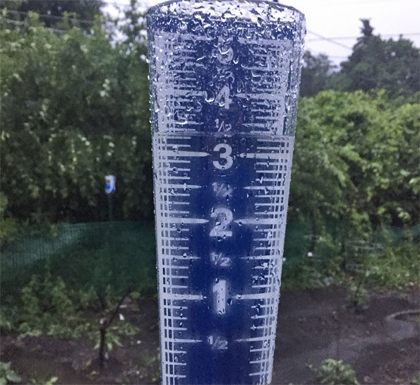 Rain overnight June 8 to June 9, 2018 in Arlington Heights.
Flash Flood Warning
Flash Flood Statement
National Weather Service Chicago/Romeoville Il
559 AM CDT SAT JUN 9 2018
ILC031-091245-
/O.CON.KLOT.FF.W.0002.000000T0000Z-180609T1245Z/
/00000.0.ER.000000T0000Z.000000T0000Z.000000T0000Z.OO/
Cook IL-
559 AM CDT SAT JUN 9 2018
…THE FLASH FLOOD WARNING REMAINS IN EFFECT UNTIL 745 AM CDT FOR
NORTH CENTRAL COOK COUNTY…
At 556 AM CDT, Doppler radar continued to indicate showers and
isolated thunderstorms across the warned area. The heaviest rainfall
has ended, but runoff and flash flooding will continue from the very
heavy rain that fell overnight. Doppler radar and rainfall
measurements suggest many areas picked up between 2 to locally over
3.5 inches of rain in just a couple hours overnight.
Law enforcement officials report flooding on many roads and some
roads are closed and impassable. Do not drive around barricades and
don`t drive into areas where water covers the roads.
Some locations that will experience flooding include…
Arlington Heights, Des Plaines, Mount Prospect, Glenview, Buffalo
Grove, Wheeling, Park Ridge, Northbrook, Wilmette, Morton Grove,
Winnetka, Glencoe, Rosemont, Niles, Prospect Heights, Northfield and
Golf.
PRECAUTIONARY/PREPAREDNESS ACTIONS…
Be especially cautious at night when it is harder to recognize the
dangers of flooding.
20240105-1435future