
Severe weather coverage in the Chicagoland Metro Area will depend on how far north a Warm Front travels today. The worst weather could make it to the Illinois-Wisconsin state line, but if the Warm Front stalls, only Chicago’s south suburbs will see severe weather.
The National Weather Service Storm Prediction Center Tornado Outlook center has placed all of Northern Illinois in a risk area or 10 percent for the probability of a tornado. The risk also includes a 10 percent or greater probability of an EF2 – EF5 tornado.
The outlook places a 10 percent risk of winds 70 mph or greater for all of Northern Illinois., and a 45 percent risk of winds 57 mph or greater in all of Northern Illinois.
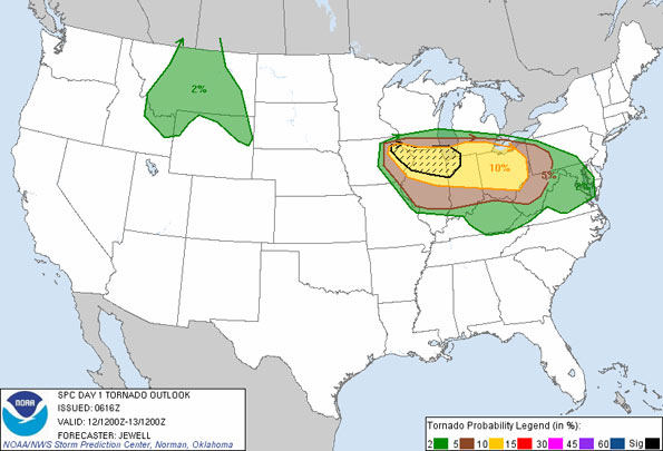
Tornado Outlook from the National Weather Service Storm Prediction Center.
FLASH FLOOD WATCH
NATIONAL WEATHER SERVICE CHICAGO/ROMEOVILLE IL
301 AM CDT WED JUN 12 2013
…HEAVY RAINFALL LIKELY OVER THE ROCKFORD AND CHICAGO METRO AREAS
LATE THIS AFTERNOON AND TONIGHT…
.THUNDERSTORMS WILL PRODUCE LOCALLY HEAVY RAINFALL WHICH COULD
RESULT IN RAPID FLOODING.
WINNEBAGO-BOONE-MCHENRY-LAKE IL-OGLE-DE KALB-KANE-DUPAGE-COOK-
KENDALL-WILL-LAKE IN-PORTER-
INCLUDING THE CITIES OF…ROCKFORD…BELVIDERE…WOODSTOCK…
WAUKEGAN…OREGON…DEKALB…AURORA…WHEATON…CHICAGO…
OSWEGO…JOLIET…GARY…VALPARAISO
301 AM CDT WED JUN 12 2013
…FLASH FLOOD WATCH IN EFFECT FROM THIS AFTERNOON THROUGH LATE
TONIGHT…
THE NATIONAL WEATHER SERVICE IN CHICAGO HAS ISSUED A
* FLASH FLOOD WATCH FOR PORTIONS OF ILLINOIS AND NORTHWEST
INDIANA…INCLUDING THE FOLLOWING AREAS…IN ILLINOIS…
BOONE…COOK…DE KALB…DUPAGE…KANE…KENDALL…LAKE IL…
MCHENRY…OGLE…WILL AND WINNEBAGO. IN NORTHWEST INDIANA…
LAKE IN AND PORTER.
* FROM THIS AFTERNOON THROUGH LATE TONIGHT.
* THUNDERSTORMS WILL PRODUCE HEAVY RAINFALL THIS AFTERNOON AND
TONIGHT. WIDESPREAD RAINFALL OF 1 TO 3 INCHES IS LIKELY NORTH OF
A LINE FROM DIXON TO GARY…WITH LOCALLY HIGHER AMOUNTS. THERE
IS THE POTENTIAL FOR VERY HIGH RAINFALL RATES IN SOME OF THE
STRONGER STORMS. THE HEAVY RAIN WILL FALL OVER HIGHLY URBANIZED
AREAS OF ROCKFORD AND CHICAGO.
* RAPID FLOODING OF CREEKS…SMALL STREAMS…ROADS…AND LOW LYING
AREAS IS POSSIBLE IN THUNDERSTORMS.
PRECAUTIONARY/PREPAREDNESS ACTIONS…
A FLASH FLOOD WATCH MEANS THAT CONDITIONS MAY DEVELOP THAT LEAD
TO FLASH FLOODING. FLASH FLOODING IS A VERY DANGEROUS SITUATION.
YOU SHOULD MONITOR LATER FORECASTS AND BE PREPARED TO TAKE ACTION
SHOULD FLASH FLOOD WARNINGS BE ISSUED.
TODAY
Showers and thunderstorms likely, mainly after 1pm. Some storms could be severe, with large hail, damaging winds, and heavy rain. Mostly cloudy, with a high near 81. East wind around 5 mph, with gusts as high as 10 mph. Chance of precipitation is 70%. New rainfall amounts between a quarter and half of an inch possible.
Tonight
Showers and thunderstorms, mainly before 4am. Some of the storms could produce heavy rain. Low around 59. East northeast wind 10 to 15 mph becoming north after midnight. Winds could gust as high as 25 mph. Chance of precipitation is 80%. New rainfall amounts between 1 and 2 inches possible.
Thursday
A 30 percent chance of showers and thunderstorms before 7am. Mostly sunny, with a high near 74. North wind 10 to 15 mph, with gusts as high as 20 mph.
Thursday Night
Mostly clear, with a low around 54. North wind around 10 mph, with gusts as high as 15 mph.
Friday Sunny, with a high near 73. North wind around 5 mph.
http://maps.google.com/?q=ENTER+ADDRESS&t=h&z=17
Become a fan of The Cardinal weather page. Submit your pictures or just stay up-to-date on weather topics — go direct to the Arlington Cardinal Weather photos. For a list of all of The Cardinal Facebook fan pages, go to Arlingtoncardinal.com/about/facebook …